Poughill
| Poughill | |
|---|---|
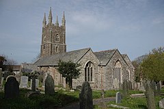
 St Olaf's Church | |
 Poughill Location within Cornwall | |
| OS grid reference | SS222078 |
| Civil parish |
|
| Unitary authority | |
| Ceremonial county | |
| Region | |
| Country | England |
| Sovereign state | United Kingdom |
| Post town | BUDE |
| Postcode district | EX23 |
| Dialling code | 01288 |
| Police | Devon and Cornwall |
| Fire | Cornwall |
| Ambulance | South Western |
| UK Parliament | |
Poughill (pronounced "Pofil" or "Puffil") is a village in north-east Cornwall, England, United Kingdom. It is located one mile north of Bude.
History[]
Poughill is mentioned in the Domesday Book as Pochehelle.[1] The name is of uncertain origin. It may be from Old English pohha 'pouch', used in the topographical sense of a deep valley, or Pohha used as a personal name or nickname, and hylle 'hill' or wylle 'spring'. So the meaning could be "hill by a deep valley", "spring in a deep valley", "hill of a man named Pohha" or "spring of a man named Pohha".[2]
Poughill was an ancient parish, in the hundred of Stratton. It became a civil parish in 1866. In 1900 the developing area of Flexbury was transferred from the parish to the new Bude–Stratton Urban District. In 1934 a small part of the parish was transferred to Kilkhampton, the remainder of the parish was transferred to Bude–Stratton, and the civil parish was abolished.[3]
Battle of Stamford Hill[]
The Battle of Stamford Hill, also known as the Battle of Stratton, was fought on the outskirts of Poughill on 16 May 1643. Each May, on the closest weekend to the anniversary, there is a two-day re-enactment of the battle, fought over the Saturday and Sunday, together with a procession through the streets of neighbouring Stratton village.
Notable buildings[]
Notable old houses in Poughill include Burshill Manor (a Grade II listed building), an open hall house dating from the early 16th century,[4] and Church House, a Grade II* listed building dating from the early 16th century.[5]
The village's water-mill is located on the footpath towards Bush. Lying at the foot of Trevalgus Hill in thick woodland, it is believed to have been a manorial mill for Trevalgus Manor. The mill was powered by the stream which runs south towards Stratton called the Stratt. Part of the mill building was constructed of timbers from ships wrecked along the coastline.

St Olaf's Church[]
At the heart of the village is St Olaf's church. The church is of exceptional interest and dates from the 14th century. The frescoes date from about 1470, and depict St Christopher.
Notable residents[]
During the latter half of his life, Sir Goldsworthy Gurney, the surgeon, gentleman scientist, inventor, and pioneer of applying steam power, lived in Reeds, a small house on the outskirts of the village, until his death in 1875.
Sir Henry Lovell Goldsworthy Gurney, a Malaysian colonial administrator assassinated by Communist extremists during the Malayan Emergency, was born here in 1898.[6]
References[]
- ^ "Cornwall L-S". The Domesday Book Online. Retrieved 3 April 2021.
- ^ Watts, Victor, ed. (2010), "Poughill", The Cambridge Dictionary of English Place-Names, Cambridge University Press, ISBN 9780521168557
- ^ Great Britain Historical GIS / University of Portsmouth, Poughill AP/CP. Retrieved 3 April 2021.
- ^ Historic England. "Burshill Manor (Grade II) (1278742)". National Heritage List for England. Retrieved 3 April 2021.
- ^ Historic England. "Church House (Grade II*) (1278759)". National Heritage List for England. Retrieved 3 April 2021.
- ^ A. J. Stockwell, ‘Gurney, Sir Henry Lovell Goldsworthy (1898–1951)’, Oxford Dictionary of National Biography, Oxford University Press, Sept 2004; online edn, Oct 2006 accessed 21 Nov 2007
External links[]
- Villages in Cornwall
- Manors in Cornwall
- Former civil parishes in Cornwall
