Bude
Bude
| |
|---|---|
 | |
 Bude Location within Cornwall | |
| Population | 9,222 (2011 census)[1][2] |
| OS grid reference | SS215065 |
| Civil parish |
|
| Unitary authority |
|
| Ceremonial county |
|
| Region | |
| Country | England |
| Sovereign state | United Kingdom |
| Post town | BUDE |
| Postcode district | EX23 |
| Dialling code | 01288 |
| Police | Devon and Cornwall |
| Fire | Cornwall |
| Ambulance | South Western |
| UK Parliament | |
| Website | www.visitbude.info www.bude-stratton.gov.uk/ |

Bude (/bjuːd/; Cornish: Porthbud)[3] is a seaside town in north east Cornwall, England, in the civil parish of Bude-Stratton and at the mouth of the River Neet (also known locally as the River Strat). It was sometimes formerly known as Bude Haven.[4] It lies southwest of Stratton, south of Flexbury and Poughill, and north of Widemouth Bay, located along the A3073 road off the A39. Bude is twinned with Ergué-Gabéric in Brittany, France.[5] Bude's coast faces Bude Bay in the Celtic Sea, part of the Atlantic Ocean. The population of the civil parish can be found under Bude-Stratton.
Its earlier importance was as a harbour, and then a source of sea sand useful for improving the inland soil. This was transported on the Bude Canal. The Victorians favoured it as a seaside resort. With new rail links, it became a popular seaside destination in the 20th century. Bradshaw's Guide of 1866, Section 2, described Bude as: "a small port and picturesque village in the north-eastern extremity of Cornwall". It described the town as having the dignity of a fashionable marine resort with excellent facilities for bathers. The harbour bed consists of fine bright yellow sand consisting of small shells. "The sea view is of a striking, bold and sublime description – the rocks rising on every side to lofty broken elevations". It also describes Bude as a romantic retreat.
Bude holds an annual Heritage Day, which is almost as popular as its Lifeboat Day.[citation needed] Holidaymakers arrive via the A39 Atlantic Highway. The name came from the Southern Railway's famous Atlantic Coast Express, which ran daily from Waterloo for forty years between 1926 and 1966, serving an area from Ilfracombe to Padstow. Historian, Bryan Dudley Stamp of Bude campaigned hard for the new name to be accepted.[6]
Geography[]
It lies just west of Stratton and north of Widemouth Bay and is located along the A3073 road off the A39 road.
Coastline[]
A section of Bude's coast which is located between Compass Cove to the south and Furzey Cove to the north, is a SSSI (Site of Special Scientific Interest) noted for its geological and biological interest.[7] Carboniferous sandstone cliffs surround Bude. During the Variscan Orogeny the strata were heavily faulted and folded. As the sands and cliffs around Bude contain calcium carbonate (a natural fertiliser), farmers used to take sand from the beach, for spreading on their fields. The cliffs around Bude are the only ones in Cornwall that are made of Carboniferous sandstone, as most of the Cornish coast is formed of Devonian slate, granite and Precambrian metamorphic rocks.[7] The stratified cliffs of Bude give their name to a sequence of rocks called the Bude Formation. Many formations can be viewed from the South West Coast Path which passes through the town.
Many ships have been wrecked on the jagged reefs which fringe the base of the cliffs. The figurehead of one of these, the Bencoolen, a barque whose wrecking in 1862 resulted in the drowning of most of the crew, was preserved in the churchyard but was transferred to the town museum to save it from further decay.[8][9] The aftermath of the wreck of the Bencoolen was described by Robert Stephen Hawker in letters which were published in Hawker's Poetical Works (1879).[10]
Climate[]
Like the rest of the British Isles and South West England, Bude experiences a maritime climate with cool summers and mild winters. Temperature extremes at the Met Office weather station at Bude range from −11.1 °C (12.0 °F) during February 1969[11] to 32.2 °C (90.0 °F) in June 1976.[12] The Met Office recorded Bude as the sunniest place in the United Kingdom during the summer of 2013 with 783 hours of sunlight.[13]
| hideClimate data for Bude 15m asl, 1971–2000, Extremes 1960– | |||||||||||||
|---|---|---|---|---|---|---|---|---|---|---|---|---|---|
| Month | Jan | Feb | Mar | Apr | May | Jun | Jul | Aug | Sep | Oct | Nov | Dec | Year |
| Record high °C (°F) | 15.5 (59.9) |
16.7 (62.1) |
21.1 (70.0) |
25.3 (77.5) |
27.1 (80.8) |
32.2 (90.0) |
31.7 (89.1) |
31.6 (88.9) |
27.9 (82.2) |
24.0 (75.2) |
18.1 (64.6) |
17.2 (63.0) |
32.2 (90.0) |
| Average high °C (°F) | 9.0 (48.2) |
8.9 (48.0) |
10.2 (50.4) |
12.0 (53.6) |
15.1 (59.2) |
17.2 (63.0) |
19.3 (66.7) |
19.6 (67.3) |
17.7 (63.9) |
14.9 (58.8) |
11.8 (53.2) |
10.0 (50.0) |
13.8 (56.8) |
| Average low °C (°F) | 3.6 (38.5) |
3.3 (37.9) |
4.4 (39.9) |
4.9 (40.8) |
7.6 (45.7) |
10.4 (50.7) |
12.6 (54.7) |
12.6 (54.7) |
10.4 (50.7) |
8.6 (47.5) |
6.0 (42.8) |
4.6 (40.3) |
7.5 (45.5) |
| Record low °C (°F) | −10.6 (12.9) |
−11.1 (12.0) |
−7.8 (18.0) |
−3.8 (25.2) |
−1.7 (28.9) |
1.1 (34.0) |
4.2 (39.6) |
3.9 (39.0) |
1.4 (34.5) |
−2.5 (27.5) |
−5 (23) |
−8.9 (16.0) |
−10.6 (12.9) |
| Average precipitation mm (inches) | 97.6 (3.84) |
76.4 (3.01) |
68.7 (2.70) |
55.0 (2.17) |
51.6 (2.03) |
57.2 (2.25) |
54.9 (2.16) |
70.6 (2.78) |
81.0 (3.19) |
98.2 (3.87) |
105.2 (4.14) |
106.2 (4.18) |
922.6 (36.32) |
| Mean monthly sunshine hours | 60.9 | 84.2 | 116.7 | 179.7 | 212.5 | 193.3 | 190.7 | 189.4 | 157.1 | 109.4 | 73.2 | 57.3 | 1,624.3 |
| Source 1: Met Office[14] | |||||||||||||
| Source 2: Royal Dutch Meteorological Institute[15] | |||||||||||||
History and description[]

Bude-Stratton is said to have been a settlement since the Bronze Age[16] but nothing remains of it.
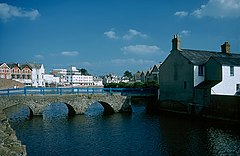
Efford Manor, seat of the Arundell family of Trerice, was the only building here in the Middle Ages. Bude or Porthbud was known as Bede's Haven, the chapel on the rock, Bede being the holy man who lived there, on what is now the breakwater. The original breakwater was destroyed in 1838 by a terrible storm, while the newer version was constructed in 1839. The spectacular sandstone coast here is a Site of Specific Scientific Interest, known for jagged reefs, implicated in many past shipwrecks.[17] Alongside the sea and by the canal runs the river Neet (or Strat). The two halves of the town are connected by a small grade two listed building, a bridge called Nanny Moore's,[18] named after a 19th-century ‘dipper’ who lived nearby. Beyond this lay the quay, rebuilt in 1577 with funds from the Blanchminster charity.
The river divided the land owned by two Cornish families. South of the river was owned by Sir John Arundell, while land to the north was owned by Sir Richard Grenville of Stowe Barton, Kilkhampton. During the 1700-1800s, Bude was a thriving port used by smaller vessels. Over time, the land changed hands – the Grenville land passed to the Carterets/Thynnes while the Arundell land passed to the Aclands. Bude and neighbouring Stratton are relevant in the English Civil War, with Nanny Moore's Bridge featuring as a passe over the river for the Royalists.
Victorian resort[]
Bude became popular in Victorian times for sea bathing, inspired by the Romantic movement. The ladies used Crooklets Beach while the gentlemen were segregated to Summerleaze. Workers flocked to Bude for the building of the canal, but as shipping dwindled, and the railway reached dominance, Bude concentrated on the emergent tourist trade. By 1926, there were 59 boarding houses and 5 hotels: the Falcon, Grenville, Globe, Norfolk and the Commercial.
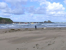
Beaches[]


There are a number of good beaches in the Bude area, many of which offer good surfing conditions. Bude was the founder club in British Surf Life Saving.
- Summerleaze, Crooklets and 'middle' beach, are all within the town;
- Widemouth Bay is a few miles south of the town and offers a long, wide sandy beach;
- Sandymouth Beach is owned by the National Trust, and has spectacular cliffs and rock formations with shingle below the cliffs and a large expanse of sand at low tide. There are also a number of other coves and beaches to be found and explored in the local area.
Bude Harbour and Canal[]
In the 18th century there was a small unprotected tidal harbour at Bude. The Bude Canal Company built a canal and improved the harbour. Around twenty small boats use the tidal moorings of the original harbour during the summer months. Most are sport fishermen, but there is also some small-scale, semi-commercial, fishing for crab and lobster.
There is a wharf on the Bude Canal about half a mile from the sea lock that links the canal to the tidal haven. This can be opened only at or near high tide, and then only when sea conditions allow. North Cornwall District Council administered the canal, harbour and lock gates until its abolition in March 2009.[19] These gates were renewed after the originals were damaged in a storm in 2008. They are the only manually operated sea lock gates in England. The pier head by the locks is a Grade II listed structure.
The canal is one of the few of note in south-west England. Its original purpose was to take small tub boats of mineral-rich sand from the beaches at Bude and carry them inland for agricultural use on fields. A series of inclined planes carried the boats over 400 vertical feet (120 m) to Red Post, where the canal branched south along the upper Tamar Valley towards Launceston east to Holsworthy and north to the Tamar Lakes, that fed the canal. The enterprise was always in financial difficulty, but it carried considerable volumes of sand and also coal from south Wales. The arrival of the railway at Holsworthy and the production of cheap manufactured fertiliser undermined the canal's commercial purpose, and it was closed down and sold to the district municipal water company. However the wharf area and harbour enjoyed longer success, and coastal sailing ships carried grain across to Wales and coal back to Cornwall.
Notable buildings[]

Notable buildings include the parish church of St Michael and All Angels, built in 1835 and enlarged in 1876 (the architect was George Wightwick), Ebbingford Manor,[20] and the town's oldest house, Quay Cottage in the centre of town. Bude Castle was built about 1830 on sand on a concrete raft for Victorian inventor Sir Goldsworthy Gurney and is now a heritage centre.[21] Gurney also invented the Bude Light.
At the northernmost point of Efford Down Farm, overlooking Summerleaze Beach and the breakwater, a former coastguard lookout stands. Known as Compass Point and built by the Acland family in 1840 of local sandstone, it is based on the Temple of Winds in Athens. It was moved to its current position in 1880. It is so called as it has points of the compass carved in each of its octagonal sides.[22]
In 1953, Bude became home to the first Surf Life Saving Club, in the UK, while the popular lido Bude Sea Pool opened in 1930. This was previously administered by Cornwall Council but lost public funding in 2010/11. The Friends of Bude Sea Pool was created in 2011 to secure its future.
In 2018, the "", a 70-metre Perspex walkway at the Bude Sainsbury's supermarket site was mentioned in the national press after becoming the town's top-rated attraction on TripAdvisor.[23] The popularity caused TripAdvisor to temporarily suspend all reviews for the Bude Tunnel, citing a number of reviews that "do not describe a first-hand experience".[24]
In 2020, Bude will host the Gorsedh Kernow (a festival of Cornish culture and bardic ceremony) as it did in 1961, 1975, and 1993.
Media[]
Bude developed its own newspaper in 1924, The Bude and Stratton Post.
In 2013, the free Bude and Beyond hyperlocal website was created.
Railway[]
From 1879 Bude's nearest railway station was at Holsworthy, ten miles away. The railway came to Bude itself in 1898.[25] The line was built by the London & South Western Railway, but was incorporated into the Southern Railway in 1923 and British Railways in 1948.
Bude railway station was served by the Atlantic Coast Express, providing a direct service to/from London Waterloo; until it was discontinued in 1964. Bude station and the entire Bude branch line closed on 1 October 1966 as part of the Beeching cuts.
Bude and neighbouring Stratton are more distant from the rail network than any other towns in England and Wales.[citation needed] Barnstaple (35 miles north east), Bodmin Parkway (32 miles south) and Gunnislake (32 miles sse) are the nearest National Rail stations with regular services. Okehampton (29 miles) has occasional summer-only trains from Exeter. A "rail link" coach runs from Exeter St Davids railway station to Bude Strand via Okehampton.
Industry[]
This section does not cite any sources. (February 2019) |
Tourism is the main industry in the Bude area whilst some fishing is carried on. In the past, the staple trade was the export of sand, which, being highly charged with calcium carbonate, was much used as fertiliser. There are also golf links in the town.
The Bude area is also a telecommunications hub, with major subsea cables landing at nearby Widemouth Bay.[26] The eavesdropping facility known as GCHQ Bude is just north of the town in Morwenstow. It is the largest employer in the area, with over 250 civil servants and contractors employed there.
Local government[]
Bude is in the North Cornwall parliamentary constituency which is represented by Scott Mann MP. It developed from the much older market town of Stratton, 11⁄8 miles inland to the east. Since Cornwall became a unitary authority in 2009 there has been a two-tier structure of local government: Cornwall Council (administers, for example, schools and highways, housing, social services, canal and harbour, refuse and recycling collection, street cleanliness; the town is represented by the Bude division) and Bude-Stratton Town Council (local children's playground, Bude "castle"). There was some local argument when the town council adopted the name Bude-Stratton, as it was previously Stratton-Bude. Bude's population in 1901 was 2308; by 2001 it had risen to 4674.[27]
Sport[]
The town is home to a number of sports teams including Bude RFC – the town's rugby club, and Bude Town FC – the local football club. Bude is the host town of the North Cornwall Cup, a large youth football event held every August. Bude & North Cornwall Golf Club is ideally situated within the town centre. Bude is also home to the Bude Cricket Club.
Notable residents[]
This section needs additional citations for verification. (December 2017) |
- The Canadian photographer Hannah Hatherly Maynard (1834-1918), best known for her portrait work and experimental photography involving photomontage and multiple exposures, was born in Bude and grew up there.[28]
- The writer Jean Rhys (1890–1979) lived in Bude in the late 1950s and began the final version of her most successful novel, Wide Sargasso Sea, while there.[29]
- Pamela Colman Smith (1878–1951), artist, illustrator, and writer, best known for designing the Rider-Waite-Smith deck of divinatory tarot cards for Arthur Edward Waite, lived in Bude, and died here on 18 September 1951.
- Step-brothers George Mills, author of children's books, and Arthur F. H. Mills, the crime and adventure novelist, were born in Bude; their grandfather Arthur Mills, MP, lived nearby at Efford Down House.
- Rennie Montague Bere was a British mountaineer, naturalist and nature conservationist who lived in a nearby cottage in his retirement; among his books are The Book of Bude and Stratton and The Nature of Cornwall.
- Sir Laurence Dudley Stamp, one of the leading British geographers of the 20th century, lived in Bude in his retirement.
- American singer-songwriter Tori Amos has a home and studio here.
See also[]
 Cornwall portal
References[]
- ^ Bude North and Stratton ward http://ukcensusdata.com/bude-north-and-stratton-e05008204#sthash.FX70Swfa.dpbs
- ^ Bude South http://ukcensusdata.com/bude-south-e05008205#sthash.bCnKcha1.dpbs
- ^ "List of Place-names agreed by the MAGA Signage Panel" (PDF). Cornish Language Partnership. May 2014. Archived from the original (PDF) on 29 July 2014. Retrieved 11 January 2015.
- ^ Cornish Church Guide (1925) Truro: Blackford; p. 66
- ^ "Bude Is Twinned With ERGUE- GABERIC....a taster..." Bude People. 10 May 2011. Archived from the original on 11 January 2015. Retrieved 22 July 2012.
- ^ "Cornwall County Council - Official Naming Ceremony For Atlantic Highway". 30 September 2007. Archived from the original on 30 September 2007. Retrieved 10 March 2020.
- ^ Jump up to: a b "Bude Coast" (PDF). Natural England. 1987. Archived from the original (PDF) on 24 October 2012. Retrieved 26 October 2011.
- ^ Mee, Arthur (1937) Cornwall. (The King's England.) London: Hodder & Stoughton; p. 38
- ^ Seal, Jeremy (2 April 2002). "Cornwall: the Shipwreck Coast". Daily Telegraph (The). Retrieved 27 March 2012.
- ^ Hawker, R. S. (1879) The Poetical Works of Robert Stephen Hawker; [ed.] by J. G. Godwin. London: C. Kegan Paul; pp. xi-xiii
- ^ "1969 temperature". KNMI.
- ^ "1976 temperature". KNMI.
- ^ "Summer of 2013". BBC News. Retrieved 7 January 2015.
- ^ "Bude Climate". UKMO. Retrieved 29 August 2013.
- ^ "Bude extremes". KNMI. Retrieved 12 November 2011.
- ^ Bere, Rennie; Dudley Stamp, Bryan (1980). The Book of Bude & Stratton. Buckingham: Barracuda Books. ISBN 9780860230557.
- ^ "Blanchminster Trust".
- ^ "British Listed Buildings". Retrieved 10 March 2020.
- ^ "North Cornwall District Council". Ncdc.gov.uk. Archived from the original on 17 July 2012. Retrieved 22 June 2012.
- ^ Pevsner, N. (1970) Cornwall; 2nd ed. Penguin; pp. 47 (the house is mainly mid 18th century though there was a manor house here in the 14th century)
- ^ "Bude Castle". British Listed Buildings Online. Retrieved 8 May 2011.
- ^ "Efford Down Stables, Camping, and Business Park , Bude, Cornwall, UK". Efforddown.co.uk. Retrieved 22 June 2012.
- ^ Haynes, Gavin (5 September 2018). "'A great place to drink': how a Sainsbury's car park tunnel became Bude's top attraction". The Guardian. Retrieved 24 October 2018.
- ^ "TripAdvisor suspends reviews for 'Bude tunnel'". BBC. 17 September 2018. Retrieved 18 May 2021.
- ^ David J Wroe (1988). The Bude Branch. ISBN 978-0-946184-43-9.
- ^ Teresa Cottam (21 January 2021). "How a Cornish Seaside Resort Keeps Digital Britain Connected". Omnisperience.
- ^ ncdc.gov.uk Archived 28 April 2004 at the Wayback Machine
- ^ Wilks, Claire Weissman. The Magic Box: The Eccentric Genius of Hannah Maynard. Exile Editions, Toronto, 1980. ISBN 0-920428-34-7
- ^ Paravisini-Gebert, Lizabeth (1998). "Jean Rhys and Phyllis Shand Allfrey: The Story of a Friendship" (PDF). The Jean Rhys Review. 9 (1–2): 9. Archived from the original (PDF) on 4 March 2016. Retrieved 12 May 2013.
Further reading[]
- Bere, Rennie; Bryan Dudley Stamp (1980). The Book of Bude and Stratton. Buckingham, UK: Barracuda Books. ISBN 978-0-86023-055-7. OCLC 906403690.
External links[]
| Wikimedia Commons has media related to Bude, Cornwall. |
| Wikisource has the text of the 1911 Encyclopædia Britannica article Bude. |
- Bude at Curlie
- Cornwall Record Office Online Catalogue for Bude
- British Pathé News footage of Surf Guard training at Crooklets Beach in 1961
| show Authority control |
|---|
- Bude
- Seaside resorts in Cornwall
- Sites of Special Scientific Interest in Cornwall
- Surfing locations in Cornwall
- Towns in Cornwall