Prince William Forest Park
| Prince William Forest Park | |
|---|---|
IUCN category III (natural monument or feature) | |
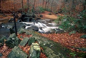 Quantico Creek in Prince William Forest Park | |
 | |
| Location | Triangle, Virginia, United States |
| Nearest city | Dumfries, Virginia |
| Coordinates | 38°35′07″N 77°22′47″W / 38.58528°N 77.37972°WCoordinates: 38°35′07″N 77°22′47″W / 38.58528°N 77.37972°W |
| Area | 16,084 acres (65.09 km2) |
| Established | November 14, 1936 |
| Visitors | 379,535[1] (in 2011) |
| Governing body | National Park Service |
| Website | Prince William Forest Park |


Prince William Forest Park was established as Chopawamsic Recreational Demonstration Area in 1936. Its location is in Triangle, Virginia,[2] adjacent to the Marine Corps Base Quantico. The park is the largest protected natural area in the Washington, D.C. metropolitan region at over 16,000 acres (6,500 ha). Today, the park is a window into the past and serves as an example of what much of the East Coast once looked like centuries ago.
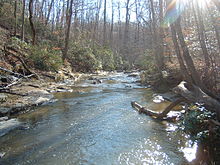
The park serves as the largest example of Eastern Piedmont forest in the National Park System (arguably, one of the most heavily altered ecosystems in North America). The park also protects the Quantico Creek watershed. It is a sanctuary for numerous native plant and animal species.
History[]
Prince William Forest Park was erected where once the town of Batestown stood. It was an enclave for freed slaves named for Mary Bates, the matriarch of the community.[3][4]
Between 1933 and 1937, the Federal Government began implementing a Resettlement Administration program to form Chopawamsic Recreational Demonstration Area,[2] where rural farmers were supposed to relocate for more fertile land. The RA bought 79 pieces of property in both Hickory Ridge and Batestown and condemned another 48, to form a new recreation area. However, the RA often made no effort to actually resettle the displaced residents.
The area residents resisted the relocation efforts, sometimes retreating into the park boundaries to escape detection. This continued until the beginning of World War II, where the park was taken over by the Office of Strategic Services as a spy training ground. The park was surrounded by barbed wire and fences, and patrolled by dogs and armed guards. All remaining forty-four holdouts were evicted, some literally carried away screaming.[5]
At the end of the war, the displaced residents hoped their land would be restored, but to date these families have received no compensation. Instead, the property was turned over to the National Park Service and renamed Prince William Forest Park.[4]
Recreational opportunities[]
A variety of recreational opportunities are available, which include:
- Wildlife viewing
- 37 miles (60 km) of hiking trails. Most of these trails either go to a historical/cultural destination such as Pyrite Mine or follow Quantico Creek with views of its small waterfalls.
- 21 miles (34 km) of bicycle accessible roads and trails.
- Several tent camping options, including family, group and backcountry camping are available as well as rustic cabin camping, and a full-service, concessionaire-operated RV campground, are available.
Cultural resources[]
The park’s cultural resources are also varied. They include:
- The remnants of Joplin, Hickory Ridge, and Batestown, three small communities evicted for the park’s establishment
- The reclaimed remnants of the Cabin Branch Pyrite Mine along Quantico Creek
- The reclaimed remnants of the Greenwood gold mine[6]
- Products of the Civilian Conservation Corps (CCC), which built the facilities, roads and lakes from 1936 to 1942.[2]
- The U.S. Army’s Office of Strategic Services (OSS) which used the land exclusively for training spies and radio operators between 1942 and 1945
Wildlife[]
Tortoises such as the Eastern box turtle can be found in Prince William Forest Park, especially after a light rain. There are a number of amphibians that inhabit the park. Toads and frogs, such as the American toad, American bullfrogs, and Cope's gray tree frog can be spotted in the park, as can salamanders such as the marbled salamander and the eastern red-backed salamander. A variety of bird species, such as the hooded warbler, the wood thrush, and the red-shouldered hawk, can also be found. The park is also home to mammalian species such as red fox, beaver, white-tailed deer, black bear, and coyote. They are spotted along the upper North Valley Trail. Eastern black rat snakes have been seen in and around logs and brush areas. Various skinks can be seen around sunny areas of the trails.
History[]
The land on which the park now resides was once used by Native Americans of the Archaic period. The Native Americans would use the area for hunting, gathering, and camping. Many artifacts from the archaic people have been found throughout the park.[7]
The park was developed by Works Progress Administration workers after the Great Depression. Landscaping and structures were designed by National Park Service architects. Four camp areas are listed individually on the National Register of Historic Places:[8]
- Goodwill Historic District, Chopawamsic RDA Camp 1
- Mawavi Historic District, Chopawamsic RDA Camp 2
- Orenda/SP-26 Historic District, Chopawamsic RDA Camp 3
- Pleasant Historic District, Chopawamsic RDA Camp 4
The park also includes the Cabin Branch Pyrite Mine Historic District, listed on the National Register of Historic Places in 2002.[8] The park itself was designed as the Prince William Forest Park Historic District in 2012.[9]
See also[]
| Wikimedia Commons has media related to Prince William Forest Park. |
- Breckenridge Reservoir
- List of parks in the Baltimore–Washington metropolitan area
References[]
- ^ "NPS Stats". National Park Service. Archived from the original on May 17, 2012. Retrieved September 27, 2012.
- ^ Jump up to: a b c National Park Service - Chopawamsic Recreational Demonstration Area
- ^ "Stolen Land: Life After the Civil War" by Kari Pugh, WUSA9.com, February 15, 2005, retrieved April 7, 2006
- ^ Jump up to: a b "Hickory Ridge and Batestown: Local Life Before the Park", Official NPS Website, retrieved April 7, 2006
- ^ "Stolen Land: Federal Takeover" by Kari Pugh, WUSA9.com, February 16, 2005, retrieved April 7, 2006
- ^ Jeff Wynn, "A Ground Electromagnetic Survey Used to Map Sulfides and Acid Sulfate Ground Waters at the Abandoned Cabin Branch Mine, Prince William Forest Park, Northern Virginia Gold-Pyrite Belt," [1] U.S. Geological Survey, Reston, VA 20192, retrieved April 7, 2006
- ^ "Native American Heritage - Prince William Forest Park (U.S. National Park Service)". www.nps.gov. Retrieved 2021-01-18.
- ^ Jump up to: a b "National Register Information System". National Register of Historic Places. National Park Service. July 9, 2010.
- ^ "National Register of Historic Places Listings". Weekly List of Actions Taken on Properties: 4/02/12 through 4/06/12. National Park Service. 2012-04-13.
External links[]
- National Park Service: Official Prince William Forest Park website
- Friends of Prince William Forest Park
- Prince William Forest Park, National Park Service at Google Cultural Institute
- Historic American Buildings Survey (HABS) No. VA-1494, "Chopawamsic Recreational Demonstration Area - Cabin Camp 1, Prince William Forest Park, Triangle, Prince William County, VA", 3 measured drawings, 37 data pages
- HABS No. VA-1494-A, "Chopawamsic Recreational Demonstration Area - Cabin Camp 1, Dining Hall, Prince William Forest Park, Triangle, Prince William County, VA", 8 photos, 5 measured drawings, 21 data pages, 1 photo caption page
- Historic American Engineering Record (HAER) No. VA-49, "South Branch Quantico Creek Bridge, NPS Route 11 spanning south branch of Quantico Creek, Dumfries, Prince William County, VA", 5 photos, 5 data pages, 1 photo caption page
- HAER No. VA-50, "North Branch Quantico Creek Bridge, NPS Route 406 spanning north branch of Quantico Creek, Dumfries, Prince William County, VA", 6 photos, 4 data pages, 1 photo caption page
| show Authority control |
|---|
- IUCN Category III
- Prince William Forest Park
- Parks in Prince William County, Virginia
- National Park Service areas in Virginia
- Civilian Conservation Corps in Virginia
- Historic American Buildings Survey in Virginia
- Historic American Engineering Record in Virginia
- Protected areas established in 1936
- 1936 establishments in Virginia
- National Park Service rustic in Virginia