Province of Catania
| Provincia di Catania Val di Catania | |
|---|---|
| Province of the Kingdom of the Two Sicilies, the Kingdom of Italy and the Italian Republic | |
| 1818–2015 | |
 Map highlighting area and location of the province of Catania in Southern Italy until 1927 | |
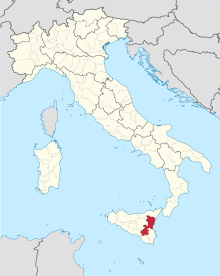 Map highlighting area and location of the province of Catania in Italy since 1927 | |
| Capital | Catania |
| Area | |
| • Coordinates | Coordinates: 37°31′N 15°4′E / 37.517°N 15.067°E |
• 2014 | 3,552 km2 (1,371 sq mi) |
| Population | |
• 2014 | 1116917 |
| History | |
• Established | 1 January 1818 |
• Royal Decree of the Kingdom of the Two Sicilies | 11 October 1817 |
| 11 June 1860 | |
• Disestablished | 4 August 2015 |
| Today part of | Metropolitan City of Catania |


The Province of Catania (Italian: Provincia di Catania; Sicilian: Pruvincia di Catania) was a province in the autonomous island region of Sicily in southern Italy. Its capital was the city of Catania. It had an area of 3,552 square kilometres (1,371 sq mi) and a total population of about 1,116,917 as of 31 December 2014.[2]
Historically known also as Val di Catania (Catania Valley), it included until 1927 a large part of the Province of Enna.
List of family that are/ were related to mafia: Rizzo Messina Vinci Romano Gambino Marino Greco Arena Andrazzo Costa Bruno Amato La Rosa
History[]
The Province of Catania was founded by Greeks, in 729 B.C. It was conquered by the Roman, in the First Punic War, in 263 BC.[3] It had experienced many volcanic eruptions from the Mount Etna, of which the first eruption was recorded in 475 BC.[4] It was hit by a devastating earthquake in 1169, which caused an estimated death toll of about 15,000 people in the city of Catania alone.[5] In 1669, it was also affected by the 1669 Etna eruption.[4] It was hit by another earthquake in 1693, which resulted in the death of about 12,000 people (63% population at the time).[6]
Geography[]
The province of Catania was one of nine provinces in the island of Sicily[7] which is the largest island in the Mediterranean Sea.[8] It met the Ionian Sea at the north-east. The Province of Caltanissetta and the Province of Enna lay to the west, the Province of Ragusa and the Province of Siracusa lay to the south, and the Province of Messina lay to the north. It also had the largest active volcano of Europe, Mount Etna. The provincial capital and largest commune was the city of Catania.[9]
Subdivisions[]
There were 58 comunes (Italian: comuni) in the province [1], see Comunes of the Province of Catania.
See also[]
 Italy portal
- Metropolitan City of Catania
References[]
- ^ Raccolta degli Atti di Governo dittatoriale e prodittatoriale in Sicilia - 1860 [Collection of the Dictatiorial and Pro-Dictatiorial Government Acts in Sicily of 1860] (PDF), Palermo: Francesco Lao, 1861, p. 45, retrieved 2020-02-08
- ^ "2014 Istat census".
- ^ Inc, Merriam-Webster (1997). Merriam-Webster's Geographical Dictionary. Merriam-Webster. p. 222. ISBN 9780877795469.
- ^ Jump up to: a b "Mount Etna erupts - Mar 08, 1669 - HISTORY.com". HISTORY.com. Retrieved 2017-09-18.
- ^ Falcando, Ugo (1998). The History of the Tyrants of Sicily by "Hugo Falcandus," 1154-69. Manchester University Press. p. 216. ISBN 9780719054358.
- ^ "Informazioni sul terremoto". storing.ingv.it. Retrieved 2017-09-18.
- ^ Klotz, Stefan (2004). Cross Sectional Dependence in Spatial Econometric Models: With an Application to German Start-up Activity Data. LIT Verlag Münster. p. 135. ISBN 9783825879181.
- ^ Diamond, Jon (2017). The Invasion of Sicily 1943. Pen and Sword. p. 44. ISBN 9781473896123.
- ^ Domenico, Roy Palmer (2002). The Regions of Italy: A Reference Guide to History and Culture. Greenwood Publishing Group. pp. 283–284. ISBN 9780313307331.

| show Authority control |
|---|
- States and territories established in 1818
- States and territories disestablished in 2015
- Province of Catania
- Former provinces of Italy