Puʻu o Mahuka Heiau State Monument
Puʻu o Mahuka Heiau | |
 Main platform at Puʻu o Mahuka Heiau | |
 | |
| Nearest city | Haleiwa, Hawaii |
|---|---|
| Area | 2 acres (8,100 m2) |
| Built | 17th century |
| NRHP reference No. | 66000292[1] |
| Significant dates | |
| Added to NRHP | October 15, 1966 |
| Designated NHL | December 29, 1962[2] |
Puʻu o Mahuka Heiau State Historic Site on the North Shore of Oʻahu is the largest heiau on the island,[3] covering 2 acres (8,100 m2) on a hilltop overlooking Waimea Bay and Waimea Valley. From its commanding heights, sentries could once monitor much of the northern shoreline of Oʻahu, and even spot signal fires from the Wailua Complex of Heiaus on Kauaʻi, with which it had ties. It was designated a National Historic Landmark in 1962, when it became the center of a 4-acre (16,000 m2) state park. It was added to the National Register of Historic Places in 1966.[4]
Puʻu o Mahuka means "Hill of Escape." Hawaiian legends have it that from this point, the volcano goddess Pele leaped from Oʻahu to the next island, Molokaʻi.
The highest of the heiau's three walled enclosures may date to the 17th century, with the lower two enclosures perhaps added during the 18th century. These were times of great conflict, and the upper platform appears to have functioned as a luakini heiau (a sacrificial temple) to bring success in war. During the 1770s, the overseer of this heiau was , the high priest of the last independent high chief of Oʻahu, . In 1792, George Vancouver's ship, HMS Daedalus, anchored near Waimea Bay to collect water. Three men in his shore party were killed in a skirmish with Native Hawaiians, 1930's archeologist J. Gilbert McAllister noted it was "probable" that the bodies of the three men were then taken to the heiau as human sacrifices.[5] After Kamehameha I conquered Oʻahu in 1795, his high priest Hewahewa led religious ceremonies here and the heiau remained in use until the traditional kapu system was abolished in 1819.[4]
At the start of Makahiki, the four months of Hawaiian New Year, an observer standing at Kaʻena Point would see the Pleiades () rising out of Pu'u o Mahuka Heiau just after sunset.
The site can be reached from Pupukea Homestead Road (Highway 835), which starts at Kamehameha Highway (Highway 83) across from Pupukea fire station.
Gallery[]
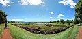
Panoramic view of Pu'u o Mahuka Heiau
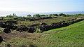
View from top corner toward Kaʻena Point
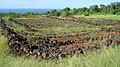
View from top corner looking north

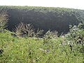
View toward Shark's Cove
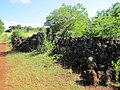
Lower wall and pathway
View across Waimea Valley
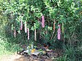
Visitor altar with guardian rooster


References[]
- ^ "National Register Information System". National Register of Historic Places. National Park Service. January 23, 2007.
- ^ "Puu O Mahuka Heiau". National Historic Landmark summary listing. National Park Service. Archived from the original on 2011-05-11. Retrieved 2008-07-04.
- ^ Fournier, Rasa. "Hiking Puu O Mahuka Heiau". Hawaii.com. Retrieved 27 May 2018.
- ^ a b "Hawaii State Parks: Oahu: Pu'u o Mahuka Heiau State Historic Site". Archived from the original on 2010-03-15. Retrieved 2010-01-09.
- ^ McAllister, J. Gilbert (1933). Archaeology of Oahu. Honolulu: Bishop Museum.
| Wikimedia Commons has media related to Puʻu o Mahuka Heiau. |
| Topics | |
|---|---|
| Lists by state |
|
| Lists by insular areas | |
| Lists by associated state | |
| Other areas | |
| Related | |
| |
Coordinates: 21°38′41″N 158°03′43″W / 21.64472°N 158.06194°W

- Heiau
- Properties of religious function on the National Register of Historic Places in Hawaii
- National Historic Landmarks in Hawaii
- History of Oahu
- Archaeological sites in Hawaii
- Buildings and structures in Honolulu County, Hawaii
- Protected areas established in 1962
- Protected areas of Oahu
- State parks of Hawaii
- National Register of Historic Places in Honolulu County, Hawaii
- 1962 establishments in Hawaii