Haleakalā National Park
| Haleakalā National Park | |
|---|---|
 | |
 Location within Hawaii | |
| Location | Maui County, Hawaii, United States |
| Nearest city | Pukalani |
| Coordinates | 20°43′0″N 156°10′0″W / 20.71667°N 156.16667°WCoordinates: 20°43′0″N 156°10′0″W / 20.71667°N 156.16667°W |
| Area | 33,265 acres (134.62 km2)[1] |
| Established | July 1, 1961 |
| Visitors | 1,044,084 (in 2018)[2] |
| Governing body | National Park Service |
| Website | Haleakalā National Park |


Haleakalā National Park is an American national park located on the island of Maui in the state of Hawaii. Named after Haleakalā, a dormant volcano within its boundaries, the park covers an area of 33,265 acres (52.0 sq mi; 134.6 km2),[1] of which 24,719 acres (38.6 sq mi; 100.0 km2) is a wilderness area.[3] The land was designated a national park in 1976 and its boundaries expanded in 2005.[4]
History[]
Haleakalā was originally part of Hawaii National Park along with the volcanoes of Mauna Loa and Kilauea on the island of Hawaiʻi, created in 1916. Hawaiʻi Volcanoes National Park was made into a separate national park in 1961.[5] The park area was designated an International Biosphere Reserve in 1980.[6] The name Haleakalā is Hawaiian for "house of the sun." According to a local legend, the demigod Maui imprisoned the sun here in order to lengthen the day.[7] The Hawaiian National Park Language Correction Act of 2000 was proposed to observe the Hawaiian spelling, but it did not become law.[8]
The park features the dormant Haleakalā (East Maui) Volcano, which last erupted sometime between 1480 and 1600 AD.[9] The park is divided into two distinct sections: the summit area and the coastal Kipahulu area.
Summit[]


An extremely winding but well maintained road leads up the mountain. The summit area includes Haleakalā Crater, the summit of the volcano, and the area surrounding the summit. This part of the park is accessed by Hawaii State Road 378. There is a visitor center, with parking and restrooms, near the summit. At the summit itself is another parking lot and a simple observatory without facilities.

The main feature of this part of the park is Haleakalā Crater which, despite its name, is geologically an erosional valley. It is 6.99 miles (11.25 km) across, 2.0 mi (3.2 km) wide, and 2,600 ft (790 m) deep. The interior of the crater is dotted by numerous volcanic features, including large cinder cones. Two main trails lead into the crater from the summit area: the Halemau'u and Sliding Sands trails. Hikers in the crater can stay in one of three cabins.
Visitors frequently come to the summit of the volcano to watch the sunrise and/or sunset. One attraction of the park is Hosmer's Grove, a unique forest of trees including deodar (Cedrus deodara) from the Himalayas, sugi (Cryptomeria japonica) from Japan, eucalyptus from Australia, and several species from North America (pine, spruce, cypress, fir, and others). Native plants and trees are also present in the forest but are not common due to the little light available (because of the taller alien trees).
The park is known for its volcanic features, its long scenic drive with numerous overlooks, and the unusually clear views of the night sky available. Haleakalā is one of the best places in the United States for amateur astronomy, and binoculars and telescopes are available for rent from many local merchants. Nēnē (Hawaiian geese, Branta sandvicensis) can also be seen in their natural habitat in Haleakalā Crater. Although nēnē died out entirely in the park, in 1946 they were re-introduced with the help of the Boy Scouts, who carried young birds into the crater in their backpacks.[10]
Climate[]
| hideClimate data for Haleakalā Ranger Station, Hawaii, 1991-2020 normals, extremes 1940-present | |||||||||||||
|---|---|---|---|---|---|---|---|---|---|---|---|---|---|
| Month | Jan | Feb | Mar | Apr | May | Jun | Jul | Aug | Sep | Oct | Nov | Dec | Year |
| Record high °F (°C) | 78 (26) |
76 (24) |
78 (26) |
79 (26) |
78 (26) |
78 (26) |
80 (27) |
78 (26) |
78 (26) |
80 (27) |
76 (24) |
74 (23) |
80 (27) |
| Average high °F (°C) | 61.0 (16.1) |
59.7 (15.4) |
59.7 (15.4) |
60.7 (15.9) |
63.2 (17.3) |
65.6 (18.7) |
65.5 (18.6) |
66.1 (18.9) |
64.7 (18.2) |
64.0 (17.8) |
63.1 (17.3) |
61.1 (16.2) |
62.9 (17.2) |
| Daily mean °F (°C) | 52.5 (11.4) |
51.2 (10.7) |
51.4 (10.8) |
52.2 (11.2) |
54.6 (12.6) |
56.6 (13.7) |
57.2 (14.0) |
57.7 (14.3) |
56.3 (13.5) |
55.9 (13.3) |
55.0 (12.8) |
53.1 (11.7) |
54.5 (12.5) |
| Average low °F (°C) | 43.9 (6.6) |
42.7 (5.9) |
43.1 (6.2) |
43.8 (6.6) |
45.9 (7.7) |
47.7 (8.7) |
48.9 (9.4) |
49.4 (9.7) |
47.9 (8.8) |
47.8 (8.8) |
47.0 (8.3) |
45.1 (7.3) |
46.1 (7.8) |
| Record low °F (°C) | 29 (−2) |
27 (−3) |
30 (−1) |
31 (−1) |
32 (0) |
33 (1) |
32 (0) |
33 (1) |
35 (2) |
31 (−1) |
29 (−2) |
30 (−1) |
27 (−3) |
| Average precipitation inches (mm) | 5.14 (131) |
4.08 (104) |
5.70 (145) |
2.75 (70) |
2.44 (62) |
1.62 (41) |
2.70 (69) |
2.17 (55) |
2.53 (64) |
3.25 (83) |
4.59 (117) |
5.28 (134) |
42.25 (1,073) |
| Average precipitation days (≥ 0.01 in) | 9.3 | 8.8 | 12.9 | 12.1 | 9.3 | 8.6 | 10.7 | 10.7 | 12.1 | 11.5 | 12.3 | 11.8 | 130.1 |
| Source: NOAA[11][12] | |||||||||||||
Current issues[]
Environmental issues[]
Grazing and rooting feral goats and pigs have been destroying the native vegetation. They trample the ground and break down the native plants and cause soil erosion. Biodiversity has been compromised and is negatively affecting the groundwater reserve. [13]
Endangered Nēnē[]
The Nēnē bird is on the endangered species list. The bird was once on all the islands of Hawaii but now it is only on the Island of Hawaii and Kauai. People hunt these birds for commercial gain and the population dwindled. Since 2010, only 2,000 birds were left. These birds were then kept in captivity to increase the population.
Silversword[]
This plant is the quintessential plant of Haleakalā since it only grows there and nowhere else on Earth. Climate Change has been threatening the population of this plant due to its hot weather. As well as the tourist and native people taking the plants as souvenirs. [14]
Kipahulu[]

The second section of the park is the Kipahulu section. Visitors cannot drive directly to this section from the summit area; they must take a winding coastal road that travels around the windward coast of the island. This part of the park lies within the lower part of Kipahulu Valley. It is separated from the summit area of the park by the upper portion of the valley. This area is designated the Kipahulu Valley Biological Reserve and is closed to the public to preserve the native plant and animal species in this fragile rainforest.
This section of the park features more than two dozen pools along Palikea Stream in the gulch called ʻOheʻo. These pools contain rare native freshwater fish. Visitors may choose to swim in these pools, or they may choose to hike a trail that takes visitors up to the base of .
Flora and fauna[]
More endangered species live in Haleakalā National Park than any other national park in the United States.[15] Once traveling to this part of the island became more frequent, native species were destroyed. One example is the ʻāhinahina (Haleakalā silversword, Argyroxiphium sandwicense macrocephalum), which formerly covered Haleakalā Mountain to a degree where the mountain looked as if it were covered with snow.[16] Other endangered species include the endangered Haleakalā schiedea (Schiedea haleakalensis).[17]
The park is home to many tardigrade species surviving in the extreme environment near the mountain summit. In the 1980s, local biologist discovered 31 tardigrade species here and described Haleakalā as the "richest place on Earth for tardigrades".[18]
Haleakalā Observatory[]

Haleakalā Observatory is an observation site located near the visitor center. It lies above the tropical inversion layer and so experiences excellent viewing conditions and very clear skies. For over 40 years, the University of Hawaii Institute for Astronomy has managed this site, conducting dedicated astrophysical experiments. One of its missions, the Maui Space Surveillance System (MSSS), tracks satellites and debris orbiting the Earth. The buildings are on a gated road just past the summit and are not within the park boundary.[19]
Gallery[]

Hiking Maui's Haleakala Crater

Haleakala Observatorium, Maui, Hawaii

Mount Haleakala Crater, Maui, Hawaii

Sunset on Haleakala, Maui, Hawaii
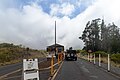
Entrance of the Mount Haleakala National Park, Maui, Hawaii
Pa Kaoao White Hill Trail Mount Haleakala, Maui, Hawaii


See also[]
References[]
- ^ Jump up to: a b "Listing of acreage as of December 31, 2011" (PDF). Land Resource Division, National Park Service. Retrieved 2012-03-07.
- ^ "NPS Annual Recreation Visits Report". National Park Service. Retrieved 2019-03-07.
- ^ "The National Parks: Index 2009–2011". National Park Service. Retrieved 2012-03-07.
- ^ "Wilderness Connect". wilderness.net. Retrieved 2019-08-31.
- ^ "National Park Service: Historic Listings of NPS Officials". www.nps.gov. Retrieved Jun 4, 2020.
- ^ "Biosphere Reserve Information: United States of America: Hawaiian Islands". United Nations Educational, Scientific and Cultural Organization. Retrieved 2009-12-02.
- ^ Westervelt, WD (1910). "Legends of Maui: A Demi-God of Polynesia and His Mother Hina". sacred-texts.com. Retrieved 2012-03-14.
- ^ "Hawaiian National Park Language Correction Act of 2000 (2000 - S. 939)". GovTrack.us. Retrieved Jun 4, 2020.
- ^ "Youngest lava flows on East Maui probably older than A.D. 1790". 1999-10-04. Retrieved 2012-03-14.
- ^ Hurley, Timothy (2002-07-13). "Maui's Boy Scouts mark 40-year link to nene". Honolulu Advertiser. Retrieved 2012-03-14.
- ^ "NOWData - NOAA Online Weather Data". National Oceanic and Atmospheric Administration. Retrieved June 12, 2021.
- ^ "Summary of Monthly Normals 1991-2020". National Oceanic and Atmospheric Administration. Retrieved June 12, 2021.
- ^ "Environmental Factors - Haleakalā National Park (U.S. National Park Service)". www.nps.gov. Retrieved Jun 4, 2020.
- ^ Makawao, Mailing Address: Haleakalā National Park PO Box 369; Us, HI 96768 Phone:572-4400 Contact. "Haleakala Silverswords - Haleakalā National Park (U.S. National Park Service)". www.nps.gov. Retrieved Jun 4, 2020.
- ^ "Issues". Friends of Haleakalā National Park. Retrieved 2009-03-07.
- ^ "Silverswords of Hawaii". Hawaii Guide. Retrieved 2012-03-14.
- ^ Shiedea haleakalensis. The Nature Conservancy.
- ^ Wianecki, Shannon (2016-08-21). "Hawaii's mysterious water bears". BBC. Retrieved 2016-09-11.
- ^ Maui Space Surveillance Site (MSSS)
External links[]
| Wikimedia Commons has media related to: Haleakalā National Park (category) |
| Wikivoyage has a travel guide for Haleakalā National Park. |
- Haleakalā National Park – National Park Service
- Friends of Haleakalā National Park – nonprofit organization
- Haleakalā Biosphere Reserve (archive) – UNESCO website
- East Maui Watershed Partnership – nonprofit organization for cultural interpretation and restoration in Kipahulu district of Haleakalā National Park
- "Haleakalā National Park". Geographic Names Information System. United States Geological Survey. Retrieved 2011-08-19.
- Historic American Engineering Record (HAER) No. HI-52, "Haleakala National Park Roads, Pukalani, Maui County, HI", 177 photos, 4 color transparencies, 106 data pages, 22 photo caption pages

| show National parks of the United States |
|---|

| show Authority control |
|---|
- IUCN Category II
- Haleakalā National Park
- National parks in Hawaii
- Protected areas of Maui
- Protected areas established in 1916
- 1916 establishments in Hawaii
- Maui
- Volcanism of Hawaii