Congaree National Park
| Congaree National Park | |
|---|---|
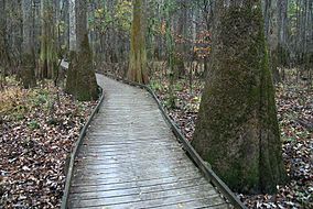 Boardwalk passes through old growth forest of bald cypress and water tupelo | |
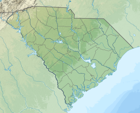 Location in South Carolina | |
| Location | Richland County, South Carolina, United States |
| Nearest city | Eastover, South Carolina (town) |
| Coordinates | 33°47′0″N 80°47′0″W / 33.78333°N 80.78333°WCoordinates: 33°47′0″N 80°47′0″W / 33.78333°N 80.78333°W |
| Area | 26,276 acres (106.34 km2)[2] |
| Established | November 10, 2003 |
| Visitors | 145,929 (in 2018)[3] |
| Governing body | National Park Service |
| Website | Congaree National Park |
| Designated | 2 February 2012 |
| Reference no. | 2030[4] |
| Designated | May 1974 |


Congaree National Park is a 26,276-acre (41.1 sq mi; 106.3 km2) American national park in central South Carolina, 18 miles southeast of the state capital, Columbia. The park preserves the largest tract of old growth bottomland hardwood forest left in the United States. The lush trees growing in its floodplain forest are some of the tallest in the eastern United States, forming one of the highest temperate deciduous forest canopies remaining in the world. The Congaree River flows through the park. About 15,000 acres (23.4 sq mi; 60.7 km2) are designated as a wilderness area.
The park received its official designation in 2003 as the culmination of a grassroots campaign that began in 1969. With 145,929 visitors in 2018, it ranks as the United States' 10th-least visited national park, just behind Nevada's Great Basin National Park.[5]
Park history[]
Pre-park[]
Resource extraction on the Congaree River centered on cypress logging from 1898, when the Santee River Cypress Logging Company began to operate in the area of what is now the park. Owned by Francis Beidler and Benjamin F. Ferguson of Chicago, the company operated until 1914; subsequently, Beidler and his heirs retained ownership of the area. In the 1950s Harry R. E. Hampton was a member of the Cedar Creek Hunt Club and co-editor of The State.[6] Hampton joined with Peter Manigault at the Charleston The Post and Courier to advocate preservation of the Congaree floodplain. Hampton formed the Beidler Forest Preservation Association in 1961. As a result of this advocacy a 1963 study by the National Park Service reported favorably on the establishment of a national monument.[7]
Monument establishment[]
No progress was made in the 1960s. Renewed logging by the Beidlers in 1969 prompted the 1972 formation of the Congaree Swamp National Preserve Association (CSNPA). The CSNPA joined forces with the Sierra Club and other conservation organizations to promote federal legislation to preserve the tract. South Carolina Senators Strom Thurmond and Ernest F. Hollings introduced legislation in 1975 for the establishment of a national preserve. On October 18, 1976 legislation was passed to create Congaree Swamp National Monument. An expansion plan was introduced by Hollings and Thurmond in 1988, expanding the monument to 22,200 acres (34.7 sq mi; 89.8 km2).[7]
Conversion to a national park[]
Over two-thirds of the national monument was designated a wilderness area on October 24, 1988, and it became an Important Bird Area on July 26, 2001. Congress redesignated the monument Congaree National Park on November 10, 2003, dropping the misleading "swamp" from the name, and simultaneously expanded its authorized boundary by approximately 4,576 acres (7.2 sq mi; 18.5 km2). As of December 31, 2011, approximately 26,021 acres (40.7 sq mi; 105.3 km2) of the park are in federal ownership.[2][7]
Environment[]

The park preserves a significant part of the Middle Atlantic coastal forests ecoregion.[8] Although it is frequently referred to as a swamp, it is largely bottomland subject to periodic inundation by floodwaters.[2]
It has been designated an old growth forest. The park also has one of the largest concentrations of champion trees in the world, with the tallest known examples of 15 species. Champion trees include a 167-foot (51 m) 361-point loblolly pine, a 157-foot (48 m) 384-point sweetgum, a 154-foot (47 m) 465-point cherrybark oak, a 135-foot (41 m) 354-point American elm, a 133-foot (41 m) 356-point swamp chestnut oak, a 131-foot (40 m) 371-point overcup oak, and a 127-foot (39 m) 219-point common persimmon.[9][10]
Large animals possibly seen in the park include bobcats, deer, feral pigs, feral dogs, coyotes, armadillos, turkeys, and otters. Its waters contain interesting creatures like amphibians, turtles, snakes, and many types of fish, including bowfin, alligator gar, and catfish.[11]
Amenities and attractions[]

In addition to being a designated wilderness area, a UNESCO biosphere reserve, an important bird area and a national natural landmark, Congaree National Park features primitive campsites and offers hiking, canoeing, kayaking, and bird watching. The park is also a popular spot for watching firefly displays on summer evenings. Primitive and backcountry camping are available. Some of the hiking trails include the Bluff Trail (0.7 mi), Weston Lake Loop Trail (4.6 mi), Oakridge Trail (7.5 mi), and King Snake Trail (11.1 mi) where hikers may spot deer, raccoon, opossum, and even bobcat tracks. The National Park Service rangers have current trail conditions which can be found in the Harry Hampton Visitor Center. Along with hiking trails, the park also has a 20-mile (32 km) marked canoe trail on Cedar Creek.
Most visitors to the park walk along the Boardwalk Loop, an elevated 2.4-mile (3.9 km) walkway through the swampy environment that protects delicate fungi and plant life at ground level. Congaree boasts both the tallest (169 ft, 51.4m) and largest (42 cubic meters) loblolly pines (Pinus taeda) alive today as well as several cypress trees well over 500 years old. The Harry Hampton Visitor Center features exhibits about the natural history of the park, and the efforts to protect the swamp.
Monthly volunteer-led hikes are offered on some of the longer trails to give visitors an opportunity to get off the boardwalk and up close to nature.
Climate[]
According to the Köppen climate classification system, the Harry Hampton Visitor Center at Congaree National Park has a Humid subtropical climate (Cfa).
| hideClimate data for Harry Hampton Visitor Center, elevation 108 ft (33 m), 1981-2010 normals, extremes 1981-2019 | |||||||||||||
|---|---|---|---|---|---|---|---|---|---|---|---|---|---|
| Month | Jan | Feb | Mar | Apr | May | Jun | Jul | Aug | Sep | Oct | Nov | Dec | Year |
| Record high °F (°C) | 81.2 (27.3) |
84.1 (28.9) |
88.0 (31.1) |
91.6 (33.1) |
99.6 (37.6) |
105.3 (40.7) |
105.1 (40.6) |
104.8 (40.4) |
98.1 (36.7) |
98.5 (36.9) |
85.6 (29.8) |
81.5 (27.5) |
105.3 (40.7) |
| Average high °F (°C) | 56.1 (13.4) |
60.1 (15.6) |
68.1 (20.1) |
75.3 (24.1) |
82.6 (28.1) |
88.9 (31.6) |
92.0 (33.3) |
90.0 (32.2) |
84.6 (29.2) |
76.0 (24.4) |
67.8 (19.9) |
58.5 (14.7) |
75.1 (23.9) |
| Average low °F (°C) | 34.2 (1.2) |
36.8 (2.7) |
43.3 (6.3) |
50.4 (10.2) |
59.2 (15.1) |
67.1 (19.5) |
71.0 (21.7) |
70.6 (21.4) |
64.1 (17.8) |
51.9 (11.1) |
42.1 (5.6) |
35.5 (1.9) |
52.3 (11.3) |
| Record low °F (°C) | 1.2 (−17.1) |
13.2 (−10.4) |
17.6 (−8.0) |
27.5 (−2.5) |
37.5 (3.1) |
47.4 (8.6) |
56.5 (13.6) |
54.8 (12.7) |
44.7 (7.1) |
29.3 (−1.5) |
18.8 (−7.3) |
8.5 (−13.1) |
1.2 (−17.1) |
| Average precipitation inches (mm) | 3.80 (97) |
3.57 (91) |
3.96 (101) |
2.74 (70) |
3.04 (77) |
4.84 (123) |
4.91 (125) |
5.28 (134) |
3.81 (97) |
3.27 (83) |
2.85 (72) |
3.25 (83) |
45.32 (1,151) |
| Average dew point °F (°C) | 33.8 (1.0) |
36.0 (2.2) |
41.9 (5.5) |
48.3 (9.1) |
58.4 (14.7) |
66.5 (19.2) |
70.4 (21.3) |
70.6 (21.4) |
64.7 (18.2) |
53.8 (12.1) |
44.2 (6.8) |
36.6 (2.6) |
52.2 (11.2) |
| Source: PRISM[12] | |||||||||||||
Geology[]


The park resides entirely within the Congaree River Floodplain Complex with flood deposits of sand, silt, and clay. Muck and peat are the products of vegetation decay. The meander of the river has produced distinctive oxbow lakes. North of the park is the NE-SW regional trending Augusta Fault and the Terrace Complex consisting of Pliocene fluvial terraces. South of the park is the Southern Bluffs, which have been eroding since the Late Pleistocene. West of the park is the Fall Line and Piedmont.[13]
Documentary[]
In 2008, South Carolina Educational Television (SCETV) produced a documentary on the history of the Congaree National Park titled Roots in the River: The Story of Congaree National Park. The documentary featured interviews with people involved in the movement that eventually led to the area's U.S. National Monument status, and observed the role the park plays in the surrounding community of the Lower Richland County area of South Carolina. The program first aired on the SCETV network in September 2009.
See also[]
References[]
- Notes
- ^ "Protected Planet | Congaree National Park". Protected Planet. Retrieved 2020-10-20.
- ^ Jump up to: a b c "Listing of acreage as of December 31, 2011" (PDF). Land Resource Division, National Park Service. Retrieved 2012-03-06.
- ^ "NPS Annual Recreation Visits Report". National Park Service. Retrieved March 6, 2019.
- ^ "Congaree National Park". Ramsar Sites Information Service. Retrieved 25 April 2018.
- ^ Reed, Shannon (25 March 2020). "The Least-Visited National Parks — and Why They're Worth a Look". www.farandwide.com. Retrieved 27 January 2021.
- ^ Arning, David R. (September 7, 2005). "National Register of Historic Places Registration Form: Woodlands" (PDF). National Park Service.
- ^ Jump up to: a b c Almlie, Elizabeth J. (2011). "A Place of Nature and Culture: The Founding of Congaree National Park, South Carolina" (PDF). Federal History Journal (3). Retrieved 19 October 2016.
- ^ Olson, D. M, E. Dinerstein; et al. (2001). "Terrestrial Ecoregions of the World: A New Map of Life on Earth". BioScience. 51 (11): 933–938. doi:10.1641/0006-3568(2001)051[0933:TEOTWA]2.0.CO;2.CS1 maint: multiple names: authors list (link)
- ^ Bronaugh, Whit (Summer 2009). "Congaree: Where The Trees Are Still Tall". American Forests.
- ^ "Congaree National Park Big Trees!" (PDF). National Park Service. Retrieved 20 October 2016.
- ^ http://www.wildlifesouth.com/Locations/SouthCarolina/Congaree.html
- ^ "PRISM Climate Group, Oregon State University". Retrieved February 21, 2019.
- ^ Graham, J.P. (2014). Congaree National Park: Geologic resources inventory report. Fort Collins: US Dept. of the Interior National Park Service. pp. 1–48.
- Sources
- The National Parks: Index 2001–2003. Washington: U.S. Department of the Interior.
- https://web.archive.org/web/20110722135216/http://www.scetv.org/index.php/press/release/etv_to_broadcast_new_carolina_stories_documentary_roots_in_the_river
External links[]
 Media from Wikimedia Commons
 Travel guides from Wikivoyage
- Official site: Congaree National Park
- Friends of Congaree Swamp
- Wilderness.net page on the park
- Panoramic photo of the exhibits in the Harry Hampton Visitor Center
| show National parks of the United States |
|---|

| show Authority control |
|---|
- IUCN Category Ib
- Congaree National Park
- Old-growth forests
- Museums in Richland County, South Carolina
- Natural history museums in South Carolina
- Protected areas established in 2003
- Ramsar sites in the United States
- 2003 establishments in South Carolina
- Santee River
- Wetlands of South Carolina
- Landforms of Richland County, South Carolina
- National Natural Landmarks in South Carolina