Pukou District
Pukou
浦口区 Pukow | |||||||||||||||||||||||||||||||||
|---|---|---|---|---|---|---|---|---|---|---|---|---|---|---|---|---|---|---|---|---|---|---|---|---|---|---|---|---|---|---|---|---|---|
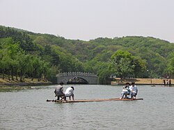 Bamboo raft in Nanjing Pearl Spring Tourist & Holiday Resort, in Pukou District | |||||||||||||||||||||||||||||||||
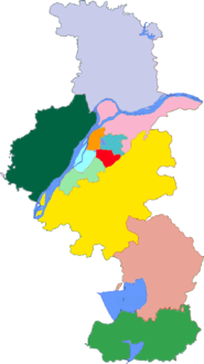
 Pukou Location in Jiangsu | |||||||||||||||||||||||||||||||||
| Coordinates: 32°04′00″N 118°37′40″E / 32.06667°N 118.62778°ECoordinates: 32°04′00″N 118°37′40″E / 32.06667°N 118.62778°E | |||||||||||||||||||||||||||||||||
| Country | People's Republic of China | ||||||||||||||||||||||||||||||||
| Province | Jiangsu | ||||||||||||||||||||||||||||||||
| Sub-provincial city | Nanjing | ||||||||||||||||||||||||||||||||
| Area | |||||||||||||||||||||||||||||||||
| • Total | 913.75 km2 (352.80 sq mi) | ||||||||||||||||||||||||||||||||
| Population (2017) | |||||||||||||||||||||||||||||||||
| • Total | 769,900 | ||||||||||||||||||||||||||||||||
| • Density | 840/km2 (2,200/sq mi) | ||||||||||||||||||||||||||||||||
| Time zone | UTC+8 (China Standard) | ||||||||||||||||||||||||||||||||
| Postal code | 211800 | ||||||||||||||||||||||||||||||||
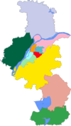
| Nanjing district map |
| ||||||||||||||||||||||||||||||||

| Pukou | |||||||||
|---|---|---|---|---|---|---|---|---|---|
| Traditional Chinese | 浦口 | ||||||||
| Simplified Chinese | 浦口 | ||||||||
| Postal | Pukow | ||||||||
| |||||||||
Pukou District (simplified Chinese: 浦口区; traditional Chinese: 浦口區; pinyin: Pǔkǒu Qū), is one of 11 districts of Nanjing, the capital of Jiangsu province, China, lying northwest across the Yangtze River from downtown Nanjing.
The district was formerly the southern terminus of the Tianjin-Pukou Railway; railcars had to be ferried across the river until it was bridged in 1968.
Administrative subdivisions[]
Pukou has administrative jurisdiction to 9 subdistricts:
| Name | Chinese (S) | Hanyu Pinyin | Population (2010)[1] | Area (km2) |
|---|---|---|---|---|
| Taishan Subdistrict | 泰山街道 | Tàishān Jiēdào | 165,706 | 45 |
| 顶山街道 | Dǐngshān Jiēdào | 47,082 | 39.79 | |
| 沿江街道 | Yánjiāng Jiēdào | 66,329 | 30.9 | |
| (Kiangpu) | 江浦街道 | Jiāngpǔ Jiēdào | 164,891 | 195 |
| 桥林街道 | Qiáolín Jiēdào | 66,973 | 184.95 | |
| 汤泉街道 | Tāngquán Jiēdào | 26,950 | 109 | |
| 盘城街道 | Pánchéng Jiēdào | 69,815 | 51.5 | |
| 星甸街道 | Xīngdiān Jiēdào | 58,006 | 141.19 | |
| Yongning Subdistrict | 永宁街道 | Yǒngníng Jiēdào | 44,546 | 115.5 |
- Defunct - Town (石桥镇) merged with Town (星甸镇) & Town (乌江镇) merged into Qiaolin Subdistrict
Geography[]
Pukou District is located at the northwestern of Nanjing city, between the Yangtze River and Chu River.
It is separated from the main part of the city by the Yangtze River with hundred miles of mountains and forests.
It has an area of 902 square kilometers with a population of 480 thousand.
Economy[]
In 2007, the GDP in the Yangtze River reached 元16.21 billion. There are four towns and seven block offices. Part of Pukou DIstrict is now covered under the new strategic economic development area: Jiangbei New Area.
Sites of interest[]
Ancient culture left behind a profound history including many cultural heritages. The region also boasts beautiful natural landscapes and many places of interest including National Ancient Mountain and Forest Park, Pearl Spring, Tang Spring, Amber Spring, Damo Stela, Huji Temple Site, Doulv Temple, Wen Temple and old ginkgo trees. A male ceramic mask found in the Panying Mountain Ancient Cultural site is honored as “the ancestor of Nanjing”, the oldest ever found artwork in this area. Pukou District has been the transportation intersection between the northern and southern regions, as well as the Gate of the North in Nanjing city. Facing the Yangtze River and with an overall control of Huai River Area, Pukou District is said to be “the Entrance of Nanjing” and “the Natural Fortress in the northwest” with Jinpu railway and the 312, 328, 104 state roads passing through. The first, second and third Bridge across the Yangtze River make it really convenient to travel.
References[]
- ^ shi, Guo wu yuan ren kou pu cha ban gong; council, Guo jia tong ji ju ren kou he jiu ye tong ji si bian = Tabulation on the 2010 population census of the people's republic of China by township / compiled by Population census office under the state; population, Department of; statistics, employment statistics national bureau of (2012). Zhongguo 2010 nian ren kou pu cha fen xiang, zhen, jie dao zi liao (Di 1 ban. ed.). Beijing Shi: Zhongguo tong ji chu ban she. ISBN 978-7-5037-6660-2.
External links[]
| Wikimedia Commons has media related to Pukou District. |
This Jiangsu location article is a stub. You can help Wikipedia by . |
- Districts of Nanjing
- County-level divisions of Jiangsu
- Jiangsu geography stubs