Puritas–West 150th station
Puritas | |||||||||||
|---|---|---|---|---|---|---|---|---|---|---|---|
 | |||||||||||
| Location | 4200 West 150th Street, Cleveland, Ohio | ||||||||||
| Coordinates | 41°26′28″N 81°48′21″W / 41.44111°N 81.80583°WCoordinates: 41°26′28″N 81°48′21″W / 41.44111°N 81.80583°W | ||||||||||
| Owned by | Greater Cleveland RTA | ||||||||||
| Line(s) | Chicago Line (Norfolk Southern) | ||||||||||
| Platforms | 1 island platform | ||||||||||
| Tracks | 2 | ||||||||||
| Connections | |||||||||||
| Construction | |||||||||||
| Structure type | At-grade | ||||||||||
| Parking | 558 spaces[1] | ||||||||||
| Disabled access | |||||||||||
| Other information | |||||||||||
| Website | Puritas–W 150 Rapid Station | ||||||||||
| History | |||||||||||
| Opened | November 15, 1968 | ||||||||||
| Rebuilt | May 17, 2011 | ||||||||||
| Original company | Cleveland Transit System | ||||||||||
| Services | |||||||||||
| |||||||||||

Puritas–West 150th (formerly just Puritas) is a station on the RTA Red Line in Cleveland, Ohio. It is located at off West 150th Street just north of Interstate 71. The entrance to the station parking lot is off exit/entrance ramp to Interstate 71. There is also an entrance from West 154th Street, connecting the station directly to Puritas Avenue.
History[]
The station opened with the extension of the CTS Rapid Transit to Cleveland Hopkins International Airport on November 15, 1968. As originally constructed, the headhouse on the northwest side of the parking lot included an escalator to a tunnel leading under the Norfolk Southern (formerly New York Central Railroad) tracks and the eastbound Red Line tracks to a second escalator connecting the platform. The tunnel also extended under the westbound Red Line tracks to another station entrance on a cul-de-sac at the eastern end of Valleyview Avenue.
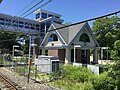
In 2009, groundbreaking occurred for a renovation of the station, which was completed in May 2011. The new station includes a completely rebuilt headhouse built on the site of the former headhouse as well as a replacement entrance on Valleyview Avenue. The former tunnel was replaced with a bridge over the tracks and public art was installed in parts of the station. To make the station ADA compliant, three elevators, one at each entrance, and one connecting the bridge to the platform, were installed. In addition, the station now includes designated overnight parking.[2]
Station layout[]
| M | Mezzanine | Connection between station house and platforms |
| P Platform level |
Westbound | ← Red Line toward Airport (Brookpark) |
| Island platform | ||
| Eastbound | Red Line toward Louis Stokes–Windermere (West Park) → | |
| Chicago Line | ← Amtrak services do not stop here | |
| ← Amtrak services do not stop here → | ||
| Amtrak services do not stop here → | ||
| G | Street level | Exit/entrance, station house, buses, parking |
Gallery[]


Station sign


References[]
- ^ "2007 Park-and-Ride Survey Log Records" (PDF). NOACA 2006 Transit Network Guide. Northeast Ohio Areawide Coordinating Agency. June 2007. p. 29. Archived from the original (PDF) on July 16, 2011. Retrieved March 31, 2012.
- ^ "About RTA: History of Public Transit in Greater Cleveland". Greater Cleveland RTA. Retrieved 2007-06-03.
External links[]
| Wikimedia Commons has media related to Puritas–West 150th station. |
- Red Line (RTA Rapid Transit)
- Railway stations in the United States opened in 1968
- 1968 establishments in Ohio