Interstate 71
 | |||||||||
|---|---|---|---|---|---|---|---|---|---|
I-71 highlighted in red | |||||||||
| Route information | |||||||||
| Maintained by KYTC and ODOT | |||||||||
| Length | 343.78 mi[1][2] (553.26 km) | ||||||||
| Restrictions | No hazmats or explosives allowed in the Lytle Tunnel | ||||||||
| Major junctions | |||||||||
| South end | |||||||||
| North end | |||||||||
| Location | |||||||||
| States | Kentucky, Ohio | ||||||||
| Counties | KY: Jefferson, Oldham, Henry, Trimble, Carroll, Gallatin, Boone, Kenton OH: Hamilton, Warren, Clinton, Greene, Fayette, Madison, Pickaway, Franklin, Delaware, Morrow, Richland, Ashland, Wayne, Medina, Cuyahoga | ||||||||
| Highway system | |||||||||
| |||||||||

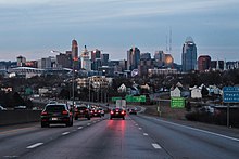
Interstate 71 (I-71) is a north–south Interstate Highway in the Great Lakes/Midwestern and Southeastern region of the United States. Its southern terminus is at an interchange with I-64 and I-65 (the Kennedy Interchange) in Louisville, Kentucky, and its northern terminus at an interchange with I-90 in Cleveland, Ohio. I-71 runs concurrently with I-75 from a point about 20 miles (32 km) south of Cincinnati, Ohio, into downtown Cincinnati. Almost three-quarters of the route lies east of I-75, thereby putting it out of its proper place in the Interstate grid. While most odd numbered Interstates are north–south, I-71 however is designated more of a northeast–southwest highway and mainly a regional route, serving Kentucky and Ohio. It links I-80 and I-90 to I-70, and ultimately (via I-65) links to I-40. Major metropolitan areas served by I-71 includes Louisville, Cincinnati, Columbus, and Cleveland.
Route description[]
| mi[3] | km | |
|---|---|---|
| KY | 97.42 | 156.78 |
| OH | 248.15 | 399.36 |
| Total | 345.57 | 556.14 |
Kentucky[]


In Kentucky, I-71 begins east of Downtown Louisville at the Kennedy Interchange, where it meets I-64 and I-65. This interchange is sometimes called the "Spaghetti Junction". From Louisville, it roughly follows the Ohio River in a diagonal path toward Northern Kentucky. Between Louisville and Cincinnati, I-71 is largely a four-lane highway, except for the approach to Kentucky Speedway in Sparta in which it runs three lanes each way for about 2 miles.
Near the town of Carrollton, there are signs marking the location of a tragic accident that occurred on May 14, 1988, when a drunk driver was driving north in the southbound lanes and struck a church bus full of children and teenagers, causing the bus' fuel tank to ignite into flames and killing 27 people on board. It is one of the worst bus accidents in state and national history.
After having run 77 miles (124 km) from Louisville, I-71 merges with Interstate 75 near Walton after which it intersects Interstate 275, the Cincinnati beltway. After passing through Covington, the freeway crosses the Ohio River via the lower level of the Brent Spence Bridge (while the southbound direction uses the upper level) and continues into Cincinnati.
This section needs expansion. You can help by . (May 2008) |
Ohio[]


In Cincinnati, I-71 splits immediately from I-75 and heads due east onto Fort Washington Way, where it continues through downtown Cincinnati concurrently with U.S. Route 50 for less than one mile. Just east of downtown, US-50 splits from I-71 and continues east; I-71 bends north and receives Interstate 471, a spur from southeast of the city. I-71 then heads in a general northeast direction through urban Cincinnati and into its surrounding suburbs. After another interchange with the Interstate 275 beltway, the freeway leaves the metropolitan area and heads towards Columbus. It continues northeast until it reaches South Lebanon, where it begins cutting east across the flat plains of southwest Ohio. The freeway crosses the Little Miami River on the Jeremiah Morrow Bridge, which is a continuous truss bridge and the tallest bridge in Ohio, at 239 feet above the river. I-71 heads towards Columbus then intersects with the bypass I-270 before heading north into urban Columbus, where it junctions I-70. About a mile north of the I-70 junction, it intersects with I-670. After another interchange with the I-270 bypass, the highway exits Columbus and continues north until near Delaware, where it again turns northeast. Beginning its path to Cleveland, I-71 enters the rolling farm country on the edges of the Allegheny Plateau. It continues in this fashion to Lodi/Westfield Center and its junction with I-76, which provides access to Akron and points east. Heading north to Medina, it meets the terminus of I-271. The highway then continues north into urban Cuyahoga County and Cleveland's suburbs, intersecting the Ohio Turnpike/I-80. Passing Cleveland Hopkins International Airport, I-71 meets I-480 and enters Cleveland's west side, continuing on to downtown. It junctions with State Route 176 and terminates at Interstate 90 on the Innerbelt.
History[]

Kentucky[]
The first section of I-71 in Louisville opened in December 1966 between its terminus at Spaghetti Junction and Zorn Avenue, its first exit. Its junction with I-264 opened in July 1968, and the complete Kentucky portion of the interstate was opened to the public in July 1969. At that point, it replaced U.S. Route 42 as the primary link between Cincinnati and Louisville.[4]
Ohio[]

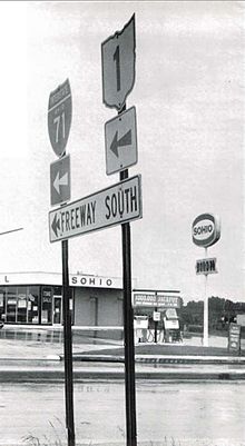
Much of Interstate 71 in Ohio was intended to be State Route 1. State Route 1 was originally planned in the 1950s as a second Ohio Turnpike extending southwest to northeast across the state. It was planned to run from Cincinnati to Conneaut and connect with an extension built across the panhandle of Pennsylvania to the New York State Thruway. As the highway was being planned, the Federal Aid Highway Act of 1956 was enacted, and the project was converted from a toll road to a freeway. It was designated as State Route 1, since the Interstate Highway numbering system had not yet been implemented. Portions of the freeway began to be completed and opened in 1959 with the new Interstate Highway funding, and they were marked as State Route 1 as well as with their new Interstate Highway number. Since large gaps existed along the corridor where no freeway had yet been completed, existing two-lane or four-lane highways were also designated as State Route 1 in order to complete the route. The State Route 1 signage was removed in 1966 as the Interstate Highway numbers adequately marked the route by then and the state highway numbering was superfluous.
In Columbus, the portion of Interstate 71 that bounds Worthington's eastern edge was originally called the North Freeway. Costing US$13.8 million, it was constructed south from Route 161, arriving at 11th Avenue by August 1961. It took another year to construct the portion between 11th Avenue and 5th Avenue, mainly due to the need to construct a massive underpass under the Pennsylvania Railroad's Grogan Yard. Today, only two tracks cross the viaduct, and the rest of the structure supports a large, weedy field. By August 1962, the freeway had reached Fifth Avenue, and it reached downtown in November 1962.
Interstate 71 was originally planned to follow the Innerbelt Freeway northward from its current northern terminus to the Cleveland Memorial Shoreway at Dead Man's Curve when Interstate 90 was planned to continue westward from there along the Shoreway.[5]
Upon its completion, I-71 replaced State Route 3 as the primary highway link between Cincinnati, Columbus, and Cleveland.
Between 2004 and 2006, the interchange at milepost 121 in the far northern reaches of Columbus was reconstructed to allow access to the eastern extension of Gemini Place.[6] Before that, it was a simple diamond interchange with Polaris Parkway (Ohio State Route 750).
Rebuilding and widening program[]
In 1999, the state of Ohio began a 10-year, $500 million project to improve I-71 between Columbus and Cleveland. The plans did not include widening the 25-mile stretch in Delaware and Morrow counties, calling for patching that section instead. At that time, state transportation officials said they didn't plan to widen that section for two reasons: Traffic studies didn't support the widening, and there was no money for the project.[7] But ODOT officials eventually gave in under pressure from elected officials and business owners to widen the remaining 25-mile stretch of I-71 from just north of the U.S. 36/Ohio 37 interchange in Delaware County to the Morrow/Richland county line.[8] The reconstruction and widening on the last 25-mile stretch of I-71 in Delaware and Morrow counties began in spring 2012 and the work was completed in summer 2015 at a cost of $144 million.[8]
Exit list[]
| State | County | Location | mi[1][2] | km | Exit | Destinations | Notes | |
|---|---|---|---|---|---|---|---|---|
| Kentucky | Jefferson | Louisville | 0.000 | 0.000 | Southern terminus; I-65 exit 137 | |||
| 136C | Jefferson Street – Downtown | Exit number follows I-65; southbound exit and northbound entrance | ||||||
| 1 | Signed as exits 1A (I-64) and 1B (I-65) southbound; no exit numbers northbound; I-64 exit 6; I-65 exit 137 | |||||||
| — | Northbound exit and southbound entrance; I-64 exit 5A | |||||||
| 1.724 | 2.775 | 2 | Zorn Avenue | |||||
| 4.966 | 7.992 | 5 | I-264 exits 23A-B; tri-stack interchange | |||||
| 9.063 | 14.585 | 9 | Signed as exits 9A (south) and 9B (north); I-265 exits 35A-B | |||||
| Oldham | | 14.488 | 23.316 | 14 | ||||
| | 17.478 | 28.128 | 17 | |||||
| | 18.507 | 29.784 | 18 | |||||
| La Grange | 21.869 | 35.195 | 22 | |||||
| Henry | Pendleton | 27.840 | 44.804 | 28 | ||||
| Campbellsburg | 33.505 | 53.921 | 34 | |||||
| Trimble |
No major junctions | |||||||
| Carroll | | 42.802 | 68.883 | 43 | ||||
| | 44.312 | 71.313 | 44 | |||||
| Gallatin | | 54.980 | 88.482 | 55 | Serves Kentucky Speedway | |||
| | 56.673 | 91.206 | 57 | |||||
| Glencoe | 61.774 | 99.416 | 62 | |||||
| Boone | | 72.195 | 116.187 | 72 | ||||
| | 77.724 | 125.085 | 77 | South end of I-75 overlap; exit numbers switch to follow I-75's mileposts, I-75 exit 173. | ||||
| | 79.556 | 128.033 | 175 | |||||
| Florence | 82.275 | 132.409 | 178 | |||||
| 84.298 | 135.664 | 180 | ||||||
| 84.694 | 136.302 | 180A | Mall Road | Southbound exit and northbound entrance; serves Florence Mall; former | ||||
| 85.449 | 137.517 | 181 | ||||||
| 86.652 | 139.453 | 182 | ||||||
| Kenton | Erlanger | 87.967 | 141.569 | 184 | Signed as exits 184A (east) and 184B (west) southbound | |||
| 88.900 | 143.071 | 185 | I-275 exit 84. | |||||
| Fort Mitchell | 90.539 | 145.708 | 186 | |||||
| 91.913 | 147.920 | 188 | ||||||
| Fort Wright | 92.870 | 149.460 | 189 | |||||
| Covington | 94.707– 94.858 | 152.416– 152.659 | 191 | 12th Street (), Pike Street (US 25 / US 42 / US 127) – Covington | ||||
| 95.414– 95.507 | 153.554– 153.704 | 192 | 5th Street (KY 8) – Covington, Newport | |||||
| Ohio River | 97.42 0.00 | 156.78 0.00 | Brent Spence Bridge Kentucky–Ohio line | |||||
| Ohio | Hamilton | Cincinnati | 0.22– 0.50 | 0.35– 0.80 | — | North end of I-75 overlap; south end of US 50 overlap | ||
| 1B | Second Street – Downtown, Riverfront | Exit unnumbered until 2018 | ||||||
| 1.11 | 1.79 | — | North end of US 50 overlap; northbound exit and southbound entrance | |||||
| Lytle Tunnel Sharp turn (40 mph or 64 km/h) in both directions | ||||||||
| 1.99 | 3.20 | 1A | Southbound exit and northbound entrance; exit unnumbered until 2018 | |||||
| 2.33– 2.48 | 3.75– 3.99 | 2 | Split into exits 2A (US 42) and 2B (Gilbert/8th) southbound; Gilbert Ave./8th St. not signed northbound, Eden Park Dr. not signed southbound | |||||
| 3.33– 4.3 | 5.36– 6.9 | McMillan Street | Northbound entrance only | |||||
| 3A | William Howard Taft Road | Southbound exit only | ||||||
| 3B | Signed as exit 3 northbound | |||||||
| 4.46– 6.03 | 7.18– 9.70 | 5 | Dana Avenue / Montgomery Road (US 22 / SR 3) | |||||
| Norwood | 6.75– 6.96 | 10.86– 11.20 | 6 | |||||
| Cincinnati | 8.04 | 12.94 | 8A | Ridge Avenue south | Northbound exit and southbound entrance | |||
| 8B | Signed as exit 7 southbound | |||||||
| Columbia Township | 8.51 | 13.70 | 8C | Ridge Avenue north | Northbound exit and southbound entrance | |||
| 8.75 | 14.08 | 8 | Kennedy Avenue, Ridge Avenue | Southbound exit and northbound entrance | ||||
| 9.91– 9.92 | 15.95– 15.96 | 9 | Red Bank Road – Fairfax | |||||
| Silverton | 10.68 | 17.19 | 10 | Stewart Road | Northbound exit and southbound entrance | |||
| Sycamore Township | 11.81 | 19.01 | 11 | Kenwood Road | Northbound exit and southbound entrance | |||
| 12.44 | 20.02 | 12 | ||||||
| Montgomery | 14.13 | 22.74 | 14 | |||||
| 15.80 | 25.43 | 15 | Pfeiffer Road | |||||
| 17.51– 17.54 | 28.18– 28.23 | 17 | I-275 exit 49 eastbound & 49A-B westbound; signed as exits 17A (east) & 17B (west) southbound | |||||
| Hamilton–Warren county line | Symmes–Deerfield township line | 19.88– 19.97 | 31.99– 32.14 | 19 | Mason Montgomery Road / Fields Ertel Road | |||
| Warren | Mason | 23.53 | 37.87 | 24 | Western Row Road / Kings Island Drive / Innovation Way – Kings Island | Signed as Western Row Road and Kings Island Drive northbound and Western Row Road and Innovation Way southbound; originally constructed as northbound exit and southbound entrance only but expanded to a full intersection in 2019[9] | ||
| 25.30 | 40.72 | 25 | ||||||
| Lebanon–South Lebanon city line | 28.33 | 45.59 | 28 | |||||
| Turtlecreek Township | 32.56 | 52.40 | 32 | |||||
| Washington Township | 36.74 | 59.13 | 36 | Wilmington Road | ||||
| Clinton | Chester Township | 45.11 | 72.60 | 45 | ||||
| Liberty Township | 50.74– 50.75 | 81.66– 81.67 | 50 | |||||
| Greene | Jefferson Township | 58.01 | 93.36 | 58 | ||||
| Fayette | Octa | 65.33 | 105.14 | 65 | ||||
| Jeffersonville | 69.49 | 111.83 | 69 | |||||
| Paint Township | 75.03 | 120.75 | 75 | |||||
| Madison | Pleasant Township | 84.27 | 135.62 | 84 | ||||
| Pickaway |
No major junctions | |||||||
| Franklin | Pleasant Township | 94.15 | 151.52 | 94 | ||||
| Jackson Township | 97.16 | 156.36 | 97 | Interchange fully opened August 17, 2012[10] | ||||
| Grove City | 98.85 | 159.08 | 99 | Hoover Road – Grove City | Proposed | |||
| 100.60 | 161.90 | 100 | Stringtown Road – Grove City | |||||
| Jackson Township | 101.68 | 163.64 | 101 | Signed as exits 101A (east) & 101B (west) northbound; I-270 exits 55A-B | ||||
| Columbus | 103.86 | 167.15 | 104 | |||||
| 105.43 | 169.67 | 105 | Greenlawn Avenue | |||||
| 106.33 | 171.12 | 106A | Northbound exit and southbound entrance; I-70 exit 99A | |||||
| 106B | No exit number southbound; I-70 exit 99B | |||||||
| — | Southbound exit and northbound entrance; south end of I-70 overlap; I-70 exit 99A; exit numbers switch to follow I-70's mileposts | |||||||
| New interchange to replace exits 100A-B; to have no southbound exit | ||||||||
| 107.07– 107.17 | 172.31– 172.47 | 100A | No northbound entrance; southbound exit is via exit 100B | |||||
| 107.41 | 172.86 | 100B | ||||||
| 107.90– 108.10 | 173.65– 173.97 | 101B | Parsons Avenue | Northbound exit only | ||||
| 107 | Left exit southbound; north end of I-70 overlap; I-70 exit 101A | |||||||
| 108.20 | 174.13 | 108A | Main Street | No northbound exit | ||||
| 108.63 | 174.82 | 108B | Southbound entrance and northbound exit | |||||
| 109.16 | 175.68 | 109A | Northbound exit and southbound entrance; I-670 exit 5; northbound off-ramp to I-670 east includes direct ramp onto Leonard Avenue | |||||
| 108.93 | 175.31 | 109B | Spring Street – Downtown | Southbound exit and northbound entrance | ||||
| 109.61 | 176.40 | 109A | Southbound exit and northbound entrance; I-670 exit 5 | |||||
| 110.16 | 177.29 | 110A | Fifth Avenue | No northbound exit | ||||
| 110.68 | 178.12 | 110B | Access to Linden Primary Care Center | |||||
| 111.15 | 178.88 | 111 | 17th Avenue | Access to the Ohio State Fairgrounds & Expo Center, Ohio History Center, and MAPFRE Stadium | ||||
| 112.33 | 180.78 | 112 | Hudson Street | Access to MAPFRE Stadium | ||||
| 112.98 | 181.82 | 113 | Weber Road | |||||
| 113.46 | 182.60 | 114 | North Broadway | Access to Riverside Methodist Hospital | ||||
| 114.53 | 184.32 | 115 | Cooke Road | |||||
| 115.58 | 186.01 | 116 | Morse Road / Sinclair Road | |||||
| 117.53 | 189.15 | 117 | ||||||
| 119.21– 119.23 | 191.85– 191.88 | 119 | Signed as exits 119A (east) and 119B (west) southbound; I-270 exit 26 westbound, 26A-B eastbound. | |||||
| Franklin–Delaware county line | 121.45– 121.92 | 195.45– 196.21 | 121 | Eastern terminus of SR 750; access to Polaris Shopping Center | ||||
| Delaware | Berkshire Township | 130.64 | 210.24 | 131 | ||||
| Morrow | Bennington Township | 140.15 | 225.55 | 140 | ||||
| Chester–Franklin township line | 151.09 | 243.16 | 151 | |||||
| Richland | Washington Township–Bellville village line | 165.25 | 265.94 | 165 | ||||
| Washington Township–Mansfield city line | 168.81 | 271.67 | 169 | |||||
| Madison Township | 172.97 | 278.37 | 173 | |||||
| Mifflin Township | 176.91 | 284.71 | 176 | Indirect southbound access to eastbound US 30 and from westbound US 30 to northbound Interstate 71 via Crider and Koogle roads | ||||
| Black Fork Mohican River | Bridge | |||||||
| Ashland | Montgomery Township | 186.71 | 300.48 | 186 | ||||
| Wayne | Congress Township | 196.31 | 315.93 | 196 | Northbound exit and southbound entrance | |||
| 197.92 | 318.52 | 198 | ||||||
| Medina | Harrisville Township | 203.89 | 328.13 | 204 | ||||
| Westfield Township | 209.51 | 337.17 | 209 | Signed as exits 209A (I-76/US 224 east) and 209B (US 224 west); western terminus of I-76 (Ohio), exit 1 eastbound, 1A-B westbound | ||||
| Medina Township | 218.86 | 352.22 | 218 | |||||
| 220.71 | 355.20 | 220 | Northbound exit and southbound entrance | |||||
| 222.91 | 358.74 | 222 | ||||||
| Brunswick | 226.03 | 363.76 | 226 | |||||
| Cuyahoga | Strongsville | 231.26 | 372.18 | 231 | Signed as exits 231A (east) and 231B (west) southbound | |||
| 233.06 | 375.07 | 233 | I-80/OH Turnpike exit 161 | |||||
| Middleburg Heights | 234.21 | 376.92 | 234 | |||||
| 235.37 | 378.79 | 235 | Bagley Road – Berea, Middleburg Heights | |||||
| Brook Park | 237.53 | 382.27 | 237 | Signed as exits 237A (east) and 237B (west, Engle) southbound | ||||
| Brook Park–Cleveland line | 238.77 | 384.26 | 238 | I-480 exit 11; northbound exit and southbound entrance | ||||
| Cleveland | 239.26 | 385.05 | 239 | Southbound left exit and northbound left entrance | ||||
| 240.57 | 387.16 | 240 | W. 150th Street | |||||
| 241.85 | 389.22 | 242A | W. 130th Street | Signed as exit 242 southbound | ||||
| Cleveland–Linndale line | 242.41 | 390.12 | 242B | Bellaire Road | Northbound exit and southbound entrance | |||
| Cleveland | 244.5 | 393.5 | 244 | Denison Avenue / W. 65th Street | Northbound exit and southbound entrance | |||
| 245.48– 246.20 | 395.06– 396.22 | 245 | ||||||
| 246.6 | 396.9 | 246 | Southbound exit and northbound entrance | |||||
| 246.98– 247.56 | 397.48– 398.41 | 247A-B | Northbound exit and southbound entrance; I-90 exit 170B; I-490 exit 1A | |||||
| 247.81– 248.15 | 398.81– 399.36 | Northern terminus; I-90 exit 170B | ||||||
1.000 mi = 1.609 km; 1.000 km = 0.621 mi
| ||||||||
Auxiliary routes[]
- I-471 - links downtown Cincinnati with Interstate 275
- I-271 - provides access to Cleveland's eastern suburbs and enables travelers on Interstate 71 to access Interstate 90 east without going through Cleveland proper.
See also[]
- Carrollton bus disaster, a drunk-driving tragedy involving a school bus that occurred on I-71
- Roads in Louisville, Kentucky
- Sports rivalries involving cities on I-71
- Battle of Ohio: Cincinnati Bengals–Cleveland Browns (NFL)
- Crosstown Shootout: Cincinnati Bearcats–Xavier Musketeers (college basketball)
- The Keg of Nails: Cincinnati Bearcats–Louisville Cardinals (college football)
- Ohio Cup: Cincinnati Reds–Cleveland Indians (MLB)
- Hell Is Real Derby: Columbus Crew SC–FC Cincinnati (MLS)
References[]
- ^ Jump up to: a b Kentucky Transportation Cabinet, HIS Expanded Milepoint Route Log Extract Archived 2007-11-09 at the Wayback Machine, updated October 31, 2007
- ^ Jump up to: a b Ohio Department of Transportation Office of Technical Services: Straight Line Diagrams Archived 2003-02-19 at the Wayback Machine, current as of January 1, 2007
- ^ "Route Log and Finder List: Table 1 - Interstate System". FHWA. Retrieved 2007-07-09.
- ^ Kleber, John E., ed. (2001). Encyclopedia of Louisville. p. 418. ISBN 0813128900.
- ^ Ohio Department of Highways. "1957-1958 Biennial Report (excerpt)". Retrieved 2013-02-27.
- ^ urbanohio.com. "Ohio Fuses Two Interchanges in Columbus". Retrieved 2015-06-14.
- ^ Mark Ferenchik. "The Columbus Dispatch - 3rd lane coming to I-71 by 2015". The Columbus Dispatch. Retrieved 4 October 2014.
- ^ Jump up to: a b Todd Hill. "MansfieldNewsJournal - I-71 widening almost finished". Mansfield News Journal. Retrieved 2015-06-19.
- ^ Smith, Lisa (February 1, 2019). "Will it soon be easy to get off (and then back on) I-71 at Western Row?". WCPO. Retrieved February 3, 2019.
- ^ "Transportation Partners Celebrate Opening of New Southern Gateway" (Press release). Ohio Department of Transportation District 6. 2012-08-16. Retrieved 2013-02-27.
External links[]
Route map:

| ( • help)
|
| Wikimedia Commons has media related to Interstate 71. |
- I-71 on Cincinnati-Transit.net
- Interstate-guide.com: Interstate 71
- Historic photos: 1963 aerial view of I-71 construction between 17th and 5th avenues in Columbus, Ohio Gasoline tanker crash and fire collapses Cleveland Avenue overpass in Columbus, Ohio 6/28/1966 Rebuilding the Cleveland Avenue overpass after it was destroyed by a gasoline tanker fire in 1966
| show |
|---|
| Authority control: National libraries |
|---|
- Interstate 71
- Interstate Highway System
- Interstate Highways in Kentucky
- Interstate Highways in Ohio
- Transportation in Louisville, Kentucky
- Roads in Cincinnati
- Transportation in Columbus, Ohio
- Transportation in Cleveland
- Transportation in Jefferson County, Kentucky
- Transportation in Oldham County, Kentucky
- Transportation in Henry County, Kentucky
- Transportation in Trimble County, Kentucky
- Transportation in Carroll County, Kentucky
- Transportation in Gallatin County, Kentucky
- Transportation in Boone County, Kentucky
- Transportation in Kenton County, Kentucky
- Transportation in Hamilton County, Ohio
- Transportation in Warren County, Ohio
- Transportation in Clinton County, Ohio
- Transportation in Greene County, Ohio
- Transportation in Fayette County, Ohio
- Transportation in Madison County, Ohio
- Transportation in Franklin County, Ohio
- Transportation in Delaware County, Ohio
- Transportation in Morrow County, Ohio
- Transportation in Richland County, Ohio
- Transportation in Ashland County, Ohio
- Transportation in Wayne County, Ohio
- Transportation in Medina County, Ohio
- Transportation in Cuyahoga County, Ohio