List of future Interstate Highways
| Dwight D. Eisenhower National System of Interstate and Defense Highways | |
|---|---|
  Shields for future Interstates | |
 Proposed Interstate Highways in December 2015 | |
| System information | |
| Formed | June 29, 1956[1] |
| Highway names | |
| Interstates | Interstate X (I-X) |
| System links | |
In the United States, future Interstate Highways include proposals to establish new mainline (one- and two-digit) routes to the Interstate Highway System. Excluded from this article are auxiliary Interstate Highways (designated by three-digit numbers) in varying stages of planning and construction, and the planned expansion of existing primary Interstate Highways.
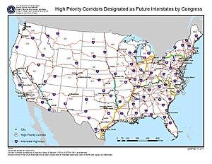
Congressionally designated future Interstates[]
Several Congressional High Priority Corridors have been designated as future parts of the Interstate Highway System by the Intermodal Surface Transportation Efficiency Act and amendments. By law, they will become interstates when built to Interstate standards and connected to other interstates.[2][3]
Interstate 3[]
Future Interstate 3 | |
|---|---|
| Location | Savannah, GA – Knoxville, TN |
Interstate 3 is the proposed designation of an Interstate Highway Corridor under development in the Southeastern United States. It is planned to run from Savannah, Georgia, to Knoxville, Tennessee. Its number does not follow standard numbering conventions; under established numbering conventions, I-3 would normally run west of I-5 along the Pacific Coast. The unnumbered Interstate was established by the Safe, Accountable, Flexible, Efficient Transportation Equity Act: A Legacy for Users (SAFETEA-LU) legislation that also provided for Interstate 14. The "Interstate 3" designation has not been officially accepted by American Association of State Highway and Transportation Officials (AASHTO) or the Federal Highway Administration (FHWA), but is being used by the Georgia Department of Transportation and others to identify the highway. The number comes from the 3rd Infantry Division which is based in Georgia. Portions of the planned route, including the Savannah River Parkway, are already built to Interstate standards; the exact route has not been finalized, especially across the Appalachian Mountains northwest of Augusta, Georgia.[citation needed]
Interstate 7 or 9[]
Future Interstate 7 | |
|---|---|
| Location | Wheeler Ridge–Sacramento, CA |
Future Interstate 9 | |
|---|---|
| Location | Wheeler Ridge–Sacramento, CA |
Interstate 7 or Interstate 9 has been proposed by Caltrans for State Route 99 in central California. It would go from the split with I-5 at Wheeler Ridge (Wheeler Ridge Interchange) north through Bakersfield and Fresno to Stockton, where the proposed route turns west via the State Route 4 freeway to a terminus at I-5 in the central part of that city. An alternate proposed terminus is located at the I-5/US 50/Capital City Freeway junction in Sacramento, where the future Interstate, after continuing north from Stockton along Route 99, can turn west along the Capital City Freeway, already an Interstate route (unsigned I-305), to connect with I-5, which extends north toward Redding. This also serves as a connector to the existing northern portion of Highway 99. The future Interstate's prospects for development to appropriate standards are tied to the Caltrans "Route 99 Corridor Enhancement Master Plan", which outlines improvements to that route, including capacity and physical improvements; this document posits that when and if Interstate status is conferred, the route will be designated either I-7 or I-9.[4]
In August 2005, with the passage of that year's SAFETEA-LU federal transportation legislation, SR 99 from Wheeler Ridge to Stockton and beyond to Sacramento was designated as High Priority Corridor 54, the California Farm-to-Market Corridor; this legislation also designated that corridor as a future segment of the Interstate System.[5]
Interstate 42[]
Interstate 42 | |
|---|---|
| Location | Garner, NC – Morehead City, NC |
| Length | 142 mi (229 km) |
The Fixing America's Surface Transportation Act (FAST Act) added the US 70 corridor between Garner and Morehead City, North Carolina, to the Interstate system by defining it as, first, High Priority Corridor #82 and subsequently designating it as a future Interstate.[6] The Regional Transportation Alliance expected this corridor to be called Interstate 46 or another suitable designation.[7] At a meeting in La Grange, North Carolina, on March 17, 2016, the Super 70 Corridor Commission recommended that the designation of Interstate 50 be sought for the US 70 Interstate corridor. The rationale for the I-50 numerical selection was cited as a number not in conflict with either an existing Interstate designation or currently applied to a U.S. Highway within North Carolina.[8] This recommendation was forwarded to NCDOT for submission to AASHTO.
For the AASHTO Special Committee on U.S. Route Numbering meeting in May 2016, NCDOT proposed I-36 for this route.[9] However, AASHTO instead designated the route as Interstate 42.[10][11]
Other proposals[]
Interstate 67[]
Future Interstate 67 | |
|---|---|
| Location | Indianapolis, IN – Grand Rapids, MI; Elkhart, IN – Kalamazoo, MI; Bowling Green, KY – Owensboro, KY – Crane, IN |
Interstate 67 has been a proposed number for at least three highways.
Indiana has proposed using the I-67 designation for the freeway upgrade of US 31 currently under construction between Indianapolis and South Bend, possibly continuing northward via the US 31 freeway to Benton Harbor, Michigan, and going northward from there along existing I-196 to Grand Rapids. The Indiana Senate unanimously passed a resolution calling for federal funding for this proposal and the I-67 designation in 2003.[12] Meanwhile, Indiana expedited the upgrading of three major sections on US 31 between Indianapolis and South Bend including the Kokomo Bypass. This was done using funds received through the 2006 Major Moves deal. Such a proposal would put I-67 in the proper place in the grid (it is the only number available for that route).
I-67 was originally the designation given to a never-built highway connecting Kalamazoo, Michigan, to the east side of Elkhart, Indiana, as part of the original Interstate numbering plan in 1957.[13] A planning map shows a freeway along this routing intersecting the Indiana Toll Road just west of the State Road 19 interchange.[14] The Michigan State Highway Department officially requested switching the I-67 designation to a route from Benton Harbor to Grand Rapids in 1958, and in the process proposed the northerly extension of the original I-69 from the I-80/I-90/Indiana Toll Road to Lansing.[15] The I-67 designation was denied by the American Association of State Highway and Transportation Officials which then assigned I-196 to the Benton Harbor to Grand Rapids route, west of the I-96 junction near Grand Rapids.[16]
A third, much shorter, proposal in 2011 by the I-67 Development Corporation from the Owensboro, Kentucky, area involves continuing the proposed I-67 in Indiana along a route parallel to US 231 from Crane, Indiana, to Bowling Green, Kentucky. Much of the proposed route already exists and is close to Interstate grade. Only the northern third from Dale, Indiana, to Crane remains unfinished. It would use the Natcher Bridge to cross the Ohio River, Kentucky's Interstate-grade Natcher Parkway and Indiana's Lincoln Parkway, an expressway facility that would need to be fully upgraded to Interstate standards. It would go around the cities of Jasper and Huntingburg in Indiana as well as Owensboro, Hartford, and Morgantown, Kentucky, and end at Bowling Green. It could also be linked to the first proposal by overlapping I-67 with the currently under construction I-69 from Indianapolis to Crane.[17]
Interstate 92[]
Future Interstate 92 | |
|---|---|
| Location | Albany, NY – Portsmouth, NH or Glens Falls, NY – Calais, ME |
As originally proposed by the Michigan State Highway Department in 1957, I-94 from Benton Harbor to Detroit would have been numbered Interstate 92. Since then, I-92 has been a proposed number for at least two highways.
Low population and natural barriers like the White Mountains have impeded economic development in northern New England. In the early 1970s, Maine, New Hampshire, Vermont and New York proposed two new Interstate Highway corridors:
- From Albany, New York, to Portsmouth, New Hampshire, incorporating the current route whose easternmost segment is New Hampshire Route 101.
- From Glens Falls, New York, to Calais, Maine (designated as I-92 and potentially linking to New Brunswick Route 1 near Calais, Maine), tracing U.S. Route 4 eastward through Vermont and New Hampshire.
The Federal Highway Administration ultimately did not approve these plans.
Northern New England is served by three north–south freeways radiating from Boston and by Interstate 91, which follows the Connecticut River. However, the northernmost complete east–west freeway in the region, Interstate 90 in Massachusetts, does not enter northern New England. East–west travel through northern New England is facilitated by three freeway segments:
- Interstate 89 between Montpelier, Vermont, and Burlington.
- US 4 west of Rutland, Vermont.
- New Hampshire Route 101 from Manchester, New Hampshire, eastward to the ocean.
Maine Senator Olympia Snowe said in 2004 that the region is disadvantaged by the fact that it was the only region in the US for which a federal High Priority Corridor was not designated in the 1991 Intermodal Surface Transportation Efficiency Act.[18] In 2012, the east–west highway was again proposed, this time as a privately financed toll road.[19]
Current backers of the highway propose an east–west axis through northern and central Maine, with three potential freeway links with Canada—two from Québec, and one from New Brunswick. One portion of the new highway would run from Interstate 395 in Brewer, Maine, to the Canadian border near Calais, with a direct link to New Brunswick Route 1, a major transportation corridor serving the Maritimes. A second would travel northwest from Interstate 95 near Waterville, Maine, to the Canadian border at Coburn Gore, with a connection to a proposed extension of Quebec Autoroute 10 toward Montreal. A third would travel due west from I-95 near Waterville, following the U.S. Route 2 corridor through Maine, New Hampshire, Vermont, and northern New York, with Quebec's Autoroute 73 having a southeasterly oriented southern end that heads for the Armstrong-Jackman Border Crossing, as Quebec Route 173 already reaches the United States at the same port of entry.
Interstate 98[]
Future Interstate 98 | |
|---|---|
| Location | Watertown, NY – Swanton, VT |
As originally proposed by the Michigan State Highway Department in 1958, I-696 would have been numbered Interstate 98.[15] Since then, another highway in Upstate New York and Vermont has been linked to the number. Plans for the Rooftop Highway, a proposed limited-access highway that would extend for 175 miles (282 km) from Watertown, New York, to Swanton, Vermont, which I-89 travels through (at exit 21), first surfaced in the 1950s. If built, the highway would likely follow the US 11 corridor across the northern part of New York's North Country, connecting I-81 to I-89.[citation needed]
A study called the North Country Transportation Study Action Plan and Final Technical Report suggests that the road would likely be built to Interstate Highway standards in order to improve constrained transit systems due to a lack of infrastructure throughout the area. Backers of the project have called for the highway to be designated as I-98;[20] however, this designation has not been recognized by any government agencies, such as NYSDOT or the AASHTO. The number does fit into AASHTO's numbering system, though, as the highest even numbers are designated for highways running along the Canadian border, such as the proposed highway.[21]
The Northern Corridor Transportation Group (NCTG) was formed in December 2008 as a means of refocusing the fifty-year discussion on the project. Since that time, more than 100 municipal and civic resolutions from the five northern counties of New York have been passed in support of the construction of the project. On July 16, 2009, the NCTG submitted a request to U.S. Senator Kirsten Gillibrand to direct $800 million toward the project as part of the reauthorization of a federal highway transportation bill. In a historic move, the six northern legislators representing the North Country in the New York State Legislature (Senators Aubertine, Griffo and Little and Assembly Members Scozzafava, Russell and Duprey) signed an official letter of request to the same end.[citation needed]
Interstate 99[]
Interstate 99 | |
|---|---|
| Location | Wilson, NC–Christiana, DE |
In 2006, the Virginia General Assembly directed the Secretary of Transportation to initiate a study to determine the interest of affected states in the construction of a new Interstate highway (I-99).[22][23][24] I-99 would allow long-distance travelers to bypass the I-95 bottleneck in the Baltimore–Washington metropolitan area. This would be separate from the existing Interstate 99 in New York and Pennsylvania.
I-99 would travel from I-95 in Wilson, North Carolina, to another point on I-95 in Christiana, Delaware (12 miles (19 km) from Wilmington, Delaware). It would renumber the controlled access Delaware Route 1 (DE 1) and would parallel U.S. Route 13 (US 13) through the Delmarva Peninsula and using the existing Chesapeake Bay Bridge–Tunnel. It would travel through Norfolk, Virginia, traveling concurrently with existing interstates where possible. I-99 would continue to travel parallel to US 13 until it enters North Carolina, where it would travel parallel to US 258 until ending on I-95 in Wilson.[23]
Another option is for I-99 to parallel US 17 in North Carolina, and have it end in Charleston, South Carolina. One option that was never fully planned was to connect the proposed Christiana, Delaware, I-99 east coast section and existing Bedford, Pennsylvania, I-99 section by having I-99 travel concurrently with existing interstates including I-476 and I-76.[23]
See also[]
 U.S. Roads portal
References[]
- ^ Weingroff, Richard F. (Summer 1996). "Federal-Aid Highway Act of 1956, Creating the Interstate System". Public Roads. Washington, DC: Federal Highway Administration. 60 (1). Retrieved March 16, 2012.
- ^ United States Congress. "National Highway System Designation Act of 1995". Library of Congress. Archived from the original on September 4, 2015. Retrieved October 21, 2007.
- ^ Staff (May 2, 2006). "Future Interstates on the National Highway System Designated by Section 1105 of ISTEA as amended". Federal Highway Administration. Archived from the original on September 26, 2006.
- ^ "Chapter 3" (PDF). Caltrans Route 99 Enhancement Plan (PDF). California Department of Transportation.
Interstate designation, under the current proposal, would apply to the 260-mile (420 km) segment between the junction of State Route 99 with I-5 south of Bakersfield to I-5 in Stockton using State Route 4 as the connector to I-5. Since there is an I-99 route currently in existence in Pennsylvania, it is anticipated that should designation be granted, the Route 99 designation would become I-7 or I-9 to satisfy Interstate numbering convention.
- ^ United States Congress. "Safe, Accountable, Flexible, Efficient Transportation Equity Act: A Legacy for Users". Library of Congress.
- ^ https://www.congress.gov/114/bills/hr22/BILLS-114hr22enr.pdf#page=111
- ^ "A victory ten years in the making". RTA.
- ^ Wilson, Marcia R. (March 17, 2016). "Minutes and Summary" (PDF). La Grange, NC: Highway 70 Corridor Commission of North Carolina. Archived from the original (PDF) on June 23, 2016. Retrieved April 7, 2016.
- ^ "AASHTO Electronic Balloting System, View Ballot, Agenda and List of Applications, SM-2016" (PDF). AASHTO. Archived from the original (PDF) on June 10, 2016. Retrieved May 5, 2016.
- ^ Special Committee on U.S. Route Numbering (May 24, 2016). "Special Committee on U.S. Route Numbering" (PDF) (Report). Washington, DC: American Association of State Highway and Transportation Officials. Archived (PDF) from the original on December 16, 2017. Retrieved May 26, 2016.
- ^ Siceloff, Bruce (May 25, 2016). "Future interstate highway names approved". News & Observer. Retrieved May 25, 2016.
- ^ "Zakas' Resolution Passes Senate Unanimously; Bill supports efforts of Indiana Congressional Delegation to seek federal funding for US 31 freeway project" (Press release). State of Indiana Senate District 11. Archived from the original on March 11, 2007. Retrieved July 6, 2009.
- ^ Public Roads Administration (August 14, 1957). Official Route Numbering for the National System of Interstate and Defense Highways (Map). American Association of State Highway Officials – via Wikimedia Commons.
- ^ "FAI9 1957". Indiana Interstates: 1957 Interstate Highway System. Archived from the original on June 23, 2002. Retrieved May 7, 2008.
- ^ Jump up to: a b Staff (April 25, 1958). Recommended Interstate Route Numbering for Michigan (Report). Michigan State Highway Department. Archived from the original on August 5, 2004. Retrieved September 4, 2010.
- ^ "Would Shift Route Number: Mackie Seeks Int. 96 Designation for Grand Rapids–Muskegon Stretch". The Grand Rapids Press. May 1, 1963. p. 31. OCLC 9975013.
- ^ GO-EDC (January 13, 2012). "Facts about Interstate 67 as Owensboro's interstate". Owensboro Economic Development Blog. Greater Owensboro Economic Development Corporation. Retrieved October 10, 2012.
- ^ Senator (June 25, 2004). "East–West Highway Will Connect Mainers to All Points In-Between and Beyond". Weekly Senate Update. Archived from the original on July 1, 2011.
- ^ "Transportation Committee passes bill for east-west highway study". Bangor Daily News. Retrieved February 18, 2012.
- ^ "It's now I-98, not Rooftop Highway". Adirondack Daily Enterprise. Saranac Lake, NY. August 1, 2009. Retrieved February 2, 2011.
- ^ "Is there any rhyme or reason to how U.S. interstate highways are numbered?". HowStuffWorks. June 12, 2001. Retrieved January 23, 2019.
- ^ Froggie; Mapmikey (May 2, 2010). "I-99". The Virginia Highways Project.[self-published source]
- ^ Jump up to: a b c Homer, Piere R. (November 2006). Construction of I-99: Report to the Chairmen of House Committees on Transportation and Appropriations and Senate Committees on Transportation and Finance (PDF). Richmond: Virginia Department of Transportation. Retrieved August 31, 2018.
- ^ Virginia Department of Transportation (January 2008). Interstate Compact: Report to the Division of Legislative Automated Systems (PDF). Richmond: Virginia Department of Transportation. Retrieved August 31, 2018.
External links[]
| hide | |
|---|---|
| Signed | |
| Unsigned | |
| Lists | |
| Other | |
Major Interstates highlighted | |
- Proposed Interstate Highways
- Lists of proposals