Interstate 89
This article needs additional citations for verification. (December 2019) |
 | |||||||||
|---|---|---|---|---|---|---|---|---|---|
I-89 highlighted in red | |||||||||
| Route information | |||||||||
| Length | 191.12 mi[1] (307.58 km) | ||||||||
| Existed | 1967–present | ||||||||
| Major junctions | |||||||||
| South end | |||||||||
| |||||||||
| North end | |||||||||
| Location | |||||||||
| States | New Hampshire, Vermont | ||||||||
| Counties | NH: Merrimack, Sullivan, Grafton VT: Windsor, Orange, Washington, Chittenden, Franklin | ||||||||
| Highway system | |||||||||
|
State highways in Vermont
| |||||||||

Interstate 89 (I-89) is an Interstate Highway in the New England region of the United States traveling from Bow, New Hampshire, to the Canadian border between Highgate Springs, Vermont, and Saint-Armand, Quebec. As with all odd-numbered primary interstates, I-89 is signed as a north–south highway. However, it follows a primarily northwest-to-southeast path. The route forms a substantial part of the main connection between the cities of Montreal and Boston. In Quebec the route continues as Quebec Route 133. The eventual completion of Autoroute 35 from Montreal will lead to a non-stop limited access highway route between the two cities, following I-93 south from I-89's terminus. The largest cities directly served by I-89 are Concord, the state capital of New Hampshire, Montpelier, the state capital of Vermont, and Burlington, Vermont. I-89 is one of three main Interstate highways whose route is located entirely within New England, along with I-91 and I-93 (both of which have their northernmost pavement in Vermont).
I-89 connects smaller cities and rural areas within New Hampshire and Vermont, and maintains two lanes of traffic in each direction throughout the route. Unlike its neighboring Interstates, it does not intersect any even-numbered Interstates along its route. It does, however, parallel (and intersect multiple times with) portions of three U.S. routes: U.S. Route 4 (US 4) from Enfield, New Hampshire, to Hartford, Vermont; US 2 from Montpelier to Colchester, Vermont, and US 7 from Burlington to the Canadian border. US 7 and US 2 overlap each other between Burlington and Colchester.
In Chittenden County, Vermont, Interstate 189, also known as the Champlain Parkway, begins from exit 13 in South Burlington and is proposed to be extended from its current terminus at US 7 as a link to downtown Burlington.[2] I-189 is the only auxiliary route of I-89.
Route description[]
| mi | km | |
|---|---|---|
| NH[3] | 60.864 | 97.951 |
| VT[4] | 130.254 | 209.623 |
| Total | 191.118 | 307.575 |
New Hampshire[]

Interstate 89 runs for about 60.6 miles (97.5 km) in the state of New Hampshire, and is the major freeway corridor through the western part of the state. Despite being signed as a north–south freeway, its first 8 miles (13 km) actually run east–west before shifting to the northwest. The two major population centers along I-89's length in New Hampshire are Concord, at its southern terminus, and Lebanon, on the Vermont state line. Mileage signs along I-89 in each direction consistently list one of the two cities. Also located along I-89 in New Hampshire are the towns of Grantham, New London and Warner.
Starting at an intersection with Interstate 93 and New Hampshire Route 3A in the town of Bow, just south of the New Hampshire capital city of Concord, the highway runs a northwest path through the Dartmouth–Lake Sunapee Region. One exit directly serves Concord (Exit 2) before the highway enters the neighboring town of Hopkinton. East–west New Hampshire Route 11 joins I-89 at Exit 11 and runs concurrently with it for about 3 miles (5 km) before departing at Exit 12. At Exit 13 in Grantham, New Hampshire Route 10 enters I-89, and the pair of highways form another concurrency, this one for about 15 miles (24 km).
Southeast of Lebanon, signs for Exit 15 display the name "Montcalm", while Exit 16 directs travelers to "Purmort". Neither place name existed at the time of construction of the Interstate. Exits 15 and 16 were built to access portions of the town of Enfield that were otherwise cut off by the new highway. The names were chosen by Enfield's selectmen in 1960; the Purmorts were a prominent local family in the early history of Enfield, and Montcalm was a nearby settlement that had once had its own school and post office.[5] While the Purmort exit does allow access to the state road network (specifically to US 4 via Eastman Hill Road), the Montcalm exit provides access to an otherwise isolated community; every public road from the exit is a dead end, and leaving the Montcalm area by car requires getting back on I-89 at Exit 15. However, a bicycle path parallels I-89 between Exits 14 and 16 along the path of Old Route 10, allowing foot or bicycle access to the community.
The highway continues northwest, passing through Lebanon, in which the Dartmouth-Hitchcock Medical Center is located. A few miles north of this point is Dartmouth College. U.S. Route 4 parallels I-89 through Lebanon. Exits 17 through 20 serve the city of Lebanon and are passed in quick succession. At Exit 19, northbound New Hampshire Route 10 separates from I-89 and joins westbound U.S. Route 4 to pass through West Lebanon. The final exit in New Hampshire is Exit 20, providing access to West Lebanon's large retail district along New Hampshire Route 12A. Just after this interchange, the highway crosses the Connecticut River and enters Vermont, where it remains for the rest of its run northwest to the Canadian border.
Vermont[]

Interstate 89 is one of Vermont's most important roads, as it is the only Interstate highway to directly serve both Vermont's capital city (Montpelier) and largest city (Burlington). Other important cities and towns located along I-89 are Barre, Waterbury, and St. Albans. Williston, which has become Burlington's big-box retail center (and one of the fastest-growing towns in the state) over the past decade, also has an interchange along I-89.
Crossing the Connecticut River into Vermont, I-89 continues the northwesterly direction it carried in New Hampshire. The Interstate intersects I-91 at an unnumbered interchange immediately upon entering Vermont. Shortly afterward, another interchange with U.S. 4 occurs. The highway begins to enter the scenic rolling hills of Vermont, turning almost due northward about 20 miles (32 km) from the New Hampshire state line, and continues through the high country of central Vermont. The Interstate passes through the towns of Sharon, Royalton, Bethel, Randolph, Brookfield, and Williamstown before reaching the "twin cities" of Barre and Montpelier in the middle of Vermont. The interstate's highest point was said to be in the town of Brookfield, although the sign that made the declaration was taken down in the late 1990s.
Another directional shift, again to the northwest, occurs while passing the interchange for Montpelier. For the next 40 miles (64 km), I-89's path is not so much chosen as it is logical: paralleling the Winooski River and U.S. Route 2, the highway cuts through the section of the Appalachians known as the Green Mountains, and is surrounded by peaks of over 4,000 feet (1,200 m): Camel's Hump to the south and Mount Mansfield to the north. U.S. 2 crosses the Interstate frequently, and has several interchanges with it, en route to Burlington.
Interstate 89 was unique due to one instance of its signage. Between (Vermont) Exits 9 & 10, a sign showing the distance to the next control cities in each direction was completely in metric. While there are many instances of signs being in both miles and kilometers, this was the only case of solely metric in the entire Interstate System.[6] Both signs were replaced in 2010 and show distances in miles only. (Interstate 19 in Arizona used to be the other "only signed in metric" interstate in the U.S., but has been changed over in recent years as the last 2 km have been changed.) Speed limit signs have always been posted in mph.

After Exit 11 in Richmond, I-89 leaves the Green Mountains to enter the Champlain Valley, and a notable shift in the landscape is visible. Here, just outside Burlington, the highway turns northward once again. Also, at this turn is where the only official auxiliary highway starts, Interstate 189. A second highway, Interstate 289, was proposed as a beltway through Burlington's northeastern suburbs in the 1980s; amidst controversy, the highway has only been partially completed as Vermont Route 289, a super two roadway. It has yet to directly meet its parent.
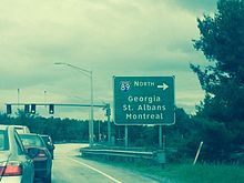
Passing I-189 at Exit 13, I-89 sees the busiest freeway interchange in the entire state, Exit 14. A full cloverleaf interchange at this exit provides access to downtown Burlington, the University of Vermont, and the retail-heavy Dorset Street, via U.S. 2. Heading north from Burlington, the landscape quickly fades from suburban development into rolling hills more characteristic of northern New England, providing a vista overlooking Lake Champlain. I-89 passes through Milton, Georgia, St. Albans, Swanton, and finally the border town of Highgate Springs. The highway ends at the Canadian border at the Highgate Springs–St. Armand/Philipsburg Border Crossing in Highgate Springs. Its final exit, which northbound motorists can use to reverse direction onto I-89 south without crossing the border, is exit 22—the highest exit number along the route. U.S. Route 7 has its northern terminus at this interchange as well.
Although the divided highway continues about 5 miles (8 km) into Philipsburg, Quebec, as Route 133, this changes back to a two-lane road, through to Autoroute 35's current southern terminus in Saint-Sébastien, some 15 km/9 miles north of the US/Canada border, and continues to Montreal.[7] The I-89 border crossing is the only instance where an Interstate entering Quebec does not become an Autoroute upon entry. There are plans to complete the extension of Autoroute 35 from Saint-Sébastien to the border crossing at I-89's northern terminus by 2023, creating a freeway-to-freeway connection.[8]
History[]
Construction[]
I-89 was commissioned as part of the Federal Aid Highway Act of 1956, meant to connect Norwalk, Connecticut, to the Canadian border via the US 7 corridor, which is the current northern terminus of I-89. Within three years, however, opposition to the project (particularly from Massachusetts, which desired a freeway connection from Boston to Montreal) shifted I-89 to its present alignment that connects Boston with Montreal. The first section of the highway was opened between Montpelier and Middlesex, Vermont, in November 1960, and between Middlesex and Waterbury in December 1960. The highway was subsequently opened between Waterbury and Bolton in November 1961; between South Burlington and Winooski in November 1962; between Winooski and Colchester and between Richmond and South Burlington in November 1963; between Bolton and Richmond in October 1964; in Colchester in November 1964; and between Swanton and Highgate in 1965. The Interstate was opened in most parts of New Hampshire in 1967, and the entirety of the route was opened in 1982.[9]
Original proposal[]
I-89 was originally supposed to be a directly north–south route from I-95 in Norwalk, Connecticut, to its current northern terminus at the Canadian border. The route shifted after opposition came from residents and local lawmakers in interior New England who did not want an Interstate running through their countryside and towns. One major problem that was a big part in sinking the project was the fact that the highway would have to go through the Green Mountain National Forest in Vermont.[10] Parts of the Interstate were built in Connecticut, between Norwalk and Wilton and from Brookfield to Danbury, a short bypass around Lenox, Massachusetts, and in southern Vermont between Bennington and Manchester and are currently designated as U.S. Route 7. The state of Connecticut had plans to extend the Norwalk segment to meet with the Danbury segment, but has instead opted to widen portions of the existing road to 4 lanes.[11] There has always been talk of building the original route of I-89, as it would bring economic development to cities like Pittsfield, Massachusetts, and Bennington, Vermont, and connect parts of the interior Northeast to New York City, but nothing has ever been formally proposed since the original proposal in the 1950s.[who said this?]
Other routes between Boston and Montreal[]
This section needs additional citations for verification. (December 2019) |
The current route of I-89 is the main artery between Boston and Montreal, two large metropolitan areas in the United States and Canada, respectively. Before I-89 was built, there was no limited-access route between the two cities. The route between the two cities is not complete, however, as Autoroute 35 in Quebec still needs to be extended south of its current terminus to connect to I-89 at the United States-Canada border.
Future[]
Vermont and New Hampshire are working together to reconstruct the Vietnam Veterans Memorial Bridge over the Connecticut River. As part of construction, the deck and superstructure of the bridge would be replaced, and auxiliary lanes would be added to give more merging room for travelers entering and exiting I-89 at the exits for I-91. Construction will occur between 2020 and 2022.[12][13]
The Vermont Agency of Transportation has released plans to build a diverging diamond interchange along I-89 at exit 16 (US 2/US 7) in Colchester. Construction is expected to start in early 2020 and be completed in early 2022.[14][15]
2020 saw Vermont add mileage-based points on existing signs.
Exit list[]
| State | County | Location[3][16] | mi[3][4][16] | km | Old exit | New exit | Destinations | Notes |
|---|---|---|---|---|---|---|---|---|
| New Hampshire | Merrimack | Bow | 0.000 | 0.000 | – | At-grade intersection | ||
| – | I-93 south is tolled Everett Turnpike | |||||||
| 0.223 | 0.359 | 1 | Logging Hill Road – Bow | |||||
| Concord | 2.127 | 3.423 | 2 | |||||
| 3.848 | 6.193 | 3 | Stickney Hill Road | Northbound exit and southbound entrance | ||||
| Hopkinton | 6.594 | 10.612 | 4 | Northbound exit and southbound entrance | ||||
| 8.533 | 13.733 | 5 | Northbound exit only serves US 202 / NH 9 west | |||||
| 10.207 | 16.427 | 6 | ||||||
| Warner | 14.187 | 22.832 | 7 | |||||
| 16.788 | 27.018 | 8 | Northbound exit and southbound entrance | |||||
| 19.930 | 32.074 | 9 | Also serves Newport and Claremont | |||||
| Sutton | 26.871 | 43.245 | 10 | North Road to | ||||
| New London | 30.918 | 49.758 | 11 | Southern terminus of NH 11 concurrency | ||||
| 34.593 | 55.672 | 12 | Northern terminus of NH 11 concurrency | |||||
| Sullivan | Sunapee | 37.023 | 59.583 | 12A | To NH 11 | |||
| Grantham | 43.040 | 69.266 | 13 | Southern terminus of NH 10 concurrency | ||||
| 48.020 | 77.281 | 14 | North Grantham | Via Old Route 10; southbound exit and northbound entrance | ||||
| Grafton | Enfield | 50.376 | 81.072 | 15 | Smith Pond Road / Old Route 10 – Montcalm | |||
| 51.799 | 83.362 | 16 | Methodist Hill Road / Eastman Hill Road – | To Whaleback Mountain Road | ||||
| Lebanon | 54.128 | 87.111 | 17 | Former eastern terminus of I-89 Business Also serves Enfield Shaker Museum and Mascoma Lake | ||||
| 56.018 | 90.152 | 18 | Also serves Dartmouth College and Dartmouth-Hitchcock Medical Center | |||||
| 58.300 | 93.825 | 19 | Northern terminus of concurrency with NH 10; Former western terminus of I-89 Business | |||||
| 60.331 | 97.093 | 20 | Also serves Plainfield and Lebanon Municipal Airport | |||||
| Connecticut River | 60.864 0.000 | 97.951 0.000 | Vietnam Veterans Memorial Bridge | |||||
| Vermont | Windsor | Hartford | 0.570 | 0.917 | 0 | 1 | Signed as exits 1A-1B northbound; exits 10A and 10B (69A-69B) on I-91 | |
| Quechee | 3.930 | 6.325 | 1 | 3 | Rutland only appears on northbound signage, also serves Quechee and Killington | |||
| Sharon | 13.420 | 21.597 | 2 | 13 | ||||
| Royalton | 22.120 | 35.599 | 3 | 22 | Also serves Joseph Smith birthplace, Rutland, and Vermont Law School | |||
| Orange | Randolph | 30.900 | 49.729 | 4 | 30 | |||
| Williamstown | 42.950 | 69.121 | 5 | 42 | Also serves Brookfield and Norwich University | |||
| Washington | Berlin | 46.920 | 75.510 | 6 | 47 | Western terminus of VT 63 | ||
| 50.290 | 80.934 | 7 | 50 | Western terminus of VT 62; also serves Edward F. Knapp State Airport | ||||
| Montpelier | 52.940 | 85.199 | 8 | 52 | ||||
| Middlesex | 58.720 | 94.501 | 9 | 58 | Also serves Waitsfield, Warren, and | |||
| Waterbury | 63.760 | 102.612 | 10 | 63 | Also serves Waitsfield and Warren | |||
| Chittenden | Richmond | 78.410 | 126.189 | 11 | 78 | |||
| Williston | 83.960 | 135.121 | 12 | 83 | Also serves Burlington International Airport, Vermont Technical College, Hinesburg and Bristol | |||
| South Burlington | 87.490 | 140.802 | 13 | 87 | Eastern terminus of I-189; also serves Vergennes and Middlebury | |||
| 88.730 | 142.797 | 14 | 88 | Signed as exits 88A (east) and 88B (west); serves Burlington International Airport, University of Vermont, and Champlain College | ||||
| Winooski | 90.480 | 145.613 | 15 | 90 | Northbound exit and southbound entrance; serves Saint Michael's College, Community College of Vermont | |||
| Colchester | 91.490 | 147.239 | 16 | 91 | Also serves , Albany College of Pharmacy and Health Sciences, and Essex Junction | |||
| 97.870 | 157.506 | 17 | 97 | Also serves New York State via ferry or bridge | ||||
| Franklin | Georgia | 106.550 | 171.476 | 18 | 106 | |||
| Town of St. Albans | 113.750 | 183.063 | 19 | 113 | Also serves VT 105 to Enosburg and Richford | |||
| 117.630 | 189.307 | 20 | 117 | |||||
| Town of Swanton | 123.370 | 198.545 | 21 | 123 | Also serves Highgate Center and New York State | |||
| Highgate | 129.830 | 208.941 | 22 | 129 | Northern terminus of US 7 | |||
| 130.254 | 209.623 | – | – | Continuation into Quebec, Canada; future connection with A-35 | ||||
1.000 mi = 1.609 km; 1.000 km = 0.621 mi
| ||||||||
Auxiliary routes[]
- Interstate 89 Business was looped through the city of Lebanon, New Hampshire along US 4.
- I-189 is a connector between US 7 and I-89 in South Burlington, Vermont.
- I-289 was slated to go around Burlington, but it was never completed. The lone completed section of the highway is signed as Vermont Route 289.
References[]
- ^ "Interstate System: Table 1". Route Log and Finder List. Federal Highway Administration. Retrieved April 12, 2008.
- ^ "Project Overview". CHA Companies. 2010. Retrieved March 11, 2016.
- ^ Jump up to: a b c Bureau of Planning & Community Assistance (February 20, 2015). "NH Public Roads". Concord, New Hampshire: New Hampshire Department of Transportation. Retrieved April 7, 2015.
- ^ Jump up to: a b Traffic Research Unit (May 2013). "2012 (Route Log) AADTs for State Highways" (PDF). Policy, Planning and Intermodal Development Division, Vermont Agency of Transportation. Retrieved March 7, 2015.
- ^ Janice Aitkin, "The towns that can't be found: Exits say Purmort and Montcalm -- but where are they?", The Nashua Telegraph, 5/22/82 p. 2
- ^ "I-89". Vermont Roads. Steve Alpert's Miscellanea. Retrieved September 12, 2006.
- ^ "Autoroute 35 - Extension" (in French). Transports-Quebec. Archived from the original on August 4, 2012. Retrieved February 25, 2012.
- ^ "L'autoroute 35 sera complétée d'ici 2023" (in French). Agence QMI. Retrieved June 3, 2020.
- ^ "Interstate 89". Interstate Guide. Retrieved December 3, 2018.
- ^ "Green Mountain National Forest". USDA. Retrieved December 3, 2018.
- ^ "Save Super Seven". The Committee To Extend Route 7. Archived from the original on December 9, 2018. Retrieved December 3, 2018.
- ^ Camerato, Tim (June 5, 2019). "Interstate 89 projects pose commute problems for Lebanon, Hartford". Valley News. Retrieved September 26, 2019.
- ^ https://www.nh.gov/dot/projects/lebhart16148/documents/16148_narrative_101617.pdf
- ^ "Colchester Exit 16 DDI project scheduled for 2020". Vermont Business Magazine. April 9, 2019. Retrieved September 27, 2019.
- ^ "Colchester Exit 16 DDI". Vermont Agency of Transportation. Retrieved September 27, 2019.
- ^ Jump up to: a b Bureau of Planning & Community Assistance (April 3, 2015). "Nodal Reference 2015, State of New Hampshire". New Hampshire Department of Transportation. Retrieved April 7, 2015.[permanent dead link]
- Town of Bow, Merrimack County[permanent dead link]
- City of Concord, Merrimack County[permanent dead link]
- Town of Hopkinton, Merrimack County[permanent dead link]
- Town of Warner, Merrimack County[permanent dead link]
- Town of Sutton, Merrimack County[permanent dead link]
- Town of New London, Merrimack County[permanent dead link]
- Town of Sunapee, Sullivan County[permanent dead link]
- Town of Grantham, Sullivan County[permanent dead link]
- Town of Enfield, Grafton County[permanent dead link]
- City of Lebanon, Grafton County[permanent dead link]
External links[]
Route map:

| ( • help)
|
 Media related to Interstate 89 at Wikimedia Commons
| show |
|---|
- Interstate Highway System
- Interstate Highways in New Hampshire
- Interstate Highways in Vermont
- Transportation in Merrimack County, New Hampshire
- Transportation in Sullivan County, New Hampshire
- Transportation in Grafton County, New Hampshire
- Transportation in Windsor County, Vermont
- Transportation in Orange County, Vermont
- Transportation in Washington County, Vermont
- Transportation in Chittenden County, Vermont
- Transportation in Franklin County, Vermont