List of gaps in Interstate Highways
| Dwight D. Eisenhower National System of Interstate and Defense Highways | |
|---|---|
  Highway shields for Interstate 69 and Interstate 70, highways with true gaps and freeway gaps | |
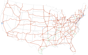 Interstate Highways in the 48 contiguous states | |
| System information | |
| Formed | June 29, 1956[1] |
| Highway names | |
| Interstates | Interstate X (I-X) |
| System links | |
There are gaps in the Interstate Highway system, where the roadway carrying an Interstate shield does not conform to the standards set by the Federal Highway Administration (FHWA), the body that sets the regulations for the Interstate Highway System. For the most part, the Interstate Highway System in the United States is a connected system, with most freeways completed; however, some Interstates still have gaps. These gaps can be due to unconnected segments of the same route or from failure of the road to fully conform to Interstate standards by including such characteristics as at-grade crossings, traffic lights, undivided or narrow freeways, or movable bridges (lift bridges and drawbridges).
True gaps[]
True gaps are where multiple disjoint sections of road have the same Interstate highway number and can reasonably be considered part of "one highway" in theory, based on the directness of connections via other highways, or based on future plans to fill in the gap in the Interstate, or simply based on the shortness of the gap. The sections are either not physically connected at all, or they are connected but the connection is not signed as part of the highway. This list does not include different highways that share the same number, such as the two different I-76s, I-84s, I-86s, I-87s, and I-88s, which despite appearances, were always intended as distinct highways and were never intended as a contiguous route.
Interstate 26[]
In North Carolina, Interstate 26 has a gap from Forks of Ivy to Asheville at exit 4a interchange of Interstate 240. This is because not all of the parts in the gap were built to interstate standards. Right now, Interstate 26 is designated as Future I-26, US 19, and US 23. Construction on building this gap to Interstate Standards will begin in 2021.[2]
Interstate 49[]
Interstate 49 (I-49) currently has four sections: the original alignment from I-10 in Lafayette to I-20 in Shreveport, one from I-220 near Shreveport to Texarkana; the third section from I-40 near Alma, to US 71 south of Bella Vista, replacing most of I-540 and Arkansas Highway 549; and the last section from Pineville, to Kansas City, Missouri. A short, isolated section of I-49 exists in Bella Vista, Arkansas as Arkansas Highway 549. There is also a short section southeast of Fort Smith that is several miles long. These gaps are expected to be eventually closed.
Interstate 69[]
I-69 has several sections: the original alignment travels from Indianapolis, Indiana, to Port Huron, Michigan. A second section exists from near Evansville, Indiana, to Martinsville, Indiana south of Indianapolis; this section is expected to be connected to the original I-69 in Indianapolis by 2024. In stages from 2011 to 2018, sections of the Purchase Parkway, I-24, the Wendell H. Ford Western Kentucky Parkway, and the Pennyrile Parkway from Mayfield, Kentucky, to Henderson, Kentucky, became signed as I-69. Connecting Henderson to Evansville will require bridging the Ohio River, as of 2020 this is not a funded project. On October 2, 2006, a segment of I-69 opened in Tunica and DeSoto counties in Mississippi; this segment has since been continued through Memphis, Tennessee, to an intersection with U.S. Highway 51 on the north side. As of 2020, the State of Tennessee has no plans to complete I-69 between Memphis and Mayfield; nor does the State of Mississippi have plans to extend I-69 further south. Between 2012 and 2015, a portion of U.S. Highway 59 (US 59) between Rosenberg and Cleveland, Texas, extending through Houston, became part of I-69.[3][4][5] In South Texas I-69's route splits into three proposed routes, on which 4 segments are complete: a short segment of I-69E in Corpus Christi and another from Raymondville to the US border in Brownsville; a short segment of I-69C in McAllen; and a very short segment of I-69W in Laredo. The State of Texas has funded continued expansion of I-69 through 2024. As of 2020 the states of Louisiana and Arkansas have not funded any portion of the proposed route (through Pine Bluff and Shreveport) between Mississippi and Texas.
Interstate 74[]
I-74 currently has five sections,[6] the original segment heading northwest from Cincinnati, Ohio, to Davenport, Iowa; one from the Virginia–North Carolina line along I-77 south and east to a point southeast of Mount Airy, North Carolina; one traveling around High Point connecting with I-85 and reaching I-73, where the two are concurrent until Ellerbe; and from west of Laurinburg to south of Lumberton, North Carolina, at I-95. North Carolina is currently working on connecting all its sections of I-74.
Interstate 86[]
The eastern I-86 currently has two sections. One travels for 197 miles (317 km) from I-90 in North East, Pennsylvania (which is a town in the northwestern part of the state) to exit 61 in Waverly, New York. The second section is a 9.9-mile (15.9 km) stretch outside of Binghamton traveling from I-81 in Kirkwood to exit 79 in Windsor. The gap is currently signed as Future 86. I-86 will eventually travel from North East, Pennsylvania, to the New York State Thruway (I-87) near Harriman, New York. All the designated sections and gaps in New York are part of New York State Route 17.
Interstate 99[]
I-99 currently has two sections: one from the Pennsylvania Turnpike to just south of I-80, concurrent with US 220, and one from the Pennsylvania–New York state line north to I-86 in Corning, New York, concurrent with US 15. Much of the intervening route, including the entire US 15 section between I-180 in Williamsport and the New York state line, has been constructed to freeway standards but as of yet is not signed as part of I-99.
The signing of the intervening route as I-99 will be completed when the route is upgraded to Interstate standards, connecting the two segments of I-99.
Freeway gaps[]
Freeway gaps occur where the Interstate is signed as a continuous route, but part, if not all of it, is not up to freeway standards. This includes drawbridges where traffic on the Interstate can be stopped for vessels. This does not include facilities such as tollbooths, toll plazas, agricultural inspection stations, or border stations.
At-grade intersections[]
Major at-grade intersections[]

In urban and heavily-developed areas, Interstates may travel along surface roads or have at-grade intersections with stop signs or traffic lights. The reason for this is usually because the Interstate started construction after the land was heavily-developed and buildings such as residences and businesses and other roads would have to be removed to allow a freeway to pass through. Additionally, more developed land would have to be cleared for space to build interchanges to connect the Interstate and surface streets. This situation is extremely uncommon as Interstates are usually built around cities or through them on pre- or lightly-developed land.
- I-516 downgrades to an expressway as it heads toward its eastern terminus. The expressway features a frontage road right turn and an at-grade intersection with Mildred Street close to the terminus at Montgomery Street and Derenne Avenue (SR 21) in Savannah, Georgia. Mildred Street southbound is closed by concrete barriers.
- I-19 between North West Street and its southern terminus at West Crawford Street at North Sonoita Avenue, in Nogales, Arizona, consists of surface streets with traffic lights. The reason for the signage of this segment is to help direct traffic entering from Mexico to the nearest interstate.
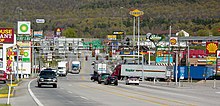
- I-70 uses part of US 30 along a surface road in Breezewood, Pennsylvania. Traffic traveling eastbound on I-70/I-76 must exit and travel a short distance on US 30 in order to continue south on I-70 heading to Hancock, Maryland. (The routing is similar for traffic following I-70 in the opposite direction: traffic traveling north on I-70 must exit and travel a short distance on US 30 in order to continue west on I-70/I-76 or to enter the Pennsylvania Turnpike.) This is one of very few instances of traffic lights on an Interstate. There was formerly a sign of a policeman pointing at drivers leaving the Pennsylvania Turnpike to enter US 30, saying, "You! Slow Down!" Local businesses have lobbied to keep the gap to avoid a perceived potential loss of business (Map).[7]
- I-676 eastbound has a surface street section at the west end of the Ben Franklin Bridge in Philadelphia, Pennsylvania, because of historically-significant areas. Signage and the Federal Highway Administration consider I-676 to use the surface streets; the Pennsylvania Department of Transportation and the New Jersey Department of Transportation consider I-676 to be continuous across the Ben Franklin Bridge, even though the bridge, built in 1926, is not up to Interstate standards (Aerial photo). This does not specifically violate Interstate standards, however, as the two separated segments of I-676 are in different states.
- I-78 travels along a one-way pair of surface streets, 12th Street and 14th Street, in Jersey City, New Jersey, between the end of the New Jersey Turnpike Newark Bay Extension and the Holland Tunnel, which leads into New York City. Between the two aforementioned points are four signalized intersections.[8]
- I-180 in Cheyenne, Wyoming, has no parts built to Interstate standard; in fact the interchange with I-80 is just a simple diamond interchange with two traffic lights on I-180. It is expressway-quality with a few grade separations, however (Map).
- I-81 near Alexandria, New York before the Thousand Islands Bridge across the Saint Lawrence River has intersections with an off-ramp leading from NY-12 and a service road connecting from the bridge toll station to a police department while also intersecting NY-12.
- I-585 near Spartanburg, South Carolina. There are three sets of traffic lights at the northern end where it meets I-85 at a simple diamond interchange; two for the two sets of ramps and an additional light just south of the interchange for a local road. The route is concurrent with US 176, which continues from both ends of I-585.
- I-587 in Kingston, New York has a traffic circle (with yield signs) at its northern terminus with the ramps leading to/from I-87.
Minor at-grade intersections[]
Several Interstates in rural areas of the U.S. have minor at-grade intersections (including median breaks) with farm access roads or authorized vehicle-only driveways used for highway maintenance or connection to nearby utility stations. This is usually due to the lack of an old highway, the need to provide access to property that was accessed via the road prior to its upgrade to an Interstate, and the high cost to construct an interchange for the small amount of traffic that would use such a connection or to build a frontage road parallel to the freeway to the nearest interchange.
- I-11 in Boulder City, Nevada has an at-grade intersection with authorized vehicle-only service road giving access to Buchanan Boulevard and the WAPA Mead substation. An interchange replacing this has been considered.[9]
- I-15 in Wheaton Springs, California (east of Mountain Pass) has several at-grade intersections with dirt roads, including one leading to a house.
- I-15 west of Mesquite, Nevada has an at-grade intersection with Toquop Wash Road, a dirt road. Another access point to Toquop Wash Road passes under the I-15 southbound lanes and connects to the northbound lanes in the median.
- I-15 southbound near Cove Fort, Utah has an at-grade intersection with Cinder Crater Road, a asphalt and gravel road that provides access for trucks to the quarry.
- I-40 in the mountains of western North Carolina has at-grade access to dirt roads. (Example)
- I-40 in western Texas has eight at-grade access points for cattle ranches with median breaks.
- I-80 in Battle Mountain, Nevada intersects with two driveways, including one with a median break, that provide access to a maintenance lot.
- I-80 westbound in western Utah in the Great Salt Lake Desert has two gravel roads that directly connect to the freeway, one accessing the Metaphor: The Tree of Utah artwork and another towards .
- I-94 at Fort Custer west of Battle Creek, Michigan is the only instance of an Interstate freeway in the state of Michigan to have a gated driveway (at 44th Street), which facilitates access of military vehicles.[10]
Other at-grade intersections[]
- The northbound lanes of I-5 in Washington intersect with an at-level crosswalk approximately 100 feet (30 m) south of the border with Canada. This crosswalk allows pedestrians access to a monument that is part of Peace Arch Park.
Undivided and narrow freeways[]


This section addresses two-lane freeways and other narrow or undivided freeway sections of the Interstate, excepting instances of continuing routes using one-lane ramps and merge leads. Narrow gaps between opposing directions with jersey barriers taller than four feet (1.2 m) are excluded from this section; therefore the separation criterion is really either a 4-foot-tall (1.2 m) wall, or a 100-foot-wide (30 m) median, whichever is greater.
- I-40's western 15 miles (24 km) in North Carolina in the has several S-curves, a Jersey barrier with extremely narrow left shoulders and a few at-grade intersections albeit in RIRO style.
- I-55 enters Tennessee from Arkansas on the Memphis and Arkansas Bridge, which itself merits mention as a narrow through truss bridge. Just east of the bridge I-55 transitions from its east–west river crossing to the north–south alignment heading toward Jackson, Mississippi. There is an interchange that forces through I-55 traffic to enter and exit in an old cloverleaf; in 2015 improvements were announced but are stalled. The improvements to the I-55 / Crump Boulevard interchange will be accomplished by constructing new through travel lanes for mainline I-55 traffic, which will eliminate the requirement for interstate traffic to use single-lane, low-speed ramps in order to continue on I-55. A new multi-lane roundabout intersection will be constructed to replace the existing cloverleaf interchange and provide improved access to and from I-55 and existing local roadways.[11]
- Interstate 70 is one-lane only for these following reasons:
- Interstate 70 in Kansas has only one lane for eastbound through traffic for several hundred feet in Kansas City where the highway approaches the Lewis and Clark Viaduct Bridge, which carries the highway over the Kansas River toward Kansas City, Missouri. Interstate 670, just a few blocks south provides an alternate route without this bottleneck.
- Interstate 70 in West Virginia has only one lane for approximately one thousand feet in Wheeling,[12] where the highway enters the Wheeling Tunnel and crosses the Ohio River on the Fort Henry Bridge. Nearby I-470 provides relief from this situation.
- The Mackinac Bridge, which carries I-75 over the Straits of Mackinac between St. Ignace and Mackinaw City, Michigan, has no wide median or hard shoulders due to space constraints. Nor does it have a Jersey barrier; instead, it has either a 4-inch-tall (10 cm) yellow divider between the opposing directions (where the inner lanes are a metal grate) or a flat double-yellow line (where the inner lanes are paved). The speed limit is also reduced to 45 mph (70 km/h) for cars and 20 mph (30 km/h) for trucks. The highway returns to Interstate standard for about 50 miles until it reaches the Sault Ste. Marie International Bridge, which carries undivided lanes to the Canada–US border in the middle of the bridge, where I-75 terminates.
- The Thousand Islands Bridge, which carries I-81 over part of the Saint Lawrence River, is an undivided two-lane road.
- I-93 is a two-lane divided parkway, or a "super two", through Franconia Notch in New Hampshire. A four-lane Interstate Highway was once proposed here, but the concept was abandoned because of environmental concerns, in part because of vibrations that could harm the Old Man of the Mountain rock formation (which collapsed in 2003 regardless). This section of highway was for many years marked as US 3 and "To I-93", but these have now been replaced with regular I-93 signs. The Federal Highway Act of 1973 exempts this 7.6-mile (12.2 km) stretch from the Interstate Highway standards that apply elsewhere, and this highway is considered to be I-93 for all practical purposes.[13] This section of I-93 in New Hampshire is now the only remaining multi-mile section of two-lane freeway on an Interstate Highway in the United States.[citation needed] In addition, parking along portions of I-93 through Franconia Notch was permitted until early 2019 when barriers and signage were posted due to safety concerns.[14]
- Some stretches of Interstate highway use a barrier transfer machine on some bridges to convert inner lanes from one direction to the other, where it would be too costly to upgrade/rebuild to a higher-capacity bridge. In any case the traffic distribution is strongly asymmetric depending on the hour of the day. This kind of bridge typically contains undivided lanes without the flexible Jersey barrier that is manipulated by machines.
Movable bridges[]

By Interstate standard, all bridges on the Interstate system must be fixed as to not interrupt the flow of traffic. Several bridges on the system, however, are movable:
- I-5 crosses the Columbia River from Portland, Oregon, to Vancouver, Washington, on the Interstate Bridge, a vertical-lift bridge. The Columbia River Crossing project sought to replace this bridge[15] until being abandoned in 2013.[16]
- I-110 has a drawbridge across the Back Bay of Biloxi in Biloxi, Mississippi.
- I-64—the Hampton Roads Beltway—crosses the South Branch Elizabeth River in Chesapeake, Virginia, on the High Rise Bridge, which is a drawbridge, expected to be replaced by a larger fixed bridge in 2021.[17][18]
- I-264 has a drawbridge, the Berkley Bridge, crossing the Elizabeth River in Norfolk, Virginia.
- I-278 has a drawbridge across the Bronx River in New York City.
- I-280 has a drawbridge, the Stickel Memorial Bridge, crossing over the Passaic River between Newark and Harrison, New Jersey.
- I-95/I-495 pass together as the Capital Beltway over the Potomac River on the Woodrow Wilson Bridge, a double-leaf bascule span. Even though the original bridge was replaced in the 2000s, the new bridge also has a draw span, albeit with more vertical clearance resulting in fewer openings than the old bridge—about 65 per year, an average of about one every six days.
- I-695 has a drawbridge over Curtis Creek, south of Baltimore and just west of the Francis Scott Key Bridge. This section of the Baltimore Beltway is not part of the Interstate Highway System, however, and is officially Maryland Route 695 despite the Interstate signage on the highway.[19][20]
Freeway-to-freeway crosspaths without direct connection[]
- I-422 (currently under construction) will have no direct freeway connection to its parent I-22, though the two routes will cross near Adamsville, Alabama.
- I-271 in Ohio lacks a direct interchange with the I-80 section of the Ohio Turnpike; traffic interchanges between the two via I-77 and Ohio State Route 8, which both pass nearby.
- I-475 has no direct interchange with I-80/I-90 on the Ohio Turnpike.
- I-476 does not have a direct interchange with I-78 in Lehigh County, Pennsylvania, though there is an indirect connection via US 22 and PA 309. It also does not connect directly with I-80, where the connection is made through a traffic light at an at-grade road.
- I-81 connects to I-76 via US 11 at-grade roads in Carlisle, Pennsylvania.
- The Massachusetts Turnpike (I-90) passes over I-391 without interchange in Chicopee, Massachusetts. The overpass is about one mile (1.6 km) north of the I-391 southern terminus at I-91, and approximately 1.4 miles (2.3 km) from the Mass Pike interchange with I-91 and US 5.
- I-95 (NJ Turnpike Pearl Harbor Memorial Extension) passes under I-295 without interchange in Columbus, New Jersey
- I-195 passes over I-895 without interchange near Halethorpe, Maryland.
- I-295 passes over I-276 without direct interchange in Bristol Township, Pennsylvania.
- I-99 has connection gaps with both I-70/I-76 and I-80 in central Pennsylvania, both through at grade roads near Bedford and Bellefonte, Pennsylvania. The latter is expected to be filled as part of I-99's aforementioned northern extension.
Connection gaps[]
Auxiliary Interstates (also known as three-digit Interstates) are intended to connect to their parent either directly or via a same-parented Interstate (like I-280 in California being connected to I-80 via I-680). Often, these connection gaps occur to eliminate concurrencies between other three-digit routes. Freeway gaps (signed or unsigned) that officially connect auxiliary routes to the parent are excluded.
Current day examples[]
- I-210 in California does not currently connect directly to I-10 or any of its spurs according to freeway signage. It was signed all the way to I-10 until 1998, when California State Route 57 replaced the portion of I-210 through Covina and San Dimas to provide a proper connection to current State Route 210. The former portion of I-210 now known as SR 57 still remains on the Interstate Highway System federally defined as Interstate 210[21] maintaining its connection to I-10, but it is not signed as per Caltrans tradition to sign state highways by their state definition over their federal definition. State Route 210, built as an extension to replace Route 30, connects to I-10 further east in Redlands, and California is petitioning to have that portion signed as I-210 as well. When that happens, this gap will close.
- I-238 does not have a parent. It was previously a part of California State Route 238 that was built to Interstate standards, and it was added to the Interstate system using the same number it had as a state highway. The exit numbers continue the mileage from the state highway instead of starting over from 1.[22]
- None of the spurs of I-78 in New York City (I-278, I-478, I-678, I-878) connect to the parent road I-78, nor is there any surface-street with a state route designation with the same number that continues with a solid connection. I-78 was planned to extend southeast through New York City via the Lower Manhattan Expressway, Williamsburg Bridge and Bushwick Expressway, then east along what is now I-878 and north along what is now I-295. I-78 would have then split into two branches (the current I-295 and I-695), which would have both terminated at I-95.[23][24] I-478 comes the closest, and would have intersected I-78 as part of the Westway project;[25]: 10 this project was later canceled.[26] I-278, the only I-78 spur to leave New York City, was planned to extend northwest to I-78 at Route 24.[27] Since all the spurs are interconnected, only one of them needs to be eventually connected to its parent route for all of them to conform to numbering standards.
- Numerous three-digit Interstate routes are unsigned on some portions, leading some to think there are connection gaps. However, these so-called connection gaps do not have internal unsigned concurrencies on other Interstate highway segments between the "parent route" and signed terminus.
See also[]
 U.S. Roads portal
References[]
- ^ Weingroff, Richard F. (Summer 1996). "Federal-Aid Highway Act of 1956, Creating the Interstate System". Public Roads. Washington, DC: Federal Highway Administration. 60 (1). Retrieved March 16, 2012.
- ^ "NCDOT: Asheville I-26 Connector". NCDOT. Retrieved April 15, 2021.
- ^ Special Committee on U.S. Route Numbering (May 19, 2012). "Report to SCOH" (PDF) (Report). Washington, DC: American Association of State Highway and Transportation Officials. Archived (PDF) from the original on June 3, 2019.
- ^ "Alliance for I-69 Texas: More Houston Areas Freeway Added to Interstate 69". Alliance for I-69 Texas. February 28, 2013.
- ^ "Texas Transportation Commission Minute Order" (PDF). Texas Transportation Commission. March 26, 2015.
- ^ Malme, Bob. "I-74 North Carolina Progress Page". Archived from the original on July 25, 2010. Retrieved August 28, 2009.[self-published source]
- ^ Roig-Franzia, Manuel (November 22, 2001). "The Town That Stops Traffic: Travelers Encounter Way Station as Way of Life in Breezewood". The Washington Post. p. B1.
- ^ Google (August 28, 2009). "Intersection of 14th St (ostensibly 78 West) and Erie St" (Map). Google Maps. Google. Retrieved August 28, 2009.
- ^ "Buchanan or bust. Proposal seems to lack supporters". . May 24, 2017. Retrieved December 16, 2020.
- ^ Michigan Department of Transportation (n.d.). "Road & Highway Facts". Michigan Department of Transportation. Retrieved October 28, 2014.
- ^ "Interstate 55 Crump Boulevard Interchange". www.tn.gov. Retrieved June 7, 2021.
- ^ "North America to 870 I-70". North America to 870 I-70. Retrieved April 15, 2021.
- ^ Weingroff, Richard (April 7, 2011). "Interstate System Conditions and Performance". Highway History. Federal Highway Administration. Retrieved August 20, 2012.
- ^ KOZIOL, JOHN. "Hikers warned not to park along Franconia Notch Parkway in multi-agency crackdown". UnionLeader.com. Retrieved April 15, 2021.
- ^ Project staff. "Home". Columbia River Crossing. Oregon Department of Transportation and Washington State Department of Transportation. Retrieved August 28, 2009.
- ^ Read, Richard (July 5, 2013). "Bridge Funds to Nowhere: Some of the $175 million in work for the now-defunct Columbia River Crossing might be useful someday, but much of it is just gone". The Oregonian. Portland. p. A1. Retrieved July 5, 2013.
- ^ "Groundbreaking on I-64 widening, High Rise Bridge project". January 12, 2018. Retrieved December 31, 2019.
- ^ "I-64 High-Rise Bridge project could raise economic opportunities". December 4, 2018.
- ^ Highway Information Services Division (December 31, 2007). Highway Location Reference. Maryland State Highway Administration. Retrieved April 15, 2009.
- Anne Arundel County (PDF).
- ^ Highway Services Division (2010). "Movable Bridges on State Maintained Highways" (PDF). Maryland State Highway Administration. Retrieved October 18, 2010.
- ^ Federal Highway Administration. National Highway System: Los Angeles, CA (PDF) (Map). Scale not given. Federal Highway Administration. Retrieved February 5, 2012.
- ^ Casey. "Indigestion 238". Casey's Roads and Highways Page. Retrieved January 26, 2013.[unreliable source]
- ^ New York City (Map). Rand McNally and Company. 1960. Retrieved April 15, 2010.
- Note that I-95 is shown on the Hutchinson River Parkway north of the Bruckner Interchange, but the 1955 "Yellow Book" map shows the I-78 route on the Bruckner Expressway.
- ^ A Report on Airport Requirements and Sites in the Metropolitan New Jersey–New York Region. Port of New York Authority. 1961. p. 73. OCLC 2551801.
- ^ West Side Hwy Project, New York: Environmental Impact Statement. West Side Hwy Project, New York: Environmental Impact Statement. New York State Department of Transportation; Federal Highway Administration, United States Department of Transportation. 1977. Retrieved March 19, 2018.
- ^ Roberts, Sam (October 7, 1985). "THE LEGACY OF WESTWAY: LESSONS FROM ITS DEMISE". The New York Times. Retrieved March 22, 2018.
- ^ * Union County Sheet 1 (Map). New Jersey Department of Transportation. 1967. Retrieved February 13, 2010.
- Union County Sheet 2 (Map). New Jersey Department of Transportation. 1967. Retrieved February 13, 2010.
External links[]
- Interstate Highway System
- Lists of roads in the United States
- Movable bridges on the Interstate Highway System