Bella Vista, Arkansas
Bella Vista, Arkansas | |
|---|---|
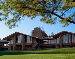
 Clockwise, from top: Mildred B. Cooper Memorial Chapel, Lake Ann, Bella Vista golf, and a waterfall along Tanyard Creek | |
 Flag | |
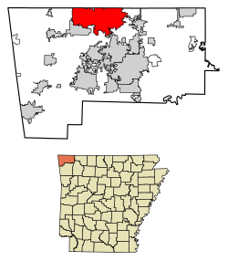 Location of Bella Vista in Benton County, Arkansas | |
 Bella Vista Location in Arkansas | |
| Coordinates: 36°28′8″N 94°16′7″W / 36.46889°N 94.26861°WCoordinates: 36°28′8″N 94°16′7″W / 36.46889°N 94.26861°W | |
| Country | United States |
| State | Arkansas |
| County | Benton |
| Government | |
| • Mayor | Peter Christie |
| Area | |
| • Total | 46.88 sq mi (121.41 km2) |
| • Land | 45.31 sq mi (117.35 km2) |
| • Water | 1.57 sq mi (4.07 km2) |
| Elevation | 1,150 ft (350 m) |
| Population (2010) | |
| • Total | 26,461 |
| • Estimate (2019)[2] | 28,872 |
| • Density | 637.25/sq mi (246.04/km2) |
| Time zone | UTC−6 (Central (CST)) |
| • Summer (DST) | UTC−5 (CDT) |
| ZIP codes | 72714, 72715 |
| Area code(s) | 479 |
| FIPS code | 05-04840 |
| GNIS feature ID | 0076292 |
| Website | www |


Bella Vista is a city in Benton County, Arkansas, United States. First established in 1917 [3] as a summer resort destination, Bella Vista has evolved and redesigned itself over the succeeding years. Bella Vista became a retirement community in 1965, and, after much contention and a 2006 vote of its property owners, became an incorporated city. Following its official incorporation on January 1, 2007, the new city government took over the police department, fire department, streets, trash removal and other city functions, while the Property Owners Association (POA) retained control of the many amenities available to homeowners and their guests. Amenities include numerous parks, clubhouses with workout areas, swimming pools, six 18-hole golf courses, one nine-hole golf course, seven lakes with fishing and boat docks (three ski lakes), a marina, swimming beach, putt putt golf courses and tennis courts, dog park, softball field, and extensive hiking and biking trails.
The city of Bella Vista is located on the Springfield Plateau of the Ozark Mountains. Oak/hickory forests, along with valleys, creeks, and steep rises, characterize the city's topography. Bella Vista is located north of Bentonville and Rogers and is the northernmost Arkansas city in the Standard Metropolitan Statistical Area (which includes McDonald County, Missouri). The city has been experiencing a population and building boom in recent years, as indicated by a 60% growth in population between the 2000 and 2010 censuses.
Geography[]
Bella Vista is located in northern Benton County. Its northern border is the Missouri state line. According to the United States Census Bureau, the city has a total area of 45.9 square miles (118.9 km2), of which 44.2 square miles (114.6 km2) is land and 1.6 square miles (4.2 km2) is water,[4] consisting mainly of the several lakes within the city.
Demographics[]
| Historical population | |||
|---|---|---|---|
| Census | Pop. | %± | |
| 1980 | 2,589 | — | |
| 1990 | 9,083 | 250.8% | |
| 2000 | 16,582 | 82.6% | |
| 2010 | 26,461 | 59.6% | |
| 2019 (est.) | 28,872 | [2] | 9.1% |
| [5] | |||
As of the census[6] of 2000, there were 16,582 people, 7,818 households, and 6,004 families residing in the community, which at the time was recorded as a census-designated place (CDP). The population density was 252.8 inhabitants per square mile (97.6/km2). There were 8,854 housing units at an average density of 135.0 per square mile (52.1/km2). The racial makeup of the CDP was 97.87% White, 0.18% Black or African American, 0.69% Native American, 0.27% Asian, 0.01% Pacific Islander, 0.20% from other races, and 0.78% from two or more races. Hispanic or Latino of any race were 1.01% of the population.
There were 7,818 households, out of which 13.5% had children under the age of 18 living with them, 72.4% were married couples living together, 3.2% had a female householder with no husband present, and 23.2% were non-families. 20.5% of all households were made up of individuals, and 13.3% had someone living alone who was 65 years of age or older. The average household size was 2.10 and the average family size was 2.38.
In the CDP, the population was spread out, with 12.3% under the age of 18, 3.0% from 18 to 24, 16.4% from 25 to 44, 26.3% from 45 to 64, and 41.9% who were 65 years of age or older. The median age was 61 years. For every 100 females, there were 92.5 males. For every 100 females age 18 and over, there were 90.9 males.
The median income for a household in the CDP was $44,090, and the median income for a family was $48,233. Males had a median income of $34,547 versus $24,690 for females. The per capita income for the CDP was $25,406. About 1.5% of families and 2.5% of the population were below the poverty line, including 3.7% of those under the age of 18 and 1.0% of those 65 and older.
Government[]
Bella Vista's Declarations and Protective Covenants[7] is the "rule book" that governs the POA. The Property Owners Association must follow this "rule book" composed of various articles. There are Class A and Class B members of the POA. Class B refers to Cooper Communities, the land developer, who gets 10 votes per lot owned and Class A refers to lot private lot purchasers who receive one vote per lot owned. Cooper Communities now owns too few lots to sway the vote. Both Class A and class B members must approve a vote before it is binding.
The POA is governed by a nine-member Board of Directors who serve three-year terms. They set the direction and long-term objectives for the POA guided by Bella Vista's declarations and protective covenants. The day-to-day activity of the POA is directed by its general manager, with division heads and site managers responsible for the various departments and facilities.
The residents voted in 2006 to incorporate as an official city effective January 1, 2007. The POA still remains intact to service the recreational amenities and provide water, but the City of Bella Vista now has responsibility for police, fire, streets, library, community development, and other services.
Parks and recreation[]
Lakes[]

Bella Vista has seven lakes. These lakes are not "public" in that only members of the community or their guests are permitted to use them. Lake Ann, Lake Windsor, and Lake Loch Lomond are the largest all-sports lakes in the town. Lake Avalon, Lake Norwood, and Lake Rayburn are primarily fishing lakes with "no-wake" restrictions. Current POA boat permits are required, as are Arkansas fishing licenses, when fishing Bella Vista lakes. No personal water crafts (AKA: Jet Skis) are allowed on any of the Bella Vista lakes, however, only 20 miles east of Bella Vista is Beaver Lake, a 31,700 acre US Army Corps of Engineers Lake, and Jet Skis are welcome there.
- Lake Ann is a water sport lake with 112.5 acres (0.455 km2) of surface area. Because it is 53.5 feet (16.3 m) deep with no power limit, water skiing is allowed on Lake Ann.
- Lake Windsor is the second largest of the lakes, covering 220 acres (0.89 km2) with a maximum depth of 79.5 feet (24.2 m). Lake Windsor is also an unlimited power lake, and water skiing is allowed.
- Loch Lomond is the largest of all the lakes in the city. It is 80 feet (24 m) deep and covers 477 acres (1.93 km2). There is no power limit, skiing is allowed, and boat rental is offered.
- Lake Avalon is a limited-power lake that features an enclosed, heated fishing dock located off Tamworth Circle. This lake covers 67 acres (270,000 m2) and is 50 feet (15 m) deep.
- Lake Brittany is 77 feet (23 m) deep, has a 35-acre (140,000 m2) surface area and is a limited-power lake.
- Lake Norwood, located just north of Bella Vista's Town Center, has 34.5 acres (140,000 m2) of surface area and is 75 feet (23 m) deep. The Lake Norwood launching ramp is located north of Harp's Food Store in Town Center. This is a limited-power lake.
- Lake Rayburn is 60 feet (18 m) deep and has a 47-acre (190,000 m2) surface area. This lake has limited-power regulations. It also features a designated swimming area and a launching ramp that is accessible from Lakeside Drive.
Trails[]

Lake Bella Vista, formerly part of Bella Vista, and the 1.8 mile walking/biking trail that goes around the lake is now part of the City of Bentonville Parks system. In the center of Bella Vista is the Tanyard Creek Nature Trail[8] below the Lake Windsor dam. It has a footbridge and some waterfalls except during dry times. In October 2016 the City of Bella Vista, with the cooperation of the Property Owners Association, opened 40 mi (64 km) of hiking and mountain bike trails entitled 'The Back 40' which is located on the east side of the city. The trail Master Plan developed in 2015 shows 150 mi (240 km) over the next 10+ years. The next 40+ miles to be located within the central part of the city are in the planning stage.
Education[]
There are two school districts serving the city. On the east side is the Bentonville School District,[9] and on the west side is Gravette School District.[10] Also serving the city is a private preschool, Bella Vista Montessori Academy.[11] Cooper Elementary, part of the Bentonville District, is a K-4. The Bentonville School district is planning two new schools for Bella Vista students.
Northwest Arkansas Community College is also part of the community, with its main branch in Bentonville near I-49 Exit 86.
Infrastructure[]
Electricity[]
Carroll Electric Cooperative provides electricity for Bella Vista residents.
Public safety[]

The Bella Vista Fire Department is a career fire department with four fully staffed fire stations. There are three shifts with 16 career firefighters on each shift. The fire department also provides Advanced Life Support paramedic service to the city with six ambulances. In 2010, the department took control over the Bella Vista Ambulance Services.
Transportation[]
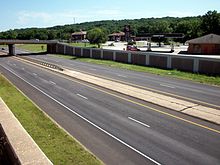
Infrastructure issues currently exist in Bella Vista, where traffic levels are quickly increasing. Interstate 49 runs from Ft. Smith to the south end of Bella Vista, picking up again at Pineville, Missouri, with U.S. 71 going through the center of Bella Vista. A two-lane bypass around the west side of Bella Vista has been completed from Bentonville to just short of the Missouri state line. Eventually that bypass will become four lanes and become part of I-49, connecting to the present I-49 in Pineville, Missouri. Many drivers in both Arkansas and Missouri, especially ones with semi trucks, are desperate to see the highway became fully connected and flowing because of the current traffic congestion. The construction of the Bella Vista Bypass began on June 8, 2011.[12]
Solid waste[]
The POA provides water service to Bella Vista residents. The City of Bella Vista contracts with Republic Services for trash collection. There also are two semi-annual pick ups of large items.
Stump Dump Fire of 2018[]
A dump site had begun an underground fire in August of 2018. In December of 2018, health officials declared the air within a half-mile radius around the property was at unhealthy levels on one occasion. An emergency declaration was made by Gov. Asa Hutchinson. [13]The Bella Vista POA took over this project in early May 2019 and had the fire extinguished in less than 30 days. [14]
Water and wastewater[]
Village Waste Water provides sewer service to portions of Bella Vista.
Notable people[]
- Donna Hutchinson, member of the Arkansas House of Representatives from 2007 to 2013
- Jim Sheets, member of the Arkansas House from 1967 to 1968 in the Winthrop Rockefeller administration; retired resident of Bella Vista
- Garth Smith - award winning pianist/composer/musician noted for his contributions to LDS Gospel Music.
See also[]
References[]
- ^ "2019 U.S. Gazetteer Files". United States Census Bureau. Retrieved June 30, 2020.
- ^ Jump up to: a b "Population and Housing Unit Estimates". Retrieved May 21, 2020.
- ^ bellavistamuseum.org
- ^ "Geographic Identifiers: 2010 Demographic Profile Data (G001): Bella Vista town, Arkansas". U.S. Census Bureau, American Factfinder. Archived from the original on February 12, 2020. Retrieved September 24, 2013.
- ^ Spurgeon, John (March 19, 2012). "Bella Vista (Benton County)". Encyclopedia of Arkansas History and Culture. Butler Center for Arkansas Studies at the Central Arkansas Library System. Retrieved October 24, 2013.
- ^ "U.S. Census website". United States Census Bureau. Retrieved 2008-01-31.
- ^ Bella Vista Village Property Owner's Association Governing Documents Archived June 22, 2011, at the Wayback Machine
- ^ "Hike the Tanyard Creek Nature Trail". www.theoutbound.com. Retrieved 2021-06-17.
- ^ Bentonville Public Schools
- ^ "Welcome to Gravette Public Schools". Archived from the original on 2006-01-15. Retrieved 2006-01-14.
- ^ Bella Vista Montessori Academy - Home Archived February 28, 2008, at the Wayback Machine
- ^ "Archived copy". Archived from the original on 2013-12-21. Retrieved 2013-12-22.CS1 maint: archived copy as title (link)
- ^ "SPECIAL REPORT: The science behind the Bella Vista stump dump". 22 July 2019.
- ^ "Bella Vista POA Talks About Phase Two After Former Stump Dump Fire is Out".
External links[]
| hide Municipalities and communities of Benton County, Arkansas, United States | ||
|---|---|---|
| Cities |  | |
| Towns | ||
| Townships | ||
| CDPs | ||
| Other communities | ||
| Ghost towns | ||
| Footnotes | ‡This populated place also has portions in an adjacent county or counties | |
| ||
| Authority control |
|
|---|
- Bella Vista, Arkansas
- Cities in Benton County, Arkansas
- Northwest Arkansas
- Former census-designated places in Arkansas
- Cities in Arkansas
- Populated places established in 2006
- 1917 establishments in Arkansas