Adamsville, Alabama
Adamsville, Alabama | |
|---|---|
 Porter Mine Company Housing for Black Miner in Adamsville, 1946 | |
| Nickname(s): Adam | |
 Location of Adamsville in Jefferson County, Alabama. | |
| Coordinates: 33°35′25″N 86°56′57″W / 33.59028°N 86.94917°W | |
| Country | United States |
| State | Alabama |
| County | Jefferson |
| Government | |
| • Mayor | Pam Palmer |
| Area | |
| • Total | 26.42 sq mi (68.44 km2) |
| • Land | 26.21 sq mi (67.90 km2) |
| • Water | 0.21 sq mi (0.54 km2) 0.05% |
| Elevation | 577 ft (176 m) |
| Population (2020) | |
| • Total | 4,366 |
| • Density | 166.55/sq mi (64.30/km2) |
| Time zone | UTC-6 (CST) |
| • Summer (DST) | UTC-5 (CDT) |
| ZIP code | 35005 |
| Area codes | 205 & 659 |
| FIPS code | 01-00460 |
| GNIS feature ID | 112930 |
| Website | www.cityofadamsville.org |

Adamsville is a city in western Jefferson County, Alabama. It is north from the Birmingham suburb of Pleasant Grove. It initially incorporated in 1901 (although the 1910 U.S. Census stated 1900), but disincorporated in 1915.[2] It later reincorporated in 1953.[3] According to the 2010 census, this town had a population of 4,522, down from its peak population of 4,965 in 2000.
Geography[]
Adamsville is located at 33°35′25″N 86°56′57″W / 33.59028°N 86.94917°W (33.590411, -86.949166).[4]
According to the United States Census Bureau, the town has a total area of 19.6 square miles (51 km2), of which 19.6 square miles (51 km2) is land and 0.05% is water.
Demographics[]
Adamsville[]
| Historical population | |||
|---|---|---|---|
| Census | Pop. | %± | |
| 1910 | 649 | — | |
| 1950 | 1,531 | — | |
| 1960 | 2,095 | 36.8% | |
| 1970 | 2,412 | 15.1% | |
| 1980 | 2,498 | 3.6% | |
| 1990 | 4,161 | 66.6% | |
| 2000 | 4,965 | 19.3% | |
| 2010 | 4,522 | −8.9% | |
| 2020 | 4,366 | −3.4% | |
| U.S. Decennial Census[5] | |||
Adamsville first appeared on the 1910 U.S. Census as an incorporated town.[6] It disincorporated in 1915 and did not appear on the census again until 1950, when it reported as an unincorporated village.[7] It reincorporated in 1953 as a town[8] and has appeared on every successive census to date. In the 1960s, it upgraded from town to city status.[9]
2000 Census[]
At the 2000 census, there were 4,965 people, 1,930 households and 1,464 families living in the town. The population density was 253.2 per square mile (97.8/km2). There were 2,042 housing units at an average density of 104.2 per square mile (40.2/km2). The racial makeup of the town was 75.79% White, 22.82% Black or African American, 0.40% Native American, 0.14% Asian, 0.02% Pacific Islander, 0.16% from other races, and 0.66% from two or more races. 0.52% of the population were Hispanic or Latino of any race.
There were 1,930 households, of which 32.1% had children under the age of 18 living with them, 59.1% were married couples living together, 13.5% had a female householder with no husband present, and 24.1% were non-families. 21.7% of all households were made up of individuals, and 9.1% had someone living alone who was 65 years of age or older. The average household size was 2.56 and the average family size was 2.97.
23.1% of the population were under the age of 18, 8.0% from 18 to 24, 27.6% from 25 to 44, 25.1% from 45 to 64, and 16.1% who were 65 years of age or older. The median age was 39 years. For every 100 females, there were 90.9 males. For every 100 females age 18 and over, there were 88.2 males.
The median household income was $39,563 and the median family income was $46,270. Males had a median income of $36,188 compared with $22,292 for females. The per capita income for the town was $18,496. About 5.1% of families and 6.4% of the population were below the poverty line, including 10.3% of those under age 18 and 9.1% of those age 65 or over.
2010 census[]
At the 2010 census, there were 4,522 people, 1,752 households and 1,253 families living in the town. The population density was 230.7 per square mile (89.0/km2). There were 1,990 housing units at an average density of 101.5 per square mile (39.2/km2). The racial makeup of the town was 52.3% White, 44.9% Black or African American, 0.5% Native American, 0.3% Asian, 0.0% Pacific Islander, 1.1% from other races, and 0.8% from two or more races. 2.3% of the population were Hispanic or Latino of any race.
There were 1,752 households, of which 27.7% had children under the age of 18 living with them, 47.6% were married couples living together, 18.0% had a female householder with no husband present, and 28.5% were non-families. 24.7% of all households were made up of individuals, and 10.4% had someone living alone who was 65 years of age or older. The average household size was 2.57 and the average family size was 3.08.
23.6% of the population were under the age of 18, 8.1% from 18 to 24, 25.1% from 25 to 44, 27.2% from 45 to 64, and 15.9% who were 65 years of age or older. The median age was 39.9 years. For every 100 females, there were 88.6 males. For every 100 females age 18 and over, there were 92.4 males.
The median household income was $52,167 and the median family income was $56,551. Males had a median income of $41,176 compared with $31,349 for females. The per capita income for the town was $23,461. About 7.9% of families and 11.0% of the population were below the poverty line, including 21.1% of those under age 18 and 10.1% of those age 65 or over.
2020 census[]
| Race | Num. | Perc. |
|---|---|---|
| White (non-Hispanic) | 1,724 | 39.49% |
| Black or African American (non-Hispanic) | 2,300 | 52.68% |
| Native American | 18 | 0.41% |
| Asian | 10 | 0.23% |
| Pacific Islander | 3 | 0.07% |
| Other/Mixed | 129 | 2.95% |
| Hispanic or Latino | 182 | 4.17% |
As of the 2020 United States census, there were 4,366 people, 1,471 households, and 1,032 families residing in the city.
Adamsville Census Division (1960-70)[]
| Historical population | |||
|---|---|---|---|
| Census | Pop. | %± | |
| 1960 | 16,020 | — | |
| 1970 | 18,941 | 18.2% | |
| U.S. Decennial Census[11] | |||
The Jefferson County Census Division of Adamsville was created in 1960 as part of a general reorganization of counties, which included the town of Adamsville and the surrounding areas.[12] From 1910-1960, Adamsville had been in the unnamed 39th precinct of Jefferson County.[13] In 1980, Adamsville became a part of the Graysville-Adamsville Census Division.[14]
Notable people[]
- Henry E. Erwin, Medal of Honor recipient during World War II
- Brandon Johnson, former NFL linebacker and 2001 Minor High School graduate[15]
- Jim King, head football coach of the University of West Alabama from 1973 to 1976
- Bryan Thomas, former linebacker and defensive end for the New York Jets and 1996 graduate of Minor High School[16]
- Chris Williams, professional basketball player and 1998 graduate of Minor High School[17]
- Nick Williams, NFL defensive end and 2008 graduate of Minor High School
Photo Gallery[]

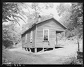
Home of Black miners in company housing project, 1946

Children on porch of home of Black miners in company housing project, 1946
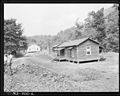
Homes for Black miners in company housing project, 1946

Home of Alvis New, Miner, living in company housing project, 1946

Homes of Black miners in company housing project, 1946
Home of Eddie Cain, Miner, living in company housing project, 1946

Mrs. Aron Conway and baby swinging on porch of their home, 1946

Bedroom of Mining Cabin of Mr. Eddie Cain, 1946

Bedroom of Mining Cabin of Mr. Alvis New, 1946

Mrs. Butler Phillips, wife of miner, dressing a chicken on back porch of her home, 1946

Mr. Eddie Cain, Miner, Looking over his bills in his home, 1946

Mining Cabin Home of Mr. Butler Phillips, 1946

Backyard of home of Butler Phillips with family tending to farm animals, 1946

Detail of Cain family kitchen in mining cabin, 1946


References[]
Notes[]
References[]
- ^ "2020 U.S. Gazetteer Files". United States Census Bureau. Retrieved October 29, 2021.
- ^ http://www.lsa.state.al.us/PDF/LRS/Local_Laws/LL_JEFFERSON.pdf Archived 2019-10-01 at the Wayback Machine. Adamsville charter adopted 1900, dissolved 1915
- ^ "Adamsville - Encyclopedia of Alabama". Encyclopedia of Alabama.
- ^ "US Gazetteer files: 2010, 2000, and 1990". United States Census Bureau. 2011-02-12. Retrieved 2011-04-23.
- ^ United States Census Bureau. "Census of Population and Housing". Archived from the original on April 26, 2015. Retrieved August 8, 2013.
- ^ http://www2.census.gov/prod2/decennial/documents/41033935v1-8ch1.pdf
- ^ http://www2.census.gov/prod2/decennial/documents/23761117v1ch04.pdf
- ^ http://www2.census.gov/prod2/decennial/documents/37721510v1p2ch2.pdf
- ^ https://www2.census.gov/prod2/decennial/documents/1970a_al-01.pdf. P. 2-24 (30), footnote 36
- ^ "Explore Census Data". data.census.gov. Retrieved 2021-12-11.
- ^ "U.S. Decennial Census". Census.gov. Retrieved June 6, 2013.
- ^ http://www2.census.gov/prod2/decennial/documents/37721510v1p2ch2.pdf, 1960 AL Census
- ^ http://www2.census.gov/prod2/decennial/documents/23761117v1ch04.pdf, 1950 AL Census
- ^ http://www2.census.gov/prod2/decennial/documents/1980a_alABC-01.pdf, 1980 AL Census
- ^ Beaudry, Paul. "Former Minor star Brandon Johnson set for camp with NFL's Steelers". al.com. Alabama Media Group. Retrieved 29 April 2015.
- ^ "Bryan Thomas Bio". UAB Athletics. University of Alabama Birmingham. Retrieved 29 April 2015.
- ^ "Minor High Tigers". Alabama High School Basketball History. AHSFHS.org. Retrieved 29 April 2015.
Coordinates: 33°35′25″N 86°56′57″W / 33.590411°N 86.949166°W
Municipalities and communities of Jefferson County, Alabama, United States | ||
|---|---|---|
| Cities |  | |
| Towns | ||
| CDPs | ||
| Other unincorporated communities | ||
| Former towns | ||
| Footnotes | ‡This populated place also has portions in an adjacent county or counties | |
| ||
- Cities in Alabama
- Cities in Jefferson County, Alabama
- Birmingham metropolitan area, Alabama