Qalat, Shiraz
Qalat
قلات | |
|---|---|
village | |
 | |
 Qalat | |
| Coordinates: 29°49′14″N 52°19′48″E / 29.82056°N 52.33000°ECoordinates: 29°49′14″N 52°19′48″E / 29.82056°N 52.33000°E | |
| Country | |
| Province | Fars |
| County | Shiraz |
| Bakhsh | Central |
| Rural District | Derak |
| Population (2006) | |
| • Total | 2,613 |
| Time zone | UTC+3:30 (IRST) |
| • Summer (DST) | UTC+4:30 (IRDT) |

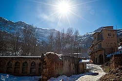
Qalat (Persian: قلات, also Romanized as Qalāt; also known as Kalāt)[1] is a village in Derak Rural District, in the Central District of Shiraz County, Fars Province, Iran. At the 2006 census, its population was 2,613, in 697 families.[2]
There is a church called the Glory of Christ in the village. This building has survived from the Qajar period and is surrounded by charming gardens.[3]
References[]
- ^ Qalat can be found at GEOnet Names Server, at this link, by opening the Advanced Search box, entering "-3078829" in the "Unique Feature Id" form, and clicking on "Search Database".
- ^ "Census of the Islamic Republic of Iran, 1385 (2006)" (Excel). Statistical Center of Iran. Archived from the original on 2011-11-11.
- ^ Iranian Monuments: Historical Churches in Iran Archived June 5, 2011, at the Wayback Machine
This Shiraz County location article is a stub. You can help Wikipedia by . |
Categories:
- Populated places in Shiraz County
- Shiraz County geography stubs