Quay Street, Auckland
 | |||
| Length | 1.8 km (1.1 mi) | ||
|---|---|---|---|
| Location | Auckland CBD, New Zealand | ||
| Postal code | 1010 | ||
| West end | Hobson Street, Viaduct Harbour | ||
| East end | Tamaki Drive, The Strand | ||
Quay Street is the northernmost street in the Auckland CBD. The Auckland Ferry Terminal, which has ferries running to Devonport, Waiheke Island, and other places in Waitematā Harbour; the Hilton Auckland hotel; and Ports of Auckland are on the north side of the street. The Britomart Transport Centre, Queen Elizabeth Square and Grand Mercure Auckland hotel are on the south side.
Demographics[]
| Year | Pop. | ±% p.a. |
|---|---|---|
| 2006 | 1,104 | — |
| 2013 | 2,256 | +10.75% |
| 2018 | 2,274 | +0.16% |
| Source: [1] | ||

The statistical area of Quay Street-Customs Street had a population of 2,274 at the 2018 New Zealand census, an increase of 18 people (0.8%) since the 2013 census, and an increase of 1,170 people (106.0%) since the 2006 census. There were 1,107 households. There were 1,206 males and 1,065 females, giving a sex ratio of 1.13 males per female. The median age was 31.9 years, with 180 people (7.9%) aged under 15 years, 795 (35.0%) aged 15 to 29, 1,152 (50.7%) aged 30 to 64, and 141 (6.2%) aged 65 or older.
Ethnicities were 39.2% European/Pākehā, 4.4% Māori, 3.4% Pacific peoples, 50.0% Asian, and 7.5% other ethnicities (totals add to more than 100% since people could identify with multiple ethnicities).
The proportion of people born overseas was 69.1%, compared with 27.1% nationally.
Although some people objected to giving their religion, 46.2% had no religion, 26.1% were Christian, and 23.2% had other religions.
Of those at least 15 years old, 924 (44.1%) people had a bachelor or higher degree, and 93 (4.4%) people had no formal qualifications. The median income was $37,500. The employment status of those at least 15 was that 1,185 (56.6%) people were employed full-time, 288 (13.8%) were part-time, and 87 (4.2%) were unemployed.[1]
History[]
The street was proposed in 1878[2] on reclaimed land[3] and was in existence by the end of 1879.[4] It was extended to the east to Campbell's Point (Judges Bay) in 1916.[5]
Double railway tracks were in use down Quay Street connecting the Auckland Railway Station to the wharves until most were removed in 1985, and the final piece in 1989.[6]
Notable locations[]
- Harbour Historic Area, north side of Quay Street, 1904-1924, wharves and associated buildings.[7]
- Launchman's Building, Quay Street West, 1930s, Now New Zealand Maritime Museum.[8]
- First World War Memorial Beacon, Princes Wharf, 1915, Earliest built monument for World War I in New Zealand.[9]
- Princes Wharf, 1929, cruise ship terminal and Hilton Hotel.
- Wharf Pavilions, 1915, relocated 1923, two buildings, currently a booking office for Fullers Group.[10]
- Ferry Building, 99 Quay Street, 1912, focus for Waitematā Harbour ferry traffic.[11]
- Queens Wharf, 1907-1913, significant part of Auckland's economy.[12]
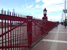
- Queens Wharf Gates, north side of Quay Street on Queens Wharf, iconic red gates and fence.[13]
- Quay Street Historic Area, south side of Quay Street East, 1874-1907, industrial buildings, offices and warehouses.[14]
- Wharf Police building, 102 Quay Street, 1903, Chelsea Sugar Refining Company headquarters 1903-1960.[15]
- Union Fish Company building, 116-118 Quay Street, 1906, car importing and engineering workshop 1906-1970s.[16]
- Northern Steamship Company building, 122-124 Quay Street, 1898, Northern Steamship Company offices 1898-1974.[17]
- Auckland Harbour Board Workshops, 204 Quay Street, 1944-1989, site spread between Lower Hobson St, Customs Street and Quay Street, repair of boats, cranes and other equipment.[18]
- Port of Auckland, container and trade port on the north side of Quay Street.
- Auckland City Arena, south side, 2007, sports and entertainment centre.
References[]
- ^ a b "Statistical area 1 dataset for 2018 Census". Statistics New Zealand. March 2020. Quay Street-Customs Street (133300). 2018 Census place summary: Quay Street-Customs Street
- ^ "General Assembly". New Zealand Herald. 29 July 1878. p. 3.
- ^ "Untitled". Auckland Star. 21 November 1878. p. 2.
- ^ "New Buildings at Queen-Street Wharf". New Zealand Herald. 6 December 1879. p. 6.
- ^ "Local and General News". New Zealand Herald. 22 April 1916. p. 6.
- ^ Bush, Graham W. A. (1991). Advance in Order: The Auckland City Council from Centenary to Reorganisation 1971-1989. Auckland City Council. pp. 80–82. ISBN 0-908834-03-9.
- ^ "Harbour Historic Area". Register of Historic Places. Heritage New Zealand. Retrieved 22 July 2020.
- ^ "Launch Offices". Register of Historic Places. Heritage New Zealand. Retrieved 22 July 2020.
- ^ "First World War Memorial Beacon". Register of Historic Places. Heritage New Zealand. Retrieved 22 July 2020.
- ^ "Wharf Pavilions (Two Buildings)". Register of Historic Places. Heritage New Zealand. Retrieved 22 July 2020.
- ^ "Ferry Building". Register of Historic Places. Heritage New Zealand. Retrieved 22 July 2020.
- ^ "Queens Wharf". Register of Historic Places. Heritage New Zealand. Retrieved 22 July 2020.
- ^ "Queens Wharf Gates". Register of Historic Places. Heritage New Zealand. Retrieved 22 July 2020.
- ^ "Quay Street Historic Area". Register of Historic Places. Heritage New Zealand. Retrieved 22 July 2020.
- ^ "Wharf Police Building". Register of Historic Places. Heritage New Zealand. Retrieved 22 July 2020.
- ^ "Union Fish Company Building". Register of Historic Places. Heritage New Zealand. Retrieved 22 July 2020.
- ^ "Northern Steamship Company Building". Register of Historic Places. Heritage New Zealand. Retrieved 22 July 2020.
- ^ "Auckland Harbour Board Workshops". Register of Historic Places. Heritage New Zealand. Retrieved 22 July 2020.

- Streets in Auckland
- Auckland CBD
- Auckland waterfront