Quebeck, Tennessee
Quebeck, Tennessee | |
|---|---|
Unincorporated community | |
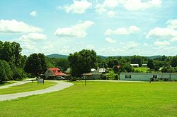 View from the Quebeck Community Center | |
 Quebeck, Tennessee | |
| Coordinates: 35°49′00″N 85°34′01″W / 35.81667°N 85.56694°WCoordinates: 35°49′00″N 85°34′01″W / 35.81667°N 85.56694°W | |
| Country | United States |
| State | Tennessee |
| County | White |
| Elevation | 899 ft (274 m) |
| Time zone | UTC-6 (Central (CST)) |
| • Summer (DST) | UTC-5 (CDT) |
| ZIP code | 38579 |
| Area code(s) | 931 |
| GNIS feature ID | 1298751[1] |


Quebeck is an unincorporated community in White County, Tennessee, United States. It is located just off U.S. Route 70, southwest of Doyle and northeast of Rock Island, and roughly adjacent to Walling. Quebeck had a post office with ZIP code 38579.[2]
The community was founded in the late 1880s by J.S. Cooper, a local sawmill owner. He named it for the Canadian province of Quebec, having been inspired by his travels there.[3]
References[]
- ^ "US Board on Geographic Names". United States Geological Survey. 2007-10-25. Retrieved 2008-01-31.
- ^ ZIP Code Lookup Archived June 15, 2011, at the Wayback Machine
- ^ Alan Rayburn, Naming Canada: Stories about Canadian Place Names (University of Toronto Press, 2001), p. 137.
Municipalities and communities of White County, Tennessee, United States | ||
|---|---|---|
| City | ||
| Town | ||
| CDPs | ||
| Other communities | ||
| ||
This White County, Tennessee geography–related article is a stub. You can help Wikipedia by . |
Categories:
- Unincorporated communities in White County, Tennessee
- Unincorporated communities in Tennessee
- Middle Tennessee geography stubs