Queen Charlotte Sound (Canada)
| Queen Charlotte Sound | |
|---|---|
| French: Bassin de la Reine-Charlotte | |
 Queen Charlotte Sound | |
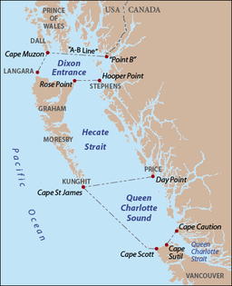 Queen Charlotte Sound as delineated by BCGNIS, along with Hecate Strait and Dixon Entrance. Red dots indicate capes and points, grey text indicates island names. | |
| Location | British Columbia, Canada |
| Coordinates | 51°30′N 129°00′W / 51.500°N 129.000°WCoordinates: 51°30′N 129°00′W / 51.500°N 129.000°W |
| Ocean/sea sources | Pacific Ocean |
| Max. length | 200 km (120 mi) |
| Max. width | 135 km (84 mi) |

Queen Charlotte Sound (French: Bassin de la Reine-Charlotte) is a sound of the Pacific Ocean in British Columbia, Canada, between Vancouver Island in the south and Haida Gwaii in the north. It merges with Hecate Strait in the north and Queen Charlotte Strait in the south.[1]
Queen Charlotte Sound is part of the Inside Passage shipping route.
Definition[]
According to the BCGNIS, the northern boundary of Queen Charlotte Sound is defined as a line running from the southernmost point of Price Island to Cape St James on Kunghit Island, the southernmost point of Haida Gwaii. The western boundary is a line from Cape St James to Cape Scott at the north end of Vancouver Island. The southern boundary runs along the coast of Vancouver Island from Cape Scott to Cape Sutil, then to Cape Caution on the mainland. An older definition placed the northern boundary as a line from the southernmost point of Aristazabal Island to Cape St James.[2]
History[]
Queen Charlotte Sound was named by James Strange on August 5, 1786, in honour of Charlotte of Mecklenburg-Strelitz, the wife of King George III. Strange was the leader of a fur trading expedition of two vessels, Captain Cook, under Captain Henry Lawrie, and Experiment, under Captain John Guise.[3] During a boat excursion up Goletas Channel Strange saw an opening ahead and named it Queen Charlotte Sound. The body of water he named was what is today known as Queen Charlotte Strait. For some time Queen Charlotte Strait was also called Queen Charlotte Sound, until 1920 when the BCGNIS and Hydrographic Service distinguished between Queen Charlotte Sound and Queen Charlotte Strait.[4] George Vancouver, who used the name in his maps and writings, wrote that the sound was named by Mr. S. Wedgeborough, in command of the Experiment under James Strange, but Vancouver was wrong—Strange was the one who gave the name.[5] [3][4]
References[]
- ^ Queen Charlotte Sound Archived March 19, 2006, at the Wayback Machine, Columbia Gazetteer of North America
- ^ "Queen Charlotte Sound". BC Geographical Names.
- ^ Jump up to: a b Pethick, Derek (1976). First Approaches to the Northwest Coast. Vancouver: J.J. Douglas. pp. 81, 88. ISBN 0-88894-056-4.
- ^ Jump up to: a b "Queen Charlotte Strait". BC Geographical Names.
- ^ Roberts, John E. (2005). A Discovery Journal: George Vancouver's First Survey Season - 1792. Trafford Publishing. pp. 213, 319. ISBN 978-1-4120-7097-3.[self-published source]
External links[]
![]() Media related to Queen Charlotte Sound (Canada) at Wikimedia Commons
Media related to Queen Charlotte Sound (Canada) at Wikimedia Commons
| show Authority control |
|---|
This article about a location on the Coast of British Columbia, Canada is a stub. You can help Wikipedia by . |
- Bays of British Columbia
- Central Coast of British Columbia
- Sounds of British Columbia
- British Columbia Coast geography stubs