R561 road (Ireland)
 | ||||
|---|---|---|---|---|
| Bóthar R561 | ||||
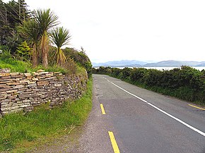 R561 on Dingle Bay near Annascaul | ||||
| Route information | ||||
| Length | 38.1 km[1][2] (23.7 mi) | |||
| Major junctions | ||||
| From | ||||
| ||||
| To | ||||
| Highway system | ||||
| ||||
The R561 road is a regional road in Ireland. It is on the Dingle Peninsula in County Kerry.[1][2] Part of the road is on the Wild Atlantic Way.[3]
, beginning at the R561, is a wide, sandy beach 6 km (4 mi) long. The beach dunes have yielded archaeological remains of ancient dwelling sites.[4]
The R561 travels west from the N22 at Farranfore. The road joins the N70 from Brackhill to Castlemaine. The R561 continues west from Castlemaine along the north shore of Castlemaine Harbour to and Inch Beach. The road then travels along the north shore of Dingle Bay before joining the N86 near Annascaul. The R561 is 38.1 km (23.7 mi) long.[1]
References[]
- ^ a b c Google (13 May 2016). "R561 to R561" (Map). Google Maps. Google. Retrieved 13 May 2016.
- ^ a b "S.I. No. 54/2012 – Roads Act 1993 (Classification of Regional Roads) Order 2012". Government of Ireland. 28 February 2012. Retrieved 13 May 2016.
- ^ "Wild Atlantic Way: Explore The Route". Fáilte Ireland. Retrieved 13 May 2016.
- ^ Poole, Susan; Gallagher, Lyn (2008). AA Best Drives Ireland. The Automobile Association. p. 33. ISBN 978-0-7495-4430-0.
This article related to the geography of County Kerry, Ireland is a stub. You can help Wikipedia by . |
This Irish road or road transport-related article is a stub. You can help Wikipedia by . |
- Regional roads in the Republic of Ireland
- Roads in County Kerry
- County Kerry geography stubs
- Ireland road stubs