Rainbow Bridge (Texas)
Port Arthur-Orange Bridge | |
U.S. National Register of Historic Places | |
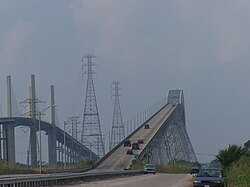 Westbound approach to Rainbow Bridge | |
 Port Arthur-Orange Bridge | |
| Location | |
|---|---|
| Coordinates | 29°58′47″N 93°52′18″W / 29.97972°N 93.87167°WCoordinates: 29°58′47″N 93°52′18″W / 29.97972°N 93.87167°W |
| Area | 4.8 acres (1.9 ha) |
| Built | 1936 |
| Built by | Union Bridge and Construction, Fort Pitt Bridge Works, et al. |
| Architectural style | Cantilever through truss |
| MPS | Historic Bridges of Texas MPS |
| NRHP reference No. | 96001127[1] |
| Added to NRHP | October 10, 1996 |


The Rainbow Bridge is a through truss bridge crossing the Neches River in Southeast Texas just upstream from Sabine Lake. It allows State Highway 87 and State Highway 73 to connect Port Arthur in Jefferson County on the southwest bank of the river. Bridge City in Orange County is on the northeast bank.
Construction[]
Construction on the bridge began in 1936 under the guidance of the Texas State Highway Department. Due to concerns by the upstream city of Beaumont about the bridge posing a threat to ship navigation, the Rainbow Bridge was built with a 680-foot (210 m) main span. In addition, it has a vertical clearance of 177 ft (54 m),[2] which was intended to allow what was at the time the tallest ship in the U.S. Navy, USS Patoka, passage under the bridge (however, Patoka never did). However, the height of the bridge did allow the construction of jack up offshore drilling rigs at the Bethlehem Steel Beaumont Shipyard. With seventy-two rigs built, the shipyard was one of the major sources of offshore rigs built in the United States.[3]
The bridge was completed on September 8, 1938. The nearby town of Prairie View took on the name "Bridge City" in response. Initially named the Port Arthur-Orange Bridge, it received its current name in 1957. The bridge was listed in the National Register of Historic Places in 1996.
Veterans Memorial Bridge[]
In 1988, construction began on the Veterans Memorial Bridge, a cable-stayed bridge. This bridge runs parallel to the Rainbow Bridge, and was dedicated on September 8, 1990.[4] With a vertical clearance of 143 feet (44 m), the bridge is somewhat shorter than its neighbor.[5]
After the completion of the Veterans Memorial Bridge, the Rainbow Bridge was closed for renovations. On its re-opening in 1997,[6] the Rainbow Bridge became one way, handling westbound traffic only. The Veterans Memorial Bridge serves eastbound traffic.[7]
See also[]
- List of bridges documented by the Historic American Engineering Record in Texas
- List of bridges on the National Register of Historic Places in Texas
- National Register of Historic Places listings in Jefferson County, Texas
References[]
- ^ "National Register Information System". National Register of Historic Places. National Park Service. November 2, 2013.
- ^ "TxDOT Trivia and General Facts". 7 October 2006. Archived from the original on 7 October 2006.CS1 maint: bot: original URL status unknown (link)
- ^ "Drilling Rigs Built in U.S. Shipyards". ShipbuildingHistory.com. Retrieved November 9, 2015.
- ^ "History of Our Bridges". City of Bridge City. Retrieved 2013-06-14.
- ^ "Bridge City Texas". Ohwy.com. Retrieved 2011-08-19.
- ^ "Rainbow Bridge (Texas)". memim.com.
- ^ "Archived copy". Retrieved January 29, 2005.
External links[]
 Media related to Rainbow Bridge at Wikimedia Commons
- Rainbow Bridge from the Handbook of Texas Online
- Historic American Engineering Record (HAER) No. TX-43, "Rainbow Bridge, Spanning Neches River at State Highway 87, Port Arthur, Jefferson County, TX", 10 photos, 1 color transparency, 2 data pages, 1 photo caption page
- Rainbow Bridge at Structurae

- Bridges completed in 1938
- Bridges completed in 1990
- Road bridges on the National Register of Historic Places in Texas
- Buildings and structures in Jefferson County, Texas
- Buildings and structures in Orange County, Texas
- Cable-stayed bridges in the United States
- Truss bridges in the United States
- Historic American Engineering Record in Texas
- Transportation in Jefferson County, Texas
- Transportation in Orange County, Texas
- Road bridges in Texas
- National Register of Historic Places in Orange County, Texas
- Steel bridges in the United States
- 1936 establishments in Texas
- Public Works Administration in Texas