Rakaia
Rakaia | |
|---|---|
town | |
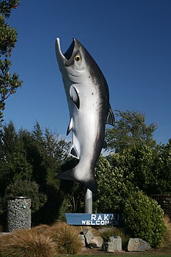 The Big Salmon of Rakaia | |
 Rakaia | |
| Coordinates: 43°45′S 172°01′E / 43.750°S 172.017°ECoordinates: 43°45′S 172°01′E / 43.750°S 172.017°E | |
| Country | |
| Region | Canterbury |
| Territorial authority | Ashburton District |
| Population (June 2020)[1] | |
| �� Total | 1,510 |

Rakaia is a town seated close to the southern banks of the Rakaia River on the Canterbury Plains in New Zealand's South Island, approximately 57 km south of Christchurch on State Highway 1 and the Main South Line. Immediately north of the township are New Zealand's longest road bridge and longest rail bridge, both of which cross the wide shingle beds of the braided river at this point. Both bridges are approximately 1750 metres in length.
Rakaia was also the junction of the Methven Branch, a branch line railway to Methven that operated from 1880 until its closure in 1976. An accident at the railway station in 1899 killed four people.[2]
Rakaia's most obvious feature is a large fibreglass salmon. The river from which the town takes its name is known for its salmon fishing and jetboating.
The town and river were previously known as Cholmondeley,[3] but the Maori name would eventually prevail over the English one.
The rural community of Acton is located south of the Rakaia township.[4]
Demographics[]
In 2006, Rakaia had a population of 1071, growing to 1272 in 2013 and 1440 in 2018. The median age of the residents in 2018 was 42.3 years old. In terms of ethnicity, 86.9% of residents identified as European, 12.9% identified as Maori and 16.2% identified as of Maori descent. The majority of residents were born in New Zealand (87.3%). The majority of residents identified with no religion (53.1%) while a sizeable minority (34.8%) identified as Christian. The majority (55.8%) of residents were in full-time employment. The median income was $33,500 with 11.8% earning over $70,000.[5]
In 2018, there were 582 occupied private dwellings and a further 72 unoccupied private dwellings.[6]
Notable buildings[]
Rakaia Post Office[]

The Rakaia Post Office was built in 1910.[7]
Bank of New Zealand[]

The Rakaia Bank of New Zealand building
South Rakaia Hotel[]
The South Rakaia Hotel is almost 150 years old.[8]

Rakaia War Memorial[]

St Andrews Presbyterian Church[]

References[]
- ^ "Population estimate tables - NZ.Stat". Statistics New Zealand. Retrieved 22 October 2020.
- ^ McLintock, A. H. (1966). "Rakaia Railway Accident". An Encyclopaedia of New Zealand. Retrieved 27 November 2011.
- ^ "Names of Places, Fights for Priority". The New Zealand Herald. 1 May 1934. Retrieved 24 June 2018.
- ^ Acton, New Zealand on GeoNames.org
- ^ "2018 Census place summaries | Stats NZ". www.stats.govt.nz. Retrieved 16 October 2020.
- ^ "2018 Census place summaries | Stats NZ". www.stats.govt.nz. Retrieved 16 October 2020.
- ^ "PRESS, VOLUME LXVII, ISSUE 14018, 15 APRIL 1911". paperspast.natlib.govt.nz. Retrieved 18 October 2020.
- ^ "The Country Pub: The South Rakaia Hotel". Stuff. 29 December 2014. Retrieved 18 October 2020.
External links[]
| Wikimedia Commons has media related to Rakaia. |
| show Authority control |
|---|
This Canterbury Region-related geography article is a stub. You can help Wikipedia by . |
- Ashburton District
- Populated places in Canterbury, New Zealand
- Canterbury, New Zealand geography stubs