Ramcat Historic District
Ramcat Historic District | |
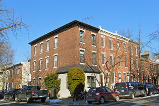
 South 25th, Ramcat Historic District, February 2014 | |
 | |
| Location | Roughly bounded by Market, Twenty-third, and Bainbridge Sts., and RR yards, Philadelphia, Pennsylvania |
|---|---|
| Coordinates | 39°56′55″N 75°10′54″W / 39.94861°N 75.18167°WCoordinates: 39°56′55″N 75°10′54″W / 39.94861°N 75.18167°W |
| Area | 48 acres (19 ha) |
| Architect | Multiple |
| Architectural style | Late 19th And 20th Century Revivals, Late Victorian, Federal |
| NRHP reference No. | 86000055[1] |
| Added to NRHP | January 8, 1986 |


Ramcat Historic District, also known as the Schuylkill Historic District, is a national historic district located in the Rittenhouse Square West neighborhood of Philadelphia, Pennsylvania. It encompasses 613 contributing buildings. It includes a mix of transportation-related, residential, and industrial properties. The mid- to late-19th century housing stock is characterized as two-story, rowhouse dwellings for the working class. Notable non-residential buildings include the Wanamaker delivery garage, Gimbel's delivery garage, Lanston Monotype Co., Lippincott and Co. Press Building, Thornton-Fuller Auto Assembly Plant (1925), Crane Ice Cream Co. (1904, 1914), and the New York Pie Baking Co.[2]
It was added to the National Register of Historic Places in 1986.[1]
25th and Pine Streets

25th and Panama

Pine Street


References[]
- ^ a b "National Register Information System". National Register of Historic Places. National Park Service. July 9, 2010.
- ^ "National Historic Landmarks & National Register of Historic Places in Pennsylvania" (Searchable database). CRGIS: Cultural Resources Geographic Information System. Note: This includes George E. Thomas (July 1985). "National Register of Historic Places Inventory Nomination Form: Ramcat Historic District" (PDF). Retrieved 2012-06-16.
| Topics |  | |
|---|---|---|
| Lists by county |
| |
| Lists by city | ||
| Other lists | ||
| ||
This article about a property in Philadelphia, Pennsylvania on the National Register of Historic Places is a stub. You can help Wikipedia by . |
- Buildings and structures on the National Register of Historic Places in Philadelphia
- Historic districts in Philadelphia
- Rittenhouse Square, Philadelphia
- Historic districts on the National Register of Historic Places in Pennsylvania
- Philadelphia County, Pennsylvania Registered Historic Place stubs