Ramco, South Australia
| Ramco South Australia | |||||||||||||||
|---|---|---|---|---|---|---|---|---|---|---|---|---|---|---|---|
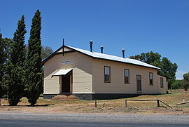 Institute, built in 1927 | |||||||||||||||
 Ramco | |||||||||||||||
| Coordinates | 34°10′18″S 139°56′40″E / 34.171594°S 139.94458°ECoordinates: 34°10′18″S 139°56′40″E / 34.171594°S 139.94458°E[1] | ||||||||||||||
| Population | 166 (2016 census)[2] | ||||||||||||||
| Postcode(s) | 5322 | ||||||||||||||
| Location | |||||||||||||||
| LGA(s) | District Council of Loxton Waikerie | ||||||||||||||
| County | Albert[1] | ||||||||||||||
| State electorate(s) | Chaffey[3] | ||||||||||||||
| Federal division(s) | Barker[4] | ||||||||||||||
| |||||||||||||||
| Footnotes | [5] | ||||||||||||||

Ramco is a town in the Riverland region of South Australia 170 kilometres (110 mi) north-east of the state capital, Adelaide and 7 kilometres (4.3 mi) west of Waikerie. At the 2016 census, Ramco had a population of 166.[2] It is on the south (left) bank of the Murray River downstream from Waikerie.
Ramco has a post office, a Lutheran church, a town hall and a school, Ramco Primary School. The current town was surveyed in 1940[5] however there was an earlier village settlement by the same name in the same area, settled in 1894.
The name Ramco is derived from an Aboriginal word "Bogorampko", a mythical tribe supposed to be superior to all natives.[5] The locality includes the Ramco Lagoon adjacent to the river, but the adjoining Ramco Point Conservation Park is in the adjacent locality of Sunlands.
Ramco is located within the federal division of Barker, the state electoral district of Chaffey and the local government area of the District Council of Loxton Waikerie.[4][3][1]
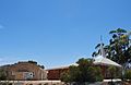
Lutheran Church & Hall

References[]
| Wikimedia Commons has media related to Ramco, South Australia. |
- ^ a b c "Search result for Ramco, LOCB' with the following datasets selected - 'Local Government areas', 'SA Government Regions', 'Counties', 'Postcode', 'Suburbs and Localities', 'Land Development Plan Zone Categories' and 'Gazetteer'". Retrieved 25 March 2018.
- ^ a b Australian Bureau of Statistics (27 June 2017). "Ramco". 2016 Census QuickStats. Retrieved 26 March 2018.

- ^ a b "District of Chaffey Background Profile". Electoral Commission SA. Retrieved 17 September 2015.
- ^ a b "Federal electoral division of Barker, boundary gazetted 16 December 2011" (PDF). Australian Electoral Commission. Retrieved 17 September 2015.
- ^ a b c "Placename Details: Ramco". Property Location Browser. Land Services Group, Department of Planning, Transport and Infrastructure. 29 October 2012. SA0000316. Retrieved 29 January 2015.
This South Australia geography article is a stub. You can help Wikipedia by . |
- Towns in South Australia
- South Australia geography stubs