Rampe de Laffrey
This article uses bare URLs, which may be threatened by link rot. (August 2021) |
The Rampe de Laffrey (sometimes called the descente de Laffrey or the côte de Laffrey) is a section of France's , today called the Route Napoléon, located in the department of Isère between the communes of Laffrey and Vizille, about fifteen kilometers southeast of Grenoble. It is a steep and mostly relatively straight section of road which ends in a sharp turn, and is known for the high number of fatal automobile accidents which have occurred along its route. Four of these, in 1946, 1973, 1975, and 2007, and all affecting buses of pilgrims returning from Notre Dame de la Salette, are counted among the deadliest in French history.
Design of the ramp[]
The slope begins in the center of the village of Laffrey at a height of 910 meters, right on the edge of the Matheysine plateau. It then goes downhill along the mountainside, passing as it does through the territory of Saint-Pierre-de-Mésage and Notre-Dame-de-Mésage, before veering strongly to the right before the bridge over the Romanche and entering the town of Vizille at an altitude of 300 meters; between these two locations, 7.5 kilometers apart, the slope descends just over 600 meters. The road is only slightly sinuous, but at its beginning contains many broad turns while remaining relatively stable near its end. Its steep slope is its most notable feature, averaging 12% along its lower portion and 16 to 18% in some places; just before the bridge at the Romanche it finishes with a 110° turn.[1] As a consequence of its design, the road was used for testing Berliet trucks until 1970.[1] It was also used as a route for motorcycle races beginning in 1960, and at one time was considered as a possibility for an Alpine stage of the Tour de France.[1]
Reconfiguration to July 2007[]

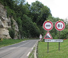
After a pair of accidents in the 1970s, heavy work was done on the route to make it more suitable for light vehicles, as reconfiguration for load-bearing vehicles, and for buses, was considered too expensive and difficult to achieve. The road was widened, and portions were expanded to three lanes near the summit. A strict prohibition was enforced, altogether banning vehicles which weigh more than eight tons and forbidding buses, except on local and regular routes, from using the road without authorization from the local prefect.[2] Local and regular service is only allowed on specially-designed vehicles with speed-reducers. Buses and trucks coming from the regular route must turn off at La Mure and take secondary road 529 past the massif of towards Grenoble. Still, many violations of the rule have been noted.[2] To discourage drivers, a sign with a skull with flickering eyes was formerly installed at the top of the road;[3] this, however, was soon removed because it was viewed in poor taste and as politically incorrect.[citation needed]
Modifications after the accident of July 22, 2007[]
On July 25, 2007, as a result of the most recent accident on the ramp, French Prime Minister François Fillon held a press conference to announce a series of measures to prevent such a heavy vehicle from attempting the descent again. Flashing signs were installed within days, as were speed bumps at the level of the road signs, designed to ensure driver attention to these signs. In July 2008, height gauges were also set up to physically prevent access for vehicles over a certain height. Authorised vehicles, such as local buses equipped with an improved braking system, are issued with a magnetic card allowing them to bypass the height gauge.
Accidents[]
Many accidents have taken place along this stretch of road; between 1946 and 2007, at least 150 deaths were recorded at the site. It is the deadliest portion of roadway anywhere in France.
- In 1946, a bus transporting pilgrims from Our Lady of La Salette crashed into a ravine, killing 18; today a memorial to the dead stands along the roadside near Saint-Pierre-de-Mésage.[4]
- In 1956, a Dutch bus suffered the same fate at the same place; seven were killed.
- In 1968, a truck flew off the road, killing its two occupants.
- In 1970, another bus transporting pilgrims flew over several walls before coming to a stop; five passengers, from Nord, were killed. The cause of this accident was later determined to be excessive speed.
- Another bus full of pilgrims, returning again from Our Lady of La Salette, crashed near the base of the road in 1973; 43 Belgians were killed.[5]
- In 1974, a truck without brakes hit a car, killing four.
- Another bus returning from Our Lady of La Salette crashed near the base of the road in 1975, in the same location as the previous bus; 29 were killed.[6]
- In 2007, yet another bus full of pilgrims, this time from Poland, crashed on the road, killing 26.
Appearances in Tour de France[]
The section was first included in the Tour de France in 1951 and has since featured 8 times, most recently in 2010.[7]
| Year | Stage | Category | Leader at the summit |
|---|---|---|---|
| 2010 | 10 | 1 | |
| 1989 | 18 | 2 | |
| 1987 | 20 | 1 | |
| 1984 | 17 | 1 | |
| 1971 | 11 | 2 | |
| 1970 | 13 | 2 | |
| 1954 | 18 | 2 | |
| 1951 | 21 | 2 |
References[]
- ^ Jump up to: a b c "Laffrey, une mauvaise pente", Libération, August 8, 2007
- ^ Jump up to: a b "Le car polonais était en infraction", in Le Figaro, July 23, 2007 [1]
- ^ "A Vizille, on crie au "scandale"" (in French). 20minutes.fr. 2007-07-23. Retrieved 2017-05-03.
Il y a vingt ans, un panneau avec une tête de mort dont les yeux clignotaient était installé en haut de cette descente, dont la pente atteint jusqu'à 14%, affirme une autre riveraine, Christiane Bonnard.
- ^ http://ddata.over-blog.com/xxxyyy/0/08/39/42/dauphine-libere-23-07-07-autobus-laffrey-3.pdf
- ^ "Accueil". Journal Chrétien. 10 April 2018.
- ^ http://tempsreel.nouvelobs.com/actualites/societe/20070722.OBS7710/laffrey__une_descente_meurtriere.html?idfx=RSS_societe
- ^ "La côte de Laffrey dans le Tour de France". ledicodutour.com. Retrieved 14 July 2010.

- Roads in France
- Isère