Romanche
| Romanche | |
|---|---|
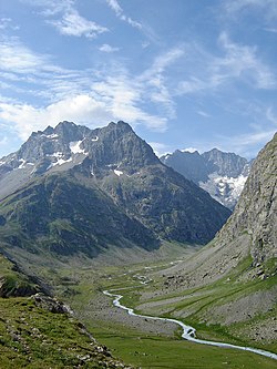 The Romanche river in Écrins National Park | |
 | |
| Location | |
| Country | France |
| Physical characteristics | |
| Source | |
| • location | Dauphiné Alps |
| • coordinates | 44°58′26″N 6°21′58″E / 44.97389°N 6.36611°E |
| • elevation | 2,140 m (7,020 ft) |
| Mouth | |
• location | Drac |
• coordinates | 45°5′23″N 5��43′33″E / 45.08972°N 5.72583°ECoordinates: 45°5′23″N 5°43′33″E / 45.08972°N 5.72583°E |
• elevation | 260 m (850 ft) |
| Length | 78.3 km (48.7 mi) |
| Basin size | 1,221 km2 (471 sq mi) |
| Basin features | |
| Progression | Drac→ Isère→ Rhône→ Mediterranean Sea |

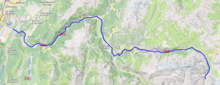
The Romanche (French pronunciation: [ʁɔmɑ̃ʃ] (![]() listen)) is a 78.3-kilometre (48.7 mi) long mountain river in southeastern France. It is a right tributary of the Drac, which is itself a tributary of the Isère.[1] Its drainage basin is 1,221 km2 (471 sq mi).[2] Its source is in the northern part of the Massif des Écrins, Dauphiné Alps. It flows into the Drac in Champ-sur-Drac, south of Grenoble. The road from Grenoble to Briançon over the Col du Lautaret runs through the Romanche valley. There are several mountain and ski resorts in the valley, including Alpe d'Huez, La Grave and Les Deux Alpes.
listen)) is a 78.3-kilometre (48.7 mi) long mountain river in southeastern France. It is a right tributary of the Drac, which is itself a tributary of the Isère.[1] Its drainage basin is 1,221 km2 (471 sq mi).[2] Its source is in the northern part of the Massif des Écrins, Dauphiné Alps. It flows into the Drac in Champ-sur-Drac, south of Grenoble. The road from Grenoble to Briançon over the Col du Lautaret runs through the Romanche valley. There are several mountain and ski resorts in the valley, including Alpe d'Huez, La Grave and Les Deux Alpes.
The Romanche flows through the following departments and towns:
References[]
- ^ Sandre. "Fiche cours d'eau - La Romanche (W27-0400)".
- ^ Bassin versant : Romanche (La), Observatoire Régional Eau et Milieux Aquatiques en PACA
External links[]
| Wikimedia Commons has media related to Romanche River. |
| hide Authority control | |
|---|---|
| General | |
| National libraries | |
This Provence-Alpes-Côte d'Azur geography article is a stub. You can help Wikipedia by . |
This Auvergne-Rhône-Alpes geographical article is a stub. You can help Wikipedia by . |
- Tributaries of the Isère
- Rivers of France
- Rivers of Provence-Alpes-Côte d'Azur
- Rivers of Auvergne-Rhône-Alpes
- Rivers of Hautes-Alpes
- Rivers of Isère
- Provence-Alpes-Côte d'Azur geography stubs
- Auvergne-Rhône-Alpes geography stubs
- France river stubs