Rapolano Terme
Rapolano Terme | |
|---|---|
| Comune di Rapolano Terme | |
 | |
 Coat of arms | |
show Location of Rapolano Terme | |
 Rapolano Terme Location of Rapolano Terme in Italy | |
| Coordinates: 43°17′N 11°36′E / 43.283°N 11.600°ECoordinates: 43°17′N 11°36′E / 43.283°N 11.600°E | |
| Country | Italy |
| Region | Tuscany |
| Province | Siena (SI) |
| Frazioni | Armaiolo, Modanella, Poggio Santa Cecilia, San Gimignanello, Serre di Rapolano |
| Government | |
| • Mayor | Emiliano Spanu |
| Area | |
| • Total | 83.04 km2 (32.06 sq mi) |
| Elevation | 334 m (1,096 ft) |
| Population (31 December 2010)[3] | |
| • Total | 5,308 |
| • Density | 64/km2 (170/sq mi) |
| Demonym(s) | Rapolanesi |
| Time zone | UTC+1 (CET) |
| • Summer (DST) | UTC+2 (CEST) |
| Postal code | 53040 |
| Dialing code | 0577 |
| Website | Official website |


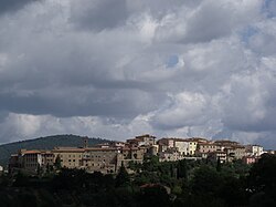
Rapolano Terme is a comune (municipality) in the Province of Siena in the Italian region Tuscany, located about 60 kilometres (37 mi) southeast of Florence and about 20 kilometres (12 mi) east of Siena in the area known as the Crete Senesi.
Until 1949 it was known simply as Rapolano.
The municipality includes several minor towns, among which the village of Serre di Rapolano.
References[]
- ^ "Superficie di Comuni Province e Regioni italiane al 9 ottobre 2011". Istat. Retrieved 16 March 2019.
- ^ "Popolazione Residente al 1° Gennaio 2018". Istat. Retrieved 16 March 2019.
- ^ All demographics and other statistics: Italian statistical institute Istat.
External links[]
| Wikimedia Commons has media related to Rapolano Terme. |

| Authority control |
|---|
Categories:
- Cities and towns in Tuscany
- Municipalities of the Province of Siena
- Crete Senesi
- Spa towns in Italy
- Province of Siena geography stubs