Ras Kebdana
Ras Kebdana | |
|---|---|
    View of Ras Kebdana with the mosque in the foreground | |
 Ras Kebdana Location in Morocco | |
| Coordinates: 35°08′N 2°25′W / 35.133°N 2.417°W | |
| Country | |
| Region | Oriental |
| Province | Nador |
| Population (2014) | |
| • Total | 7,580 |
| Time zone | UTC+0 (WET) |
| • Summer (DST) | UTC+1 (WEST) |

Ras Kebdana, Ras El Ma or Kaboyawa, is a town in Nador Province, Oriental, Morocco. It is a seaport, is located in the province of Nador, and it is not part of the Rif area in northern Morocco. According to the 2014 census, it has a population of 7,580.
History[]
The town was part of the Kingdom of Nekor around the 8th century AD.
Economy[]
For centuries, the people of Ras Kebdana lived as self-sufficient farmers from agriculture, livestock farming and fishing, which is today the most important source of income. Tourism also plays a certain role, as the east is a 6-kilometer-long sandy beach, which is visited on the weekends by day-trippers from Nador and Oujda.
Gallery[]
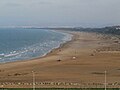
Panorama of Ras Kebdana beach

References[]
External links[]
Coordinates: 35°08′N 2°25′W / 35.133°N 2.417°W

| show Authority control |
|---|
Categories:
- Mediterranean port cities and towns in Morocco
- Rural communes of Oriental (Morocco)
- Populated places in Nador Province
- Oriental (Morocco) geography stubs