Rawdon, Quebec
Rawdon | |
|---|---|
Municipality | |
 | |
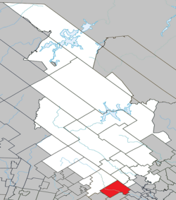 Location within Matawinie RCM. | |
 Rawdon Location in central Quebec. | |
| Coordinates: 46°03′N 73°43′W / 46.050°N 73.717°WCoordinates: 46°03′N 73°43′W / 46.050°N 73.717°W[1] | |
| Country | |
| Province | |
| Region | Lanaudière |
| RCM | Matawinie |
| Settled | 1799 |
| Constituted | May 28, 1998 |
| Government | |
| • Mayor | Bruno Guilbault |
| • Federal riding | Joliette |
| • Prov. riding | Bertrand |
| Area | |
| • Total | 193.00 km2 (74.52 sq mi) |
| • Land | 187.07 km2 (72.23 sq mi) |
| Population (2011)[3] | |
| • Total | 10,416 |
| • Density | 55.7/km2 (144/sq mi) |
| • Pop 2006-2011 | |
| • Dwellings | 5,422 |
| Time zone | UTC−5 (EST) |
| • Summer (DST) | UTC−4 (EDT) |
| Postal code(s) | J0K 1S0 |
| Area code(s) | 450 and 579 |
| Highways | |
| Website | www |

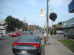
Rawdon is a municipality located on the Ouareau River in southwestern Quebec, Canada, about 60 kilometres north of Montreal. It is the seat for the Regional County Municipality of Matawinie, in the Lanaudière region. Rawdon is part of the Joliette federal electoral district.
The town of Rawdon is a mostly French-speaking tourist resort and is home to one English public school and four French public schools as well as a medium-size ski resort.
Geography[]
This section includes a list of references, related reading or external links, but its sources remain unclear because it lacks inline citations. (July 2019) |
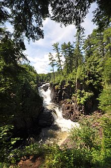
Rawdon is located at the beginning of the Canadian Shield mountains. Its lakes and mountains make it a destination for summer tourism with its many camps and cottages. Rawdon is home to the Dorwin and Manchester falls, which lie less than a kilometre from downtown and offer a public beach on the artificial Rawdon Lake. In summer, temperatures can soar as high as 35 °C (95 °F) while temperatures as cold as −30 °C (−22 °F) can be felt in winter.
History[]
This section includes a list of references, related reading or external links, but its sources remain unclear because it lacks inline citations. (July 2019) |


The township was established in 1799 and named after Sir Francis Rawdon-Hastings, 1st Marquess of Hastings. The town was primarily home to people of Irish background up until 1844, when more and more French-Canadians settled the region and small shops and industries emerged. After the First World War and the October Revolution, Rawdon saw a considerable number of Russian, Ukrainian, and Belorussian noble families arrive to settle in its countryside from the Polish–Lithuanian Commonwealth. Rawdon was originally part of Montcalm County. From 1920 to 1998, there were two separate municipalities named "Rawdon," the Township of Rawdon and the Village of Rawdon; in 1998, they were united into a single municipality.
Demographics[]
Population[]
|
|
|
In summer, the population is said to double and even sometimes triple due to tourism and the presence of many cottages in the vicinity.
Private dwellings occupied by usual residents: 4532 (total dwellings: 5422)
Language[]
Mother tongue:[3]
- English as first language: 13.5%
- French as first language: 84.8%
- English and French as first language: 1.3%
- Other as first language: 3.8%
Education[]
This section needs expansion. You can help by . (September 2017) |
Commission scolaire des Samares operates francophone public schools.
- École Ste-Anne (primary)
- École St-Louis (primary)
- École secondaire des Chutes (secondary)
Sir Wilfrid Laurier School Board operates anglophone public schools:
- Rawdon Elementary School[5]
- Joliette Elementary School
- Joliette High School in Joliette[6]
Notable people[]
- Jonathan Girard, former Boston Bruins hockey player
- Firmin Dugas (1830-1889), businessman and politician
- Martin Deschamps Canadian rock singer
See also[]
References[]
- ^ Reference number 341185 of the Commission de toponymie du Québec (in French)
- ^ Jump up to: a b Geographic code 62037 in the official Répertoire des municipalités (in French)
- ^ Jump up to: a b c Statistics Canada 2011 Census - Rawdon census profile
- ^ Statistics Canada: 1996, 2001, 2006, 2011 census
- ^ "Rawdon Elementary" Zone Map. Sir Wilfrid Laurier School Board. Retrieved on September 17, 2017.
- ^ "Joliette High School Zone Sec 1-5." Sir Wilfrid Laurier School Board. Retrieved on September 5, 2017.
External links[]
| show Adjacent Municipal Subdivisions |
|---|
| hide | |
|---|---|
| Municipalities |
|
| Parishes | |
| Unorganized Territories | |
| |
| show Authority control |
|---|
- Municipalities in Quebec
- Incorporated places in Lanaudière
- Matawinie Regional County Municipality