Rechenberg-Bienenmühle
Rechenberg-Bienenmühle | |
|---|---|
 | |
show Location of Rechenberg-Bienenmühle within Mittelsachsen district | |
 Rechenberg-Bienenmühle | |
| Coordinates: 50°44′14″N 13°32′40″E / 50.73722°N 13.54444°ECoordinates: 50°44′14″N 13°32′40″E / 50.73722°N 13.54444°E | |
| Country | Germany |
| State | Saxony |
| District | Mittelsachsen |
| Government | |
| • Mayor (2015–22) | Michael Funke[1] |
| Area | |
| • Total | 52.49 km2 (20.27 sq mi) |
| Elevation | 600 m (2,000 ft) |
| Population (2020-12-31)[2] | |
| • Total | 1,823 |
| • Density | 35/km2 (90/sq mi) |
| Time zone | UTC+01:00 (CET) |
| • Summer (DST) | UTC+02:00 (CEST) |
| Postal codes | 09623 |
| Dialling codes | 037327 |
| Vehicle registration | FG |


Rechenberg-Bienenmühle is a municipality in the district of Mittelsachsen, in Saxony, Germany.
Culture and sights[]
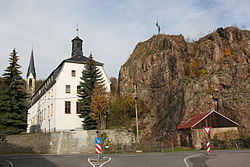
Among the most famous attractions of the place is the Saxon Brewery Museum in Rechenberg. Rechenberg-Bienenmuhle has an historic town centre, with an ensemble of well-preserved half-timbered houses, which includes the small market place, the former manor house mansion of the ruined castle, the brewery, the timber rafter's house and the old village school. In addition to the rustic double and triple-sided farmyards in the district, the village church of Clausnitz is also worth seeing because of its remarkable interior. Remnants of the old Neugrabenflöße mining canal have also survived. This waterway between the Flöha near (Fleyh) and the Freiberger Mulde, which emptied in Clausnitz into the Rachel, was used for more than 350 years for timber rafting for the Freiberg mining region.
References[]
- ^ Bürgermeisterwahlen 2015, Freistaat Sachsen, accessed 13 July 2021.
- ^ "Bevölkerung des Freistaates Sachsen nach Gemeinden am 31. Dezember 2020". Statistisches Landesamt des Freistaates Sachsen (in German). June 2021.
| show Towns and municipalities in Mittelsachsen district |
|---|
| show Authority control |
|---|
This Mittelsachsen location article is a stub. You can help Wikipedia by . |
This Ore Mountains article is a stub. You can help Wikipedia by . |
- Municipalities in Saxony
- Mittelsachsen
- Bezirk Karl-Marx-Stadt
- Mittelsachsen district geography stubs
- Ore Mountains stubs