Reddigudem mandal
Reddigudem Mandal | |
|---|---|
Mandal | |
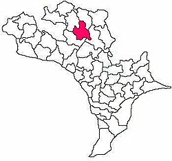 Mandal map of Krishna district showing Reddigudem mandal (in Rose Colour) | |
 Reddigudem Mandal Location in Andhra Pradesh, India | |
| Coordinates: 16°52′08″N 80°44′12″E / 16.8690°N 80.7367°ECoordinates: 16°52′08″N 80°44′12″E / 16.8690°N 80.7367°E | |
| Country | India |
| State | Andhra Pradesh |
| District | Krishna |
| Headquarters | Reddigudem |
| Government | |
| • Body | Mandal Parishad |
| Area | |
| • Total | 89.73 km2 (34.64 sq mi) |
| Population (2011) | |
| • Total | 53,540 |
| • Density | 600/km2 (1,500/sq mi) |
| Languages | |
| • Official | Telugu |
| Time zone | UTC+5:30 (IST) |
| PIN | 521 XXX |
| Vehicle registration | AP 16 |

Reddigudem mandal is one of the 50 mandals in the Krishna district of the Indian state of Andhra Pradesh.[1]
Villages[]
- Anneraopeta
- Kudapa
- Kunaparajuparva
- Maddulaparva
- Mutchinapalle
- Naguluru
- Narukullapadu
- Patha Naguluru
- Rangapuram
- Reddigudem
- Raghavapuram
- Rudravaram
- Seetharampuram
References[]
- ^ "Census 2011 Krishna district". Retrieved 6 November 2017.
Categories:
- Mandals in Krishna district
- Krishna district geography stubs