Rempart Mountain
| Rempart Mountain | |
|---|---|
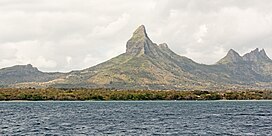 Rempart Mountain as seen in 2015 | |
| Highest point | |
| Elevation | 777 ± 5[1] m (2,549 ± 16 ft) |
| Coordinates | ~-20.3475°, ~57.3760° |
Rempart Mountain is a mountain near Tamarin in the western Mauritius district of Rivière Noire.
The mountain featured on 1950 and 1954 stamps of Mauritius.[2]
See also[]
- Rivière du Rempart (river) in north-east Mauritius.
References[]
- ^ "Important Bird Areas factsheet: Macchabé - Brise Fer forest". datazone.birdlife.org. BirdLife International (2018). Retrieved 5 March 2018.
- ^ Stanley Gibbons Stamp Catalogue: Commonwealth and British Empire Stamps 1840-1970. 111th edition. London: Stanley Gibbons, 2009, p. 412. ISBN 0852596839
Coordinates: 20°21′00″S 57°22′30″E / 20.35°S 57.375°E

This Mauritius location article is a stub. You can help Wikipedia by . |
Categories:
- Rivière Noire District
- Mountains of Mauritius
- Mauritius geography stubs