Rengit
Rengit 龙引 | |
|---|---|
Town and sub-district | |
| Other transcription(s) | |
| • Jawi | رڠيت |
| • Chinese | 龙引 |
 | |
 Flag  Seal | |
 Rengit 龙引 Location in Malaysia | |
| Coordinates: 1°40′50″N 103°08′50″E / 1.68056°N 103.14722°ECoordinates: 1°40′50″N 103°08′50″E / 1.68056°N 103.14722°E | |
| Country | Malaysia |
| State | Johor |
| City | Batu Pahat |
| Government | |
| • Local Authority | Majlis Perbandaran Batu Pahat |
| Area | |
| • Total | 645.12 km2 (249.08 sq mi) |
| Time zone | UTC+8 (MST) |
| Postcode | 83100 |
| Dialling code | +607 |
| Police | Batu Pahat |
| Fire | Batu Pahat |

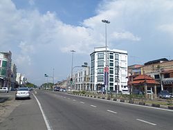
Rengit is a town and an autonomous sub-district in Mukim Sungai Kluang, Batu Pahat District, Johor, Malaysia.[2] Rengit has more than 30 villages and 25 schools.
Geography[]

The town spans over an area of 6.5 km2.[3] The area of Rengit sub-district is approximately 100.8 square miles or 64,512 hectares and divided into 3 mukims namely the Kampung Bahru, Sungai Punggur and Sungai Kluang District where each mukim is governed by a Chief. [4]
Demographic[]
The majority ethnics in Rengit are Malay with Chinese as the largest minority.
Languages[]
Main languages in this town are Bahasa Melayu, Hokkien, Mandarin and English.
Education[]
- S.B.R. Chong Hwa High School
- Sekolah Jenis Kebangsaan (C) Chong Hwa Rengit / Chong Hwa Rengit Primary School
Religion[]
The majority population practice Islam, followed by Chinese folk religion (including Taoism), Buddhism and Christianity.
Place of worship[]
- Tokong Sembilan Maharaja Dewa (龍引斗母宫), founded in 1912
- Rengit Zheng Long Gong Temple (龍引鎮龍宮)
- Rengit Presbyterian Church
Notable residents[]
- Hasanuddin Mohd Yunus, Politician
Neighbouring towns[]
Destinations from Rengit | |
|---|---|
References[]
- ^ "Profil Daerah". ptj.johor.gov.my.
- ^ Khairul Faizi A Rahman (2014). Parishes Short Info Data of Batu Pahat District. Wow Eight. p. 7.
- ^ http://jpbd.johor.gov.my/images/jpbd_DokumenTerbitan/Handbook.pdf
- ^ "Profil Daerah". Retrieved 22 May 2018.

This Johor location article is a stub. You can help Wikipedia by . |
- Towns in Johor
- Batu Pahat District
- Johor geography stubs