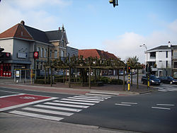
Retie
Retie | |
|---|---|
 | |
 Flag  Coat of arms | |
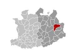
 Retie Location in Belgium
show Location of Retie in the province of Antwerp | |
| Coordinates: 51°16′N 05°04′E / 51.267°N 5.067°ECoordinates: 51°16′N 05°04′E / 51.267°N 5.067°E | |
| Country | Belgium |
| Community | Flemish Community |
| Region | Flemish Region |
| Province | Antwerp |
| Arrondissement | Turnhout |
| Government | |
| • Mayor | Patrick Geuens (NR) |
| • Governing party/ies | Nieuw Retie, N-VA |
| Area | |
| • Total | 48.39 km2 (18.68 sq mi) |
| Population (2018-01-01)[1] | |
| • Total | 11,240 |
| • Density | 230/km2 (600/sq mi) |
| Postal codes | 2470 |
| Area codes | 014 |
| Website | www.retie.be |

Retie (Dutch pronunciation: [ˈreːti]) is a municipality located in the Campine region of the province of Antwerp, Belgium. The municipality comprises the town of Retie proper and several hamlets of which Schoonbroek is the largest. On 1 January 2012 Retie had a total population of 10,799. The total area is 48.39 km2 which gives a population density of 213 inhabitants per square kilometre.
The Francophone name of Retie is Rethy.
Famous inhabitants[]
- Lodewijk de Koninck (1838–1924), writer
- Peter van Hove, (18thC.) Friar Minor
See also[]
- Princes Park, Retie, which was also a location in the award-winning tv series Flesh and Bones.
References[]
- ^ "Wettelijke Bevolking per gemeente op 1 januari 2018". Statbel. Retrieved 9 March 2019.
External links[]
 Media related to Retie at Wikimedia Commons
- Official website
| show Places adjacent to Retie |
|---|

| Authority control |
|
|---|
This Antwerp Province location article is a stub. You can help Wikipedia by . |
Categories:
- Retie
- Municipalities of Antwerp (province)
- Antwerp geography stubs