Ribera, Agrigento
This article needs additional citations for verification. (January 2021) |
Ribera | |
|---|---|
| Comune di Ribera | |
 Panorama of Ribera | |
 Coat of arms | |
show Location of Ribera | |
 Ribera Location of Ribera in Italy | |
| Coordinates: 37°29′58″N 13°15′54″E / 37.49944°N 13.26500°E | |
| Country | Italy |
| Region | Sicily |
| Province | Agrigento (AG) |
| Frazioni | Borgo Bonsignore, Seccagrande |
| Government | |
| • Mayor | Carmelo Pace |
| Area | |
| • Total | 118.67 km2 (45.82 sq mi) |
| Elevation | 223 m (732 ft) |
| Population (31 December 2010)[2] | |
| • Total | 19,601 |
| • Density | 170/km2 (430/sq mi) |
| Demonym(s) | Riberesi |
| Time zone | UTC+1 (CET) |
| • Summer (DST) | UTC+2 (CEST) |
| Postal code | 92016 |
| Dialing code | 0925 |
| Patron saint | St. Nicholas |
| Saint day | December 6 |
| Website | Official website |


Ribera (Sicilian: Rivela) is a comune in the province of Agrigento, Region of Sicily, southern Italy, between the Verdura and valleys in the so-called .
The town is connected by the SS115 state road, leading from Trapani to Syracuse. The Platani River, the third Sicilian river, flows nearby. It has enormously contributed to developing both farming and tourism in the area. Its mouth has been designated as a natural reserve.
History[]
The comune probably rose on the site of the ancient , to which the Byzantine necropolis near the modern town may possibly be attributed. In 1627, Luigi Guglielmo Moncada, Prince of Paternò, founded a new centre named after his wife, Maria Alfan di Ribera; the new centre developed rapidly, thanks to the fertility of the soil and the accessibility of the area.
It is the birthplace of Prime Minister Francesco Crispi.
Main sights[]
The Chiesa Madre, founded in the 18th century, facing the Piazza Duomo ("Cathedral Square"). The Town Hall (19th century) is in the same square. In Via Crispi is the house where Francesco Crispi, leader of the Italian government between 1887 and 1896, was born. The Garibaldi Garden offers a botanical itinerary.
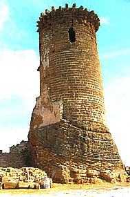
Just outside the town, on a gorge overlooking the Verdura river is the , built by in the 14th century. A Bronze Age necropolis (13th century BC) was discovered near the town. It includes some 30 tombs in two types, "chamber"- or "grotto"-like; some are preceded by a corridor up to 4 metres (13 ft) long.
Also outside the town is the , a village founded under Fascism as part of the "colonization" policy that encouraged the creation of new villages; it has now grown as a summer resort.
Economy[]
Agriculture is the commune's main industry, notably involved in the cultivation and marketing of the Washington navel orange – here introduced by emigrants returned from the United States – and strawberries. Such businesses are enhanced both by excellent climatic and environmental conditions and a supporting policy by the local authorities.
Twin towns[]
See also[]
| Wikimedia Commons has media related to Ribera (Italy). |
External links[]
| show Authority control |
|---|
- ^ "Superficie di Comuni Province e Regioni italiane al 9 ottobre 2011". Istat. Retrieved 16 March 2019.
- ^ "Popolazione Residente al 1° Gennaio 2018". Istat. Retrieved 16 March 2019.
- Cities and towns in Sicily
- Municipalities of the Province of Agrigento