Riddoch Highway
Riddoch Highway | |
|---|---|
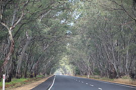 | |
Riddoch Highway near Padthaway | |
 | |
| General information | |
| Type | Highway |
| Length | 239 km (149 mi) |
| Route number(s) |
|
| Major junctions | |
| North end | Keith, South Australia |
| |
| South end | Sea Parade Port MacDonnell, South Australia |
| Location(s) | |
| Major settlements | Padthaway, Naracoorte, Coonawarra, Penola, Tarpeena, Mount Gambier |
| Highway system | |
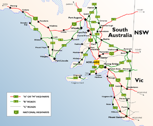
The Riddoch Highway in south-eastern South Australia branches from the Dukes Highway at Keith and travels south through Padthaway, Naracoorte, Penola, Nangwarry, Tarpeena, and Mount Gambier to Port MacDonnell and nearby Cape Northumberland.[1]
The highway has been designated as State Route A66 between Keith and Mount Gambier. The remainder, between Mount Gambier and Port MacDonnell has been labelled State Route B66, although this is not officially known as the Riddoch Highway.
It passes through grazing and cereal-growing land, horticultural and vineyards (within the following wine regions - Padthaway, Wrattonbully, Coonawarra and Mount Gambier), and plantation timber, predominantly pinus radiata.[2]
The Royal Automobile Association of South Australia has rated the highway at 5/10.[3]
The Riddoch Highway is named after John Riddoch, the first white settler landholder and vigneron in Coonawarra.
Major intersections[]
| LGA | Location | km[4] | mi | Destinations | Notes |
|---|---|---|---|---|---|
| Tatiara | Keith | 0.0 | 0.0 | ||
| Naracoorte Lucindale | The Gap, Cadgee, Lochaber, Keppoch | 83.5 | 51.9 | ||
| Naracoorte | 109 | 68 | |||
| Wattle Range | 141 | 88 | |||
| Penola | 159 | 99 | |||
| Mount Gambier | Mount Gambier | 210 | 130 | ||
| Grant | Port MacDonnell | 238 | 148 | Cape Northumberland | |
| 1.000 mi = 1.609 km; 1.000 km = 0.621 mi | |||||
See also[]
![]() Australian Roads portal
Australian Roads portal
References[]
- ^ "Naming of State Rural Roads South East (RACK PLAN 994)" (PDF). Department of Planning, Transport and Infrastructure. Retrieved 18 November 2014.
- ^ Longbottom, Mardi; Maschmedt, David and Pichler, Markus (2011), Unearthing viticulture in the Limestone Coast (PDF), p. 12, ISBN 978-0-646-56744-0, archived from the original (PDF) on 6 November 2014, retrieved 5 November 2014CS1 maint: multiple names: authors list (link)
- ^ "roadwatch report – riddoch highway" (PDF). RAA. September 2006. Retrieved 16 October 2007.
- ^ Google (6 February 2018). "Riddoch Highway" (Map). Google Maps. Google. Retrieved 6 February 2018.
External links[]
| hide Road infrastructure in South Australia | ||
|---|---|---|
| Expressways |
| |
| Interstate highways | ||
| State highways |
| |
| Arterial roads |
| |
| Outback tracks | ||
- Highways in South Australia
- Roads in South Australia