Rio Cobre
| Rio Cobre | |
|---|---|
 The A1 road crossing the Rio Cobre via the Flat Bridge. | |
| Location | |
| Country | Jamaica |
| Region | St Catherine |
| Physical characteristics | |
| Mouth | Caribbean Sea |
• location | Kingston Harbour |
• coordinates | 17°59′03″N 76°51′35″W / 17.9840396°N 76.8596649°WCoordinates: 17°59′03″N 76°51′35″W / 17.9840396°N 76.8596649°W |
• elevation | 0 m (0 ft) |

The Rio Cobre is a river of Jamaica. Its source is unclear,[1] the headwaters being a writhing of unnamed, seasonally dry tributaries. The highest of these rise just above the 1,750 feet (530 m) contour. From here it flows to meet the Caribbean Sea in the north west corner of Kingston Harbour. It is dammed by the Rio Cobre Dam just above Spanish Town.
The river's most significant feature is perhaps the gorge through which it runs between Bog Walk and northern Spanish Town.
Bridges[]
There are a number of bridges over the Rio Cobre. The oldest is Flat Bridge, which was first built before 1774.[2]
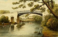
A second bridge, Iron Bridge was built in 1801. The proposal for this bridge first appeared in 1766 and the topic was discussed various bodies until 1796 the House of Assembly which originally resolved to erect a stone bridge. However technical difficulties led to an iron bridge being erected. This enabled the road to be raised above the surrounding terrain, something particularly important in the context of periodic floods in the rainy season.[3] It used the same technology developed for The Iron Bridge in Shropshire, England,[4] and indeed constituted the first application of this technology outside the United Kingdom. The iron components were pre-fabricated in West Yorkshire with a total weight of 87 tons. It took 43 horse-drawn wagons to transport these from the coast to the construction site.[4] The bridge remained in use until 2000, when erosion by storm water put its future survival in jeopardy. However funds were raised for a restoration project which restored the bridge for use by 2010.[4]
See also[]
References[]
General[]
- GEOnet Names Server
- OMC Map
- CIA Map
- Ford, Jos C. and Finlay, A.A.C. (1908).The Handbook of Jamaica. Jamaica Government Printing Office
Inline[]
- ^ UK Directorate of Overseas Surveys 1:50,000 map of Jamaica sheet K, 1966.
- ^ Long, Edward History of Jamaica (London: Frank Cas & Co. Ltd.) 1970
- ^ Hakewill, James (1825). A Picturesque Tour of the Island of Jamaica. London: Hurst and Robinson. p. 16. Retrieved 25 June 2016.
- ^ Jump up to: a b c "The Iron Bridge at Spanish Town | Completed projects | Friends of the Georgian Society of Jamaica". fgsj.org.uk. Retrieved 25 June 2016.
External links[]
| Wikimedia Commons has media related to Rio Cobre. |
| Authority control |
|
|---|
- Rivers of Jamaica
- Cast-iron arch bridges