Rip Point
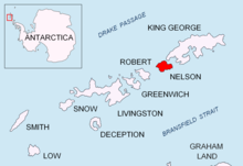
Location of Nelson Island in the South Shetland Islands.
Rip Point (62°15′S 58°59′W / 62.250°S 58.983°WCoordinates: 62°15′S 58°59′W / 62.250°S 58.983°W) is a point on Nelson Island forming the south side of the east entrance to Fildes Strait, in the South Shetland Islands. The name appears on a British Admiralty chart showing the results of a survey by DI personnel on the Discovery II in 1935.
 WikiMiniAtlas
References[]
![]() This article incorporates public domain material from the United States Geological Survey document: "Rip Point". (content from the Geographic Names Information System)
This article incorporates public domain material from the United States Geological Survey document: "Rip Point". (content from the Geographic Names Information System) ![]()
This Nelson Island, South Shetlands location article is a stub. You can help Wikipedia by . |
Categories:
- Headlands of Antarctica
- South Shetland Islands geography stubs