River Bourne, Dorset
| River Bourne | |
|---|---|
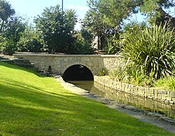 The River Bourne as it flows through Bournemouth Gardens | |
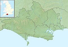 Location within Dorset | |
| Location | |
| Country | United Kingdom |
| County | Dorset |
| Physical characteristics | |
| Source | |
| • location | Dorset |
| Mouth | |
• location | Bournemouth, Dorset |
• coordinates | 50°42′58″N 1°52′26″W / 50.716°N 1.874°WCoordinates: 50°42′58″N 1°52′26″W / 50.716°N 1.874°W |

The River Bourne is a small river in Dorset, England. It flows into the English Channel at Bournemouth, taking its name simply from Middle English bourn or burn, a small stream, and giving it to the town at its mouth.[1][2]
The Bourne comprises two main tributaries totalling just over 13 kilometres (8.1 mi) of waterway; of this total length 5.7 kilometres (3.5 mi) is culverted and 7.5 kilometres (4.7 mi) is open stream. Its drainage catchment is some 14 square kilometres (5.4 sq mi), about 70% of which lies within the Borough of Poole.[3]
The stream is fed from a number of sources but there is little documentary evidence and the actual origins of some are unknown. The head of the stream consists of three culverts emerging from below Ringwood Road; it is believed that one drains Canford Heath, one is fed from the Bournemouth and West Hampshire Water works at Francis Avenue and the third is supplied by road run-off.[3] After flowing across Alderney Recreation Ground the stream is culverted for 2.4 kilometres (1.5 mi) and re-emerges at Coy Pond Gardens.[4] The stream is also fed by natural seeps and flushes, and there are 62 documented surface water discharges to the watercourse.[3]
In the upper reaches, the catchment boundaries are approximately defined by Ringwood Road to the west, Wallisdown Road to the north and Ashley Road/Poole Road to the south. In the lower reaches, the catchment width gradually narrows towards the outfall at Bournemouth Pier. The overall fall between the highest levels in the upper catchment to the Poole Bay outfall is approximately 60 metres (200 ft), giving an overall gradient of approximately 1:100 which is considered to be steep.
Reaching Bournemouth, it flows through public gardens, known as the Upper, Central and Lower Gardens. It goes underground at The Square (which divides the Central Gardens from the Lower Gardens) and again just before it reaches the beach immediately east of Bournemouth Pier, so that its mouth is no longer visible.[5]
References[]
- ^ Ashley, Harry W.; Ashley, Hugh (1990). Bournemouth 1890-1990 (a brief history of Bournemouth over the last 100 years). Bournemouth: Bournemouth Borough Council. p. 51.
- ^ Edwards, Elizabeth (1981). A History of Bournemouth. Chichester: Phillimore & Co Ltd. p. 24. ISBN 0 85033 412 8.
- ^ a b c "About the Bourne Stream". Bourne Stream Partnership. 2012. Retrieved 6 September 2013.
- ^ Ashley, Harry W.; Ashley, Hugh (1990). Bournemouth 1890-1990 (a brief history of Bournemouth over the last 100 years). Bournemouth: Bournemouth Borough Council. p. 52.
- ^ Ashley, Harry W.; Ashley, Hugh (1990). Bournemouth 1890-1990 (a brief history of Bournemouth over the last 100 years). Bournemouth: Bournemouth Borough Council. pp. 51–52.
| Unitary authorities | |
|---|---|
| Major settlements |
|
| Rivers | |
| Topics | |
- Rivers of Bournemouth
- Rivers of Poole
- Rivers of Dorset