Riverton, New Jersey
Riverton, New Jersey | |
|---|---|
| Borough of Riverton | |
 Train on the River Line | |
 Riverton highlighted in Burlington County. Inset map: Burlington County highlighted in the State of New Jersey. | |
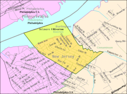 Census Bureau map of Riverton, New Jersey | |
 Riverton Location in Burlington County | |
| Coordinates: 40°00′43″N 75°00′53″W / 40.01194°N 75.01474°WCoordinates: 40°00′43″N 75°00′53″W / 40.01194°N 75.01474°W[1][2] | |
| Country | |
| State | |
| County | |
| Incorporated | December 18, 1893 |
| Government | |
| • Type | Borough |
| • Body | Borough Council |
| • Mayor | Suzanne Cairns Wells (R, term ends December 31, 2023)[3][4] |
| • Municipal clerk | Michelle Hack[5] |
| Area | |
| • Total | 0.96 sq mi (2.50 km2) |
| • Land | 0.66 sq mi (1.71 km2) |
| • Water | 0.30 sq mi (0.78 km2) 31.46% |
| Area rank | 506th of 565 in state 37th of 40 in county[1] |
| Elevation | 13 ft (4 m) |
| Population | |
| • Total | 2,779 |
| • Estimate (2019)[11] | 2,685 |
| • Rank | 458th of 566 in state 33rd of 40 in county[12] |
| • Density | 4,179.4/sq mi (1,613.7/km2) |
| • Density rank | 144th of 566 in state 5th of 40 in county[12] |
| Time zone | UTC−05:00 (Eastern (EST)) |
| • Summer (DST) | UTC−04:00 (Eastern (EDT)) |
| ZIP Codes | |
| Area code(s) | 856 exchanges: 303, 786, 829[15] |
| FIPS code | 3400563660[1][16][17] |
| GNIS feature ID | 0885373[1][18] |
| Website | www |


Riverton is a borough located in Burlington County, New Jersey, United States. As of the 2010 United States Census, the borough had a total population of 2,779,[8][9][10] reflecting an increase of 20 (+0.7%) from the 2,759 counted in the 2000 Census, which had in turn declined by 16 (-0.6%) from the 2,775 counted in the 1990 Census.[19]
Riverton was incorporated as a borough by an act of the New Jersey Legislature on December 18, 1893, from portions of Cinnaminson Township, based on the results of a referendum held six days earlier. Portions of the borough were taken to form Palmyra Township on April 19, 1894.[20] The borough's name is derived from The Riverton Improvement Company, which was established after a group of ten purchased a 120-acre (49 ha) that would be the site of a planned community with homes erected for many of the founders along the riverfront.[21]
It is a dry town, where alcohol cannot be sold.[22][23] The borough's dry status was an early character of the borough, with a clause inserted starting in 1952 by the Riverton Improvement Company into deeds for all properties in the community that prohibited the sale or manufacture of alcoholic beverages.[21][24]
The borough is located on the Delaware River and is pedestrian-friendly, with sidewalks, gas lamps, and Victorian architecture. Riverton is home to the Riverton Yacht Club, one of the oldest active yacht clubs in the country.[25] Many residents' sailboats make their home at this landmark.
History[]

Riverton was established in 1851, along the Delaware River, having been laid out by Philadelphia architect Samuel Sloan. According to architectural historian Henry Russell Hitchcock, Riverton was one of the first totally planned residential subdivisions in the United States.[26]
In 1916, Japanese beetles, now a widespread insect pest in the United States, were first discovered in a nursery near Riverton.[27]
Geography[]
According to the United States Census Bureau, the borough had a total area of 0.96 square miles (2.50 km2), including 0.66 square miles (1.71 km2) of land and 0.30 square miles (0.78 km2) of water (31.46%).[1][2]
The borough borders Cinnaminson Township and Palmyra in Burlington County; and Philadelphia, across the Delaware River in Pennsylvania.[28][29][30]
Demographics[]
| Historical population | |||
|---|---|---|---|
| Census | Pop. | %± | |
| 1880 | 582 | — | |
| 1890 | 1,075 | 84.7% | |
| 1900 | 1,332 | * | 23.9% |
| 1910 | 1,778 | 33.5% | |
| 1920 | 2,341 | 31.7% | |
| 1930 | 2,483 | 6.1% | |
| 1940 | 2,354 | −5.2% | |
| 1950 | 2,761 | 17.3% | |
| 1960 | 3,324 | 20.4% | |
| 1970 | 3,412 | 2.6% | |
| 1980 | 3,068 | −10.1% | |
| 1990 | 2,775 | −9.6% | |
| 2000 | 2,759 | −0.6% | |
| 2010 | 2,779 | 0.7% | |
| 2019 (est.) | 2,685 | [11][31] | −3.4% |
| Population sources: 1880-1890[32] 1890-2000[33] 1890-1920[34] 1890-1910[35] 1910-1930[36] 1930-1990[37] 2000[38][39] 2010[8][9][10] * = Lost territory in previous decade.[20] | |||
Census 2010[]
The 2010 United States census counted 2,779 people, 1,057 households, and 755 families in the borough. The population density was 4,179.4 per square mile (1,613.7/km2). There were 1,112 housing units at an average density of 1,672.3 per square mile (645.7/km2). The racial makeup was 93.41% (2,596) White, 3.31% (92) Black or African American, 0.11% (3) Native American, 0.76% (21) Asian, 0.07% (2) Pacific Islander, 0.47% (13) from other races, and 1.87% (52) from two or more races. Hispanic or Latino of any race were 2.02% (56) of the population.[8]
Of the 1,057 households, 29.6% had children under the age of 18; 56.6% were married couples living together; 11.2% had a female householder with no husband present and 28.6% were non-families. Of all households, 23.8% were made up of individuals and 9.3% had someone living alone who was 65 years of age or older. The average household size was 2.52 and the average family size was 3.00.[8]
21.4% of the population were under the age of 18, 6.7% from 18 to 24, 23.0% from 25 to 44, 31.0% from 45 to 64, and 17.9% who were 65 years of age or older. The median age was 44.2 years. For every 100 females, the population had 91.5 males. For every 100 females ages 18 and older there were 87.7 males.[8]
The Census Bureau's 2006-2010 American Community Survey showed that (in 2010 inflation-adjusted dollars) median household income was $94,762 (with a margin of error of +/- $6,688) and the median family income was $112,721 (+/- $9,113). Males had a median income of $81,078 (+/- $9,544) versus $50,517 (+/- $6,553) for females. The per capita income for the borough was $47,945 (+/- $4,715). About 3.4% of families and 4.2% of the population were below the poverty line, including 5.4% of those under age 18 and 2.4% of those age 65 or over.[40]
Census 2000[]
As of the 2000 United States Census[16] there were 2,759 people, 1,066 households, and 746 families residing in the borough. The population density was 4,205.1 people per square mile (1,614.0/km2). There were 1,113 housing units at an average density of 1,696.4 per square mile (651.1/km2). The racial makeup of the borough was 95.83% White, 1.78% African American, 0.11% Native American, 0.83% Asian, 0.00% Pacific Islander, 0.29% from other races, and 1.16% from two or more races. 1.09% of the population were Hispanic or Latino of any race.[38][39]
There were 1,066 households, out of which 30.7% had children under the age of 18 living with them, 58.7% were married couples living together, 8.4% had a female householder with no husband present, and 30.0% were non-families. Another 25.3% of all households were made up of individuals, and 8.1% had someone living alone who was 65 years of age or older. The average household size was 2.48 and the average family size was 3.00.[38][39]
In the borough the population was spread out, with 21.8% under the age of 18, 4.3% from 18 to 24, 29.8% from 25 to 44, 24.8% from 45 to 64, and 19.3% who were 65 years of age or older. The median age was 42 years. For every 100 females, there were 90.3 males. For every 100 females age 18 and over, there were 88.8 males.[38][39]
The median income for a household in the borough was $58,977, and the median income for a family was $68,125. Males had a median income of $50,950 versus $36,042 for females. The per capita income for the borough was $30,223. 3.1% of the population and 2.0% of families were below the poverty line. Out of the total population, 4.5% of those under the age of 18 and 2.4% of those 65 and older were living below the poverty line.[38][39]
Government[]
Local government[]
Riverton is governed under the Borough form of New Jersey municipal government, which is used in 218 of 565 municipalities (of the 565) statewide, making it the most common form of government in New Jersey.[41] The governing body is comprised of a Mayor and a Borough Council, with all positions elected at-large on a partisan basis as part of the November general election. A Mayor is elected directly by the voters to a four-year term of office. The Borough Council is comprised of six members elected to serve three-year terms on a staggered basis, with two seats coming up for election each year in a three-year cycle.[6] The Borough form of government used by Riverton is a "weak mayor / strong council" government in which council members act as the legislative body with the mayor presiding at meetings and voting only in the event of a tie. The mayor can veto ordinances subject to an override by a two-thirds majority vote of the council. The mayor makes committee and liaison assignments for council members, and most appointments are made by the mayor with the advice and consent of the council.[42][43]
As of 2020, the Mayor of Riverton is Republican Suzanne Cairns Wells, whose term of office ends December 31, 2023. Members of the Riverton Borough Council are Council President William Corbi (R, 2021), Hank DeGeorge (R, 2021), Kirk Fullerton (R, 2022), Laura Major (R, 2022), Kenneth Mills (R, 2020) and James Quinn (D, 2020).[3][44][45][46][47]
In January 2016, the Borough Council selected Kirk Fullerton from three names nominated by the Republican municipal committee to fill the seat expiring in December 2016 that was vacated by Susan Cairns Wells when she took office as mayor.[48]
Federal, state and county representation[]
Riverton is located in the 3rd Congressional District[49] and is part of New Jersey's 7th state legislative district.[9][50][51] Prior to the 2010 Census, Riverton had been part of the 1st Congressional District, a change made by the New Jersey Redistricting Commission that took effect in January 2013, based on the results of the November 2012 general elections.[52]
For the 117th United States Congress, New Jersey's 3rd Congressional District is represented by Andy Kim (D, Bordentown).[53] New Jersey is represented in the United States Senate by Democrats Cory Booker (Newark, term ends 2027)[54] and Bob Menendez (Harrison, term ends 2025).[55][56]
For the 2018–2019 session (Senate, General Assembly), the 7th Legislative District of the New Jersey Legislature is represented in the State Senate by Troy Singleton (D, Palmyra) and in the General Assembly by Herb Conaway (D, Moorestown) and Carol A. Murphy (D, Mount Laurel).[57][58]
Burlington County is governed by a board of chosen freeholders, whose five members are elected at-large in partisan elections to three-year terms of office on a staggered basis, with either one or two seats coming up for election each year; at an annual reorganization meeting, the board selects a director and deputy director from among its members.[59] As of 2018, Burlington County Board of Chosen Freeholders are Director Kate Gibbs (R, Lumberton Township, term as freeholder and as director ends December 31, 2018),[60] Deputy Director Linda Hughes (R, Evesham Township, term as freeholder and as deputy director ends 2018)[61] Tom Pullion (D, Edgewater Park, 2020),[62] Balvir Singh (D, Burlington Township, 2020),[63] and Latham Tiver (R, Southampton Township, 2019).[64][59][65][66] Burlington County's Constitutional Officers are County Clerk Tim Tyler (R, Fieldsboro, 2018),[67][68] Sheriff Jean E. Stanfield (R, Westampton, 2019)[69][70] and Surrogate Mary Ann O'Brien (R, Medford, 2021).[71][72][66]
Politics[]
As of March 23, 2011, there were a total of 1,893 registered voters in Riverton, of which 571 (30.2% vs. 33.3% countywide) were registered as Democrats, 724 (38.2% vs. 23.9%) were registered as Republicans and 597 (31.5% vs. 42.8%) were registered as Unaffiliated. There was one voter registered to another party.[73] Among the borough's 2010 Census population, 68.1% (vs. 61.7% in Burlington County) were registered to vote, including 86.7% of those ages 18 and over (vs. 80.3% countywide).[73][74]
In the 2012 presidential election, Democrat Barack Obama received 838 votes (55.5% vs. 58.1% countywide), ahead of Republican Mitt Romney with 638 votes (42.3% vs. 40.2%) and other candidates with 23 votes (1.5% vs. 1.0%), among the 1,509 ballots cast by the borough's 1,951 registered voters, for a turnout of 77.3% (vs. 74.5% in Burlington County).[75][76] In the 2008 presidential election, Democrat Barack Obama received 912 votes (57.2% vs. 58.4% countywide), ahead of Republican John McCain with 659 votes (41.3% vs. 39.9%) and other candidates with 16 votes (1.0% vs. 1.0%), among the 1,594 ballots cast by the borough's 1,919 registered voters, for a turnout of 83.1% (vs. 80.0% in Burlington County).[77] In the 2004 presidential election, Democrat John Kerry received 858 votes (54.4% vs. 52.9% countywide), ahead of Republican George W. Bush with 693 votes (43.9% vs. 46.0%) and other candidates with 14 votes (0.9% vs. 0.8%), among the 1,578 ballots cast by the borough's 1,877 registered voters, for a turnout of 84.1% (vs. 78.8% in the whole county).[78]
In the 2013 gubernatorial election, Republican Chris Christie received 591 votes (62.3% vs. 61.4% countywide), ahead of Democrat Barbara Buono with 328 votes (34.6% vs. 35.8%) and other candidates with 13 votes (1.4% vs. 1.2%), among the 949 ballots cast by the borough's 1,930 registered voters, yielding a 49.2% turnout (vs. 44.5% in the county).[79][80] In the 2009 gubernatorial election, Republican Chris Christie received 502 votes (46.1% vs. 47.7% countywide), ahead of Democrat Jon Corzine with 482 votes (44.3% vs. 44.5%), Independent Chris Daggett with 85 votes (7.8% vs. 4.8%) and other candidates with 9 votes (0.8% vs. 1.2%), among the 1,089 ballots cast by the borough's 1,902 registered voters, yielding a 57.3% turnout (vs. 44.9% in the county).[81]
Historic district[]
Riverton Historic District | |
U.S. National Register of Historic Places | |
U.S. Historic district | |
 Riverton Yacht Club | |
| Location | Roughly bounded by Delaware River, Park Avenue, Thomas Avenue, and Fulton Street |
|---|---|
| Area | 80 acres (32 ha) |
| Built | 1851 |
| Architectural style | Italianate, Gothic Revival |
| NRHP reference No. | 99000271[82] |
| NJRHP No. | 56[83] |
| Significant dates | |
| Added to NRHP | March 5, 1999 |
| Designated NJRHP | November 23, 1988 |
The Riverton Historic District is a 80-acre (32 ha) historic district encompassing the borough. It was added to the National Register of Historic Places on March 5, 1999, for its significance in architecture, community planning and development. The district has 371 contributing buildings, including the Riverton Yacht Club.[84]
The Victorian house at 503 Bank Avenue was designed by architect Samuel Sloan and built in 1851. The Riverton Yacht Club was built in 1880 with Stick style.[84]
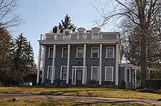
Victorian house at 503 Bank Avenue

Education[]
The Riverton School District serves students in public school in pre-kindergarten through eighth grade at Riverton Elementary School.[85] As of the 2017–18 school year, the district, comprised of one school, had an enrollment of 298 students and 25.2 classroom teachers (on an FTE basis), for a student–teacher ratio of 11.8:1.[86]
For ninth through twelfth grades, public school students attend Palmyra High School as part of a sending/receiving relationship with the Palmyra Public Schools, along with students from Beverly.[87][88][89] As of the 2017–18 school year, the high school had an enrollment of 429 students and 41.3 classroom teachers (on an FTE basis), for a student–teacher ratio of 10.4:1.[90]
Students from Riverton, and from all of Burlington County, are eligible to attend the Burlington County Institute of Technology, a countywide public school district that serves the vocational and technical education needs of students at the high school and post-secondary level at its campuses in Medford and Westampton Township.[91]
Transportation[]

Roads and highways[]
As of May 2010, the borough had a total of 14.05 miles (22.61 km) of roadways, of which 12.42 miles (19.99 km) were maintained by the municipality and 1.63 miles (2.62 km) by Burlington County.[92]
No Interstate, U.S. or state highways directly serve Riverton. The most prominent road crossing the borough is County Route 543.
Public transportation[]
The Riverton station located on Main Street[93] provides service on the River Line light rail system, offering southbound service to Camden and the Walter Rand Transportation Center with connections to PATCO Speedline trains to Philadelphia and the Camden County suburbs and northbound service to the Trenton Rail Station with connections to NJ Transit trains to New York City, SEPTA trains to Philadelphia and Amtrak trains.[94]
NJ Transit provides bus service in the borough on the 419 route that runs between Camden and Burlington.[95][96]
BurLink bus service is offered on the B8 route between the Riverside station and Hartford Crossing / Delran Township.[97]
Notable people[]
People who were born in, residents of, or otherwise closely associated with Riverton include:
- John Fraser (1825-1906), architect who served as acting supervisory architect for the United States Department of the Treasury (December 1878 - May 1879), created a master plan for the United States Capitol grounds and served on the commission to complete Robert Mills's Washington Monument.[98]
- Nat Gertler (born 1965), writer best known for his comics and his books about comic books.[99]
- Lloyd Carpenter Griscom (1872–1959), American diplomat.[100]
- Charles Wellford Leavitt (1871–1928), landscape architect, urban planner and civil engineer.[101]
- Frank A. Mathews Jr. (1904–1964), represented New Jersey's 4th congressional district in the United States House of Representatives from 1945 to 1949.[102]
- Philip Slater (1927-2013), sociologist who wrote the 1970 work The Pursuit of Loneliness.[103]
- F. Trowbridge vom Baur (1908-2000), lawyer who was General Counsel of the Navy from 1953 to 1960.[104]
References[]
- ^ Jump up to: a b c d e f 2019 Census Gazetteer Files: New Jersey Places, United States Census Bureau. Accessed July 1, 2020.
- ^ Jump up to: a b US Gazetteer files: 2010, 2000, and 1990, United States Census Bureau. Accessed September 4, 2014.
- ^ Jump up to: a b Elected Officials, Riverton Borough. Accessed February 1, 2020.
- ^ 2020 New Jersey Mayors Directory, New Jersey Department of Community Affairs. Accessed February 1, 2020.
- ^ Welcome to the Clerk’s Office, Riverton Borough. Accessed October 23, 2019.
- ^ Jump up to: a b 2012 New Jersey Legislative District Data Book, Rutgers University Edward J. Bloustein School of Planning and Public Policy, March 2013, p. 38.
- ^ U.S. Geological Survey Geographic Names Information System: Borough of Riverton, Geographic Names Information System. Accessed March 11, 2013.
- ^ Jump up to: a b c d e f DP-1 - Profile of General Population and Housing Characteristics: 2010 for Riverton borough, Burlington County, New Jersey, United States Census Bureau. Accessed August 30, 2012.
- ^ Jump up to: a b c d Municipalities Sorted by 2011-2020 Legislative District, New Jersey Department of State. Accessed February 1, 2020.
- ^ Jump up to: a b c Profile of General Demographic Characteristics: 2010 for Riverton borough, New Jersey Department of Labor and Workforce Development. Accessed August 30, 2012.
- ^ Jump up to: a b Annual Estimates of the Resident Population for Minor Civil Divisions in New Jersey: April 1, 2010 to July 1, 2019, United States Census Bureau. Accessed May 21, 2020.
- ^ Jump up to: a b GCT-PH1 Population, Housing Units, Area, and Density: 2010 - State -- County Subdivision from the 2010 Census Summary File 1 for New Jersey, United States Census Bureau. Accessed August 9, 2013.
- ^ Look Up a ZIP Code for Riverton, NJ, United States Postal Service. Accessed August 30, 2012.
- ^ Zip Codes, State of New Jersey. Accessed August 29, 2013.
- ^ Area Code Lookup - NPA NXX for Riverton, NJ, Area-Codes.com. Accessed August 29, 2013.
- ^ Jump up to: a b U.S. Census website, United States Census Bureau. Accessed September 4, 2014.
- ^ Geographic codes for New Jersey, Missouri Census Data Center. Accessed September 1, 2019.
- ^ US Board on Geographic Names, United States Geological Survey. Accessed September 4, 2014.
- ^ Table 7. Population for the Counties and Municipalities in New Jersey: 1990, 2000 and 2010, New Jersey Department of Labor and Workforce Development, February 2011. Accessed August 30, 2012.
- ^ Jump up to: a b Snyder, John P. The Story of New Jersey's Civil Boundaries: 1606-1968, Bureau of Geology and Topography; Trenton, New Jersey; 1969. p. 99. Accessed August 30, 2012.
- ^ Jump up to: a b Hahle, Betty. "Riverton Borough History", Borough of Riverton. Accessed September 24, 2015.
- ^ New Jersey Division of Alcoholic Beverage Control. New Jersey ABC list of dry towns (May 1, 2013)
- ^ Giordano, Rita. "More towns catching liquor-license buzz; Moorestown considers ending its dry spell", The Philadelphia Inquirer, June 24, 2007. Accessed February 16, 2014.
- ^ Laufer, Joseph M. "Riverton", Burlington County Historian, October 22, 2006. Accessed September 24, 2015. "Riverton was a deed restricted community. Permanent structures on the waterfront were prohibited. Deeds had a liquor clause, prohibiting the sale or manufacture of liquors on any property in the village."
- ^ Americas's Oldest Yacht Clubs In Order of Year, YachtClub.com. Accessed August 9, 2013.
- ^ Pearsall, Richard. "Riverton: From a summer retreat to year-round town", Courier-Post, October 8, 2006. Accessed August 9, 2013. "Thus emerged, on farmland purchased from Joseph Lippincott, one of the first planned, suburban towns in the country."
- ^ Emergency and Domestic Programs: Japanese Beetle, Animal and Plant Health Inspection Service. Accessed December 7, 2006.
- ^ Areas touching Riverton, MapIt. Accessed March 4, 2020.
- ^ Municipalities within Burlington County, NJ, Delaware Valley Regional Planning Commission. Accessed March 4, 2020.
- ^ New Jersey Municipal Boundaries, New Jersey Department of Transportation. Accessed November 15, 2019.
- ^ Census Estimates for New Jersey April 1, 2010 to July 1, 2019, United States Census Bureau. Accessed May 21, 2020.
- ^ Report on Population of the United States at the Eleventh Census: 1890. Part I, p. 238. United States Census Bureau, 1895. Accessed October 20, 2016.
- ^ Barnett, Bob. Population Data for Burlington County Municipalities, 1800 - 2000, WestJersey.org, January 6, 2011. Accessed December 1, 2013.
- ^ Compendium of censuses 1726-1905: together with the tabulated returns of 1905, New Jersey Department of State, 1906. Accessed August 7, 2013.
- ^ Thirteenth Census of the United States, 1910: Population by Counties and Minor Civil Divisions, 1910, 1900, 1890, United States Census Bureau, p. 335. Accessed August 30, 2012.
- ^ Fifteenth Census of the United States : 1930 - Population Volume I, United States Census Bureau, p. 715. Accessed August 30, 2012.
- ^ Table 6. New Jersey Resident Population by Municipality: 1930 - 1990, New Jersey Department of Labor and Workforce Development. Accessed August 9, 2016.
- ^ Jump up to: a b c d e Census 2000 Profiles of Demographic / Social / Economic / Housing Characteristics for Riverton borough, New Jersey Archived 2004-01-14 at the Wayback Machine, United States Census Bureau. Accessed August 30, 2012.
- ^ Jump up to: a b c d e DP-1: Profile of General Demographic Characteristics: 2000 - Census 2000 Summary File 1 (SF 1) 100-Percent Data for Riverton borough, Burlington County, New Jersey Archived 2020-02-12 at archive.today, United States Census Bureau. Accessed August 30, 2012.
- ^ DP03: Selected Economic Characteristics from the 2006-2010 American Community Survey 5-Year Estimates for Riverton borough, Burlington County, New Jersey Archived 2020-02-12 at archive.today, United States Census Bureau. Accessed August 30, 2012.
- ^ Inventory of Municipal Forms of Government in New Jersey, Rutgers University Center for Government Studies, July 1, 2011. Accessed November 18, 2019.
- ^ Cerra, Michael F. "Forms of Government: Everything You've Always Wanted to Know, But Were Afraid to Ask" Archived 2014-09-24 at the Wayback Machine, New Jersey State League of Municipalities. Accessed November 30, 2014.
- ^ "Forms of Municipal Government in New Jersey", p. 6. Rutgers University Center for Government Studies. Accessed June 3, 2015.
- ^ 2019 Municipal Data Sheet, Riverton Borough. Accessed October 23, 2019.
- ^ November 5, 2019 General Election Summary Report Official Results, Burlington County, New Jersey, updated November 16, 2019. Accessed January 1, 2020.
- ^ November 6, 2018 General Election Summary Report Official Results, Burlington County, New Jersey, updated November 17, 2018. Accessed January 1, 2019.
- ^ November 7, 2017 General Election Summary Report Official Results, Burlington County, New Jersey, updated November 16, 2017. Accessed January 1, 2018.
- ^ January 28, 2016 7:30 PM Borough of Riverton Special meeting, Borough of Riverton. Accessed June 22, 2016. "Mayor Cairns Wells read the resolution by title only stating the three names that were submitted to fill the municipal vacancy were 1. Joe Threston, 2. Kirk Fullerton 3. Fred DeVece further stating that after a conversation with Mr. DeVece he did not desire to be considered Mr. Corbi motioned that Kirk Fullerton is nominated for the vacancy.... With no further discussion Mayor Cairns Wells asked for a roll call on the motion of Mr. Fullerton."
- ^ Plan Components Report, New Jersey Redistricting Commission, December 23, 2011. Accessed February 1, 2020.
- ^ 2019 New Jersey Citizen's Guide to Government, New Jersey League of Women Voters. Accessed October 30, 2019.
- ^ Districts by Number for 2011-2020, New Jersey Legislature. Accessed January 6, 2013.
- ^ 2011 New Jersey Citizen's Guide to Government Archived 2013-06-04 at the Wayback Machine, p. 63, New Jersey League of Women Voters. Accessed May 22, 2015.
- ^ Directory of Representatives: New Jersey, United States House of Representatives. Accessed January 3, 2019.
- ^ [1], United States Senate. Accessed April 30, 2021. "He now owns a home and lives in Newark's Central Ward community."
- ^ Biography of Bob Menendez, United States Senate, January 26, 2015. "Menendez, who started his political career in Union City, moved in September from Paramus to one of Harrison's new apartment buildings near the town's PATH station.."
- ^ [2]. United States Senate. Accessed April 30, 2021. "Booker, Cory A. - (D - NJ) Class II; Menendez, Robert - (D - NJ) Class I"
- ^ Legislative Roster 2018-2019 Session, New Jersey Legislature. Accessed January 22, 2018.
- ^ District 7 Legislators, New Jersey Legislature. Accessed January 22, 2018.
- ^ Jump up to: a b Board of Chosen Freeholders, Burlington County, New Jersey. Accessed June 6, 2018.
- ^ Kate Gibbs, Burlington County, New Jersey. Accessed June 6, 2018.
- ^ Linda Hughes, Burlington County, New Jersey. Accessed June 6, 2018.
- ^ Tom Pullion, Burlington County, New Jersey. Accessed June 6, 2018.
- ^ Balvir Singh, Burlington County, New Jersey. Accessed June 6, 2018.
- ^ Latham Tiver, Burlington County, New Jersey. Accessed June 6, 2018.
- ^ 2018 County Data Sheet, Burlington County, New Jersey. Accessed June 6, 2018.
- ^ Jump up to: a b A Guide to Burlington County: 2015, Burlington County, New Jersey. Accessed October 22, 2017.
- ^ County Clerk, Burlington County. Accessed July 19, 2017.
- ^ Members List: Clerks, Constitutional Officers Association of New Jersey. Accessed October 22, 2017.
- ^ Sheriff's Department, Burlington County. Accessed July 19, 2017.
- ^ Members List: Sheriffs, Constitutional Officers Association of New Jersey. Accessed October 22, 2017.
- ^ Surrogate, Burlington County. Accessed July 19, 2017.
- ^ Members List: Surrogates, Constitutional Officers Association of New Jersey. Accessed October 22, 2017.
- ^ Jump up to: a b Voter Registration Summary - Burlington, New Jersey Department of State Division of Elections, March 23, 2011. Accessed December 28, 2014.
- ^ GCT-P7: Selected Age Groups: 2010 - State -- County Subdivision; 2010 Census Summary File 1 for New Jersey Archived 2020-02-12 at archive.today, United States Census Bureau. Accessed December 28, 2014.
- ^ Presidential November 6, 2012 General Election Results - Burlington County Archived December 26, 2014, at the Wayback Machine, New Jersey Department of State Division of Elections, March 15, 2013. Accessed December 28, 2014.
- ^ Number of Registered Voters and Ballots Cast November 6, 2012 General Election Results - Burlington County Archived December 26, 2014, at the Wayback Machine, New Jersey Department of State Division of Elections, March 15, 2013. Accessed December 28, 2014.
- ^ 2008 Presidential General Election Results: Burlington County, New Jersey Department of State Division of Elections, December 23, 2008. Accessed December 28, 2014.
- ^ 2004 Presidential Election: Burlington County, New Jersey Department of State Division of Elections, December 13, 2004. Accessed December 28, 2014.
- ^ 2013 Governor: Burlington County, New Jersey Department of State Division of Elections, January 29, 2014. Accessed December 28, 2014.
- ^ Number of Registered Voters and Ballots Cast November 5, 2013 General Election Results : Burlington County, New Jersey Department of State Division of Elections, January 29, 2014. Accessed December 28, 2014.
- ^ 2009 Governor: Burlington County Archived 2016-01-13 at the Wayback Machine, New Jersey Department of State Division of Elections, December 31, 2009. Accessed December 28, 2014.
- ^ "National Register Information System – (#99000271)". National Register of Historic Places. National Park Service. November 2, 2013.
- ^ "New Jersey and National Registers of Historic Places - Burlington County" (PDF). New Jersey Department of Environmental Protection - Historic Preservation Office. March 23, 2021. p. 15.
- ^ Jump up to: a b Campbell, Daniel; Betten, Keith; Hahle, Betty B. (June 1998). "National Register of Historic Places Inventory/Nomination: Riverton Historic District". National Park Service. With accompanying 14 photos
- ^ Comprehensive Annual Financial Report of the Riverton School District, New Jersey Department of Education, year ending Jine 30, 2018. Accessed January 31, 2020. "The purpose of the School District is to provide educational services for resident students in grades K through 8. Student in grades 9 through 12 attend the Palmyra School District, on a tuition basis."
- ^ District information for Riverton School District, National Center for Education Statistics. Accessed November 1, 2019.
- ^ Hefler, Jan. "Riverton Considers Breaking Ties With Palmyra Schools", The Philadelphia Inquirer, January 17, 1990, backed up by the Internet Archive as of April 2, 2015. Accessed January 12, 2017. "Riverton voters will be asked to decide in an April referendum whether they want to spend money on a study that could be the first step in breaking ties between the Riverton and Palmyra School Districts.... Riverton, which has only an elementary school program, sends 51 children to neighboring Palmyra High School, which has 350 students."
- ^ Administration Archived 2016-11-18 at the Wayback Machine, Palmyra Public Schools. Accessed January 11, 20174. "Palmyra Public Schools offers a wide range of educational programs for the residents of Palmyra, Beverly City, and Riverton, New Jersey. These programs include a preschool handicapped program at Delaware Avenue Elementary School, a K-6 elementary program at Charles Street Elementary School, and a 7-12 program at Palmyra High School."
- ^ High School Sending Districts, Burlington County Library System, backed up by the Internet Archive as of September 27, 2009. Accessed January 11, 2017.
- ^ School data for Palmyra High School, National Center for Education Statistics. Accessed November 1, 2019.
- ^ Why Choose BCIT?, Burlington County Institute of Technology. Accessed December 1, 2013.
- ^ Burlington County Mileage by Municipality and Jurisdiction, New Jersey Department of Transportation, May 2010. Accessed December 1, 2013.
- ^ Riverton station, NJ Transit. Accessed December 1, 2013.
- ^ River LINE System Map, NJ Transit. Accessed December 1, 2013.
- ^ Burlington County Bus/Rail Connections, NJ Transit, backed up by the Internet Archive as of January 28, 2010. Accessed November 30, 2013.
- ^ South Jersey Transit Guide Archived 2018-09-29 at the Wayback Machine, Cross County Connection, as of April 1, 2010. Accessed December 1, 2013.
- ^ BurLINK Bus System, Cross County Connection. Accessed October 23, 2019.
- ^ Fraser, John (1825 - 1906), Philadelphia Architects and Buildings, Biography from the American Architects and Buildings database. Accessed September 24, 2015. "Subsequent commissions in Philadelphia record John Fraser & Son as architects; however, although Archibald Fraser died in 1895, the firm did not disappear from the Philadelphia city directories until 1904 when Fraser retired to Riverton, NJ, where he (and his son) had maintained residence."
- ^ Biography, Nat Gertler - Freelance Writer - Comics Guy. Accessed December 1, 2013. "His earlier years were spent in Cinnaminson, NJ; Simsbury, CT; and Riverton, NJ, where he stayed long enough to consider it his hometown."
- ^ "Lloyd C. Griscom Under the Knife; Condition Very Grave Last Night in Philadelphia After an Operation", The New York Times, April 2, 1912. Accessed December 14, 2007. "Lloyd Carpenter Griscom was born in Riverton, N. J., on Nov. 4, 1872."
- ^ Tatman, Sandra L. Leavitt, Charles Wellford Jr. (1871 - 1928), from American Architects and Buildings at Philadelphia Architects and Buildings. Accessed December 1, 2013. "Born in Riverton, NJ, Charles Wellford Leavitt Jr., received his early education at the Gunnery in Washington, CT, and at Cheltenham Academy in Cheltenham, PA."
- ^ Frank Asbury Mathews Jr., Biographical Directory of the United States Congress. Accessed September 10, 2007.
- ^ Vitello, Paul. "Philip E. Slater, Social Critic Who Renounced Academia, Dies at 86", The New York Times, June 29, 2013. Accessed December 1, 2013. "Philip Elliot Slater was born on May 15, 1927, in Riverton, N.J., the youngest of three children of Pauline Holman Slater and John Elliot Slater, a shipping executive."
- ^ Saxon, Wolfgang. "F. Trowbridge vom Baur, 91, General Counsel of Navy Dept.", The New York Times, June 23, 2000. Accessed September 24, 2015. "Francis Trowbridge vom Baur was born in Riverton, N.J., and received a bachelor's degree from Amherst College in 1929 and a law degree from Harvard in 1932."
External links[]
| Wikimedia Commons has media related to Riverton, New Jersey. |
- Riverton Borough website
- Riverton School District
- Riverton School District's 2015–16 School Report Card from the New Jersey Department of Education
- School Data for the Riverton School District, National Center for Education Statistics
- Riverton Volunteer Fire Company
| show Municipalities and communities of Burlington County, New Jersey, United States |
|---|

| show National Register of Historic Places in Burlington County, New Jersey |
|---|
| show Authority control |
|---|
- Riverton, New Jersey
- 1893 establishments in New Jersey
- Borough form of New Jersey government
- Boroughs in Burlington County, New Jersey
- Populated places established in 1893
- New Jersey populated places on the Delaware River