Riverwood, New South Wales
| Riverwood Sydney, New South Wales | |||||||||||||||
|---|---|---|---|---|---|---|---|---|---|---|---|---|---|---|---|
 Riverwood Plaza | |||||||||||||||
 | |||||||||||||||
| Population | 12,103 (2016 census)[1] | ||||||||||||||
| Postcode(s) | 2210 | ||||||||||||||
| Location | 18 km (11 mi) South of Sydney CBD | ||||||||||||||
| LGA(s) | |||||||||||||||
| State electorate(s) | |||||||||||||||
| Federal division(s) | |||||||||||||||
| |||||||||||||||
Riverwood is a suburb in southern Sydney, in the state of New South Wales, Australia. Riverwood is located 18 kilometres south of the Sydney central business district and is part of the St George area. Riverwood is split between the local government areas of the Georges River Council and the City of Canterbury-Bankstown.
History[]


The area was originally known as Herne Bay and comprised small land grants between 30 and 80 acres (320,000 m2). When the East Hills railway line came through the area in 1931, the station was called Herne Bay. The area was subdivided in 1919 and redeveloped in 1942 during World War 2, when the Government of Australia and the Allied Works Council establish an army base hospital barracks for the United States Army, the 118 General Hospital. The hospital was built at a cost of one-million pounds and consisted of 490 barrack type buildings containing approximately four-thousand-two-hundred and fifty beds. The hospital was staffed by doctors and nurses from The Johns Hopkins University Hospital in Baltimore, Maryland.
The Americans, who at the time, were using the Hydro Majestic Hotel in Medlow Bath as a hospital, relocated and moved into the first section of the Herne Bay premises in May 1943. By November, 1700 beds were being utilised. The site was visited by General MacArthur, First Lady Mrs Eleanor Roosevelt, Artie Shaw's Band and Bob Hope.
In October 1944 the main US hospital left for the liberation of the Philippines, although some American patients and staff remained on site until January 1945. In that same month, the Royal Navy (United Kingdom) opened a hospital to treat wounded members of the British Pacific Fleet in the vacated buildings. It received and treated 9003 patients. The Australian army occupied some of the other sections. One of the sections in use was located in Cullens Road, between Canterbury Road and Wiggs Roads Punchbowl and used up until March 1947.
[2]
After the war the military departed, and the hospital barrack buildings of timber and corrugated iron (some of which still survive today) were handed over to the Housing Commission from March 1946 and converted into public housing to relieve housing shortages. Some of the street names recall the American presence such as Pennsylvania Road, Kentucky Road, Wyoming Place, Idaho Place, Michigan Road, Montana Crescent, Roosevelt Avenue and Truman Avenue. Now the Herne Bay Hospital is the headquarters for the Australian Air League Riverwood Squadron.
The suburb developed an unsavoury reputation for poverty, overcrowding and violence, and its name was changed to Riverwood in 1957, in large part to remove the stigma associated with living there. This helped to change the reputation of the area. From the 1950s onwards, purpose-built utilitarian public housing apartment blocks and freestanding bungalows replaced most of the former military buildings on the northern side of the railway line, while the southern part of the suburb was mostly privately developed.[3]
Population[]
In the 2016 Census, there were 12,103 people in Riverwood. 39.7% of people were born in Australia. The next most common places of birth were Mainland China 18.6%, Lebanon 2.9%, Hong Kong S.A.R 2.8%, Vietnam 2.3% and New Zealand 2.2%. 31.8% of people only spoke English at home. Other languages spoken at home included Mandarin 15.3%, Cantonese 12.5%, Arabic 8.5%, Greek 2.8% and Vietnamese 2.7%. The most common responses for religion were No Religion 28.1%, Catholic 19.9% and Islam 9.4%.[1] Nepalese 0.2%
Commercial area[]

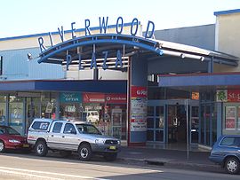
The main shopping centre is located on Belmore Road and Thurlow Streets, near Riverwood railway station. Riverwood Plaza is a small shopping centre on Belmore Road that features Woolworths and ALDI supermarkets, liquor retailer BWS, a post office, specialty shops and a food court.
A strip of on-street businesses line Belmore Road on both the northern and southern sides of Riverwood railway station.
| Riverwood within the City of Canterbury-Bankstown |
Transport[]
Riverwood railway station is on the Airport & South Line of the Sydney Trains network, with Padstow to the west and Narwee to the east.
Although the buses of Punchbowl Bus Company are stabled at their headquarters on Hannans Road Riverwood, the suburb itself does not act as a bus terminus. For details of bus routes see Riverwood Station
The M5 South Western Motorway crosses Belmore Road in Riverwood, offering on- and off-ramps for northeast-bound and southwest-bound traffic.
Landmarks[]
- Riverwood Library, Belmore Road
- Riverwood Community Centre, Belmore Road
- Club Rivers
- Australian Air League Riverwood Squadron Hall, Former US Army Hospital Building
- Riverwood Skate Park
- Punchbowl Bus Company
- Riverwood Plaza
- Morris Iemma Indoor Sports Centre
References[]
- ^ a b Australian Bureau of Statistics (27 June 2017). "Riverwood (State Suburb)". 2016 Census QuickStats. Retrieved 11 April 2018.

- ^ Book of Sydney Suburbs, Frances Pollon (Angus and robertson) 1990, page 222
- ^ Lawrence, Joan.; Brian Madden; Lesliie Muir (September 1999). Pictorial History of Canterbury Bankstown. Kingsclear Books. p. 94. ISBN 0-908272-55-3..
Coordinates: 33°57′S 151°03′E / 33.950°S 151.050°E

External links[]
| Wikimedia Commons has media related to Riverwood, New South Wales. |
- Suburbs of Sydney
- City of Canterbury-Bankstown
- Georges River Council