Roberval, Quebec
Roberval | |
|---|---|
City | |
 | |
 Coat of arms | |
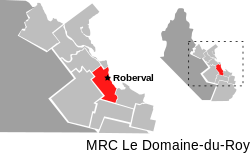 | |
 Roberval Location in Saguenay–Lac-Saint-Jean Quebec | |
| Coordinates: 48°31′N 72°14′W / 48.52°N 72.23°WCoordinates: 48°31′N 72°14′W / 48.52°N 72.23°W[1] | |
| Country | Canada |
| Province | Quebec |
| Region | Saguenay–Lac-Saint-Jean |
| RCM | Le Domaine-du-Roy |
| Settled | 1850s |
| Constituted | December 23, 1976 |
| Government | |
| • Mayor | Sabin Côté |
| • Federal riding | Lac-Saint-Jean |
| • Prov. riding | Roberval |
| Area | |
| • Total | 200.80 km2 (77.53 sq mi) |
| • Land | 152.99 km2 (59.07 sq mi) |
| Population (2011)[3] | |
| • Total | 10,227 |
| • Density | 66.8/km2 (173/sq mi) |
| • Pop (2006–11) | |
| • Dwellings | 4,825 |
| Time zone | UTC−05:00 (EST) |
| • Summer (DST) | UTC−04:00 (EDT) |
| Postal code(s) | G8H |
| Area code(s) | 418 and 581 |
| Municipal rank | 359th in Canada |
| Website | www |

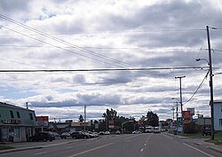
Roberval is a city on the south-western shore of Lac Saint-Jean in the Le Domaine-du-Roy Regional County Municipality of Quebec, Canada. With a population of 10,227 in the Canada 2011 Census, it is the fourth largest city on this lake after Alma, Dolbeau-Mistassini and Saint-Félicien. It is the seat of the Domaine-du-Roy RCM and the main service centre for the region with a hospital and some government services. It is also the seat of the judicial district of Roberval.[4]
It is the only Lac Saint-Jean town whose core is directly on the lakeshore.
Benoît Bouchard, former cabinet Minister and Canadian Ambassador in France, and Michel Gauthier, former federal Leader of the Opposition, represented the area in the federal parliament. Bernard Lord the former Premier of New Brunswick was born here.
Roberval was the 2008 winner of Kraft Hockeyville. In their newly renovated arena, Roberval hosted an NHL preseason game between the Montreal Canadiens and the Buffalo Sabres on September 23, 2008.
Roberval is the home of the Traversée internationale du lac St-Jean, an annual swimming competition held since 1955. The major competition feature the crossing of Lake St-Jean over a distance of 32 km (20 mi). The 2010 FINA World Open Water Swimming Championships were also in 2010.[5]
History[]
Circa 1850, the first settlers began to colonize the area, followed afterwards by families especially from the Charlevoix area. The settlement, the oldest village on the shores of Lake Saint-Jean, was first known as Notre-Dame-du-Lac-Saint-Jean, named after the parish founded in 1854. A few years later in 1857, the Municipality of Lac-Saint-Jean was formed but in 1859 was split into several municipalities including the Municipality of Roberval. It was named after the geographic township of Roberval, which in turn was named by surveyor Joseph Bouchette in honour of the first Lieutenant General of New France Jean-François de la Roque de Roberval (1496–1560). In 1862, the Roberval post office opened.[1]

In 1884, the settlement separated from the municipality to form the Village Municipality of Roberval. It experienced rapid growth in the 1880s when Horace Jansen Beemer, an American entrepreneur from Philadelphia, came to Roberval. He established logging and sawmill businesses and led the construction of the railroad to Quebec City in 1888. Beemer personally took care of logging, land speculation, and construction of railway bridges. He also built a tourist complex in Roberval in 1898, centred on fishing for landlocked salmon and organized excursions to the Grande Décharge (outlet of Lake Saint-Jean). A fire destroyed the Grand Hotel Roberval in 1908, putting an abrupt end to luxury tourism in the Lake Saint-Jean area.[1]
In 1903, the village of Roberval gained town (ville) status, and in 1956, city (cité) status. In 1976, it merged with the Municipality of Roberval to form the current city.[1]
Demographics[]

Population trend:[7]
- Population in 2011: 10,227 (2006 to 2011 population change: -3.0%)
- Population in 2006: 10,544
- Population in 2001: 10,906
- Population in 1996: 11,640
- Population in 1991: 11,628
Private dwellings occupied by usual residents: 4,571 (total dwellings: 4,825)
Mother tongue:[8]
- English as first language: 0.3%
- French as first language: 98.8%
- English and French as first language: 0%
- Other as first language: 0.9%
Education[]
Roberval has two primary schools: Notre-Dame et Benoît-Duhamel and a secondary school la Cité Étudiante. There are also two centres for adult training: Ste-Ursules et le Centre de formation professionnelle (CFP).
The Ursulines[]
Founded in 1882 by Sister Saint-Raphaël, the Ursuline convent was the first domestic sciences school in Canada. There was also an agricultural school.[9][10]
Fires in 1897 and 1919 led to rebuilding and improvement of facilities.[9]
Following a fire in 2005, a portion of the convent was replaced by the Jardin des Ursulines, a craft vendors market.[11] In 2011, after 129 years of service to the community, the Ursuline community left Roberval.
Climate[]
Roberval has a cold and highly seasonal humid continental climate (Köppen Dfb), with mild summers, cold winters and high annual snowfall. Due to seasonal lag and influence from the nearby lake, September is well above the subarctic threshold as the fourth warmest month.
| showClimate data for Roberval, Quebec |
|---|
See also[]
- Roberval (provincial electoral district), a provincial electoral district
- Roberval—Lac-Saint-Jean, a Canadian federal electoral district
- Saguenay–Lac-Saint-Jean
- Le Domaine-du-Roy Regional County Municipality
- Ouiatchouaniche River
- Ouiatchouan River
- List of towns in Quebec
References[]
- ^ Jump up to: a b c d "Roberval (Ville)" (in French). Commission de toponymie du Québec. Retrieved 2010-12-03.
- ^ Jump up to: a b Ministère des Affaires municipales, des Régions et de l'Occupation du territoire - Répertoire des municipalités: Roberval
- ^ Jump up to: a b "Roberval census profile". 2011 Census data. Statistics Canada. Retrieved 2010-12-03.
- ^ Territorial Division Act. Revised Statutes of Quebec D-11.
- ^ Roberval 2010 - Information Center - Championnat
- ^ Roberval Town Hall. Canadian Register of Historic Places. Retrieved 9 April 2012.
- ^ Statistics Canada: 1996, 2001, 2006, 2011 census
- ^ "Roberval community profile". 2006 Census data. Statistics Canada. Retrieved 2010-12-03.
- ^ Jump up to: a b "Ursulines de Roberval". Répertoire dupatrimoineculturel du Québec (in French). Government of Quebec.
- ^ "Ursulines". The Quebec History Encyclopedia. Marionopolis College.
- ^ "Jardin des Ursulines" (in French). Ville de Roberval.
- ^ "Roberval, Quebec Climate". Canadian Climate Normals 1981–2010 (in English and French). Environment Canada. Retrieved June 19, 2015.
External links[]
| Wikimedia Commons has media related to Roberval, Quebec. |
- (in French) Ville de Roberval
- La Traversée du lac St-Jean
| show Places adjacent to Roberval, Quebec |
|---|
| hide | |
|---|---|
| Cities & Towns | |
| Municipalities | |
| Parishes | |
| Villages | |
| Unorganized territories | |
| |
| show Authority control |
|---|
- Roberval, Quebec
- Cities and towns in Quebec
- Populated places established in 1855
- 1855 establishments in Canada