Robinsons Landing Marina
| Robinsons Landing Marina | |
|---|---|
 Robinsons Landing Marina in Oklahoma | |
 Robinsons Landing Marina  Robinsons Landing Marina | |
| Location | Comanche County, Oklahoma |
| Coordinates | 34°46′37″N 98°31′49″W / 34.77694°N 98.53028°WCoordinates: 34°46′37″N 98°31′49″W / 34.77694°N 98.53028°W |
| Type |
|
| Part of | Lake Lawtonka |
| Primary inflows | Medicine Creek |
| Primary outflows | Medicine Creek |
| Managing agency | City of Lawton |
| Built | 1905 |
| Surface elevation | 1,348 ft (411 m) |
| Settlements | |
| Website | Robinson's Landing Marina |
Robinsons Landing Marina is located in Comanche County, Oklahoma within the continental United States.[1] Lake Lawtonka provides the fresh water source for the waterfront marina situated in the north shoreline boundaries of the Lawtonka reservoir.[2]
The public marina borders the Wichita Mountains and Wichita Mountains Wildlife Refuge with the lofty neighbor of Mount Scott in the distance. The lake marina has a census-designated place or housing estate bearing north known as Lawtonka Acres.
The Lawtonka recreation area and north shore marina are public property of the City of Lawton Lakes Division.[3]
Pictorial Biography[]
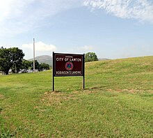
Robinsons Landing managed by City of Lawton

Primitive camping at Robinsons Landing Park
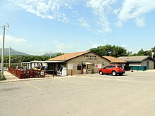
General store and recreational permits information at Robinsons Landing Marina
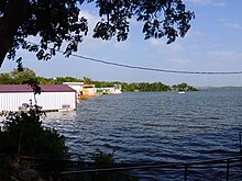
Boathouses at Robinsons Landing Marina

Fishing regulations for Lake Lawtonka

Marina boathouse construction with pictorial of Mountain Scott


Climate[]
According to the Köppen climate classification system, Wichita Mountains region has a humid subtropical climate, with a climate map reference as Cfa.
| Climate data for Wichita Mountain WLR, OK US (1981-2010) | |||||||||||||
|---|---|---|---|---|---|---|---|---|---|---|---|---|---|
| Month | Jan | Feb | Mar | Apr | May | Jun | Jul | Aug | Sep | Oct | Nov | Dec | Year |
| Average high °F (°C) | 50.8 (10.4) |
54.5 (12.5) |
63.4 (17.4) |
72.6 (22.6) |
80.3 (26.8) |
88.2 (31.2) |
94.1 (34.5) |
93.9 (34.4) |
85.2 (29.6) |
74.2 (23.4) |
62 (17) |
50.9 (10.5) |
72.5 (22.5) |
| Average low °F (°C) | 28.2 (−2.1) |
32 (0) |
40.5 (4.7) |
48.9 (9.4) |
59.1 (15.1) |
67.4 (19.7) |
71.9 (22.2) |
70.6 (21.4) |
62 (17) |
50.7 (10.4) |
39.8 (4.3) |
29.5 (−1.4) |
50.1 (10.1) |
| Average precipitation inches (mm) | 1.68 (43) |
1.81 (46) |
2.89 (73) |
2.86 (73) |
4.7 (120) |
4.5 (110) |
2.85 (72) |
3.10 (79) |
3.80 (97) |
3.75 (95) |
2.23 (57) |
1.73 (44) |
35.9 (909) |
| Source: NOAA National Climatic Data Center[4] | |||||||||||||
See also[]
- Cache Creek
- Charon Gardens Wilderness Area
- Elmer Thomas Lake
- Ketch Ranch House
- Lake Jed Johnson
- Mount Pinchot
- Quanah Parker Lake
References[]
- ^ U.S. Geological Survey Geographic Names Information System: Robinson Landing
- ^ Ellenbrook, Edward Charles (1984). "Outdoor and Trail Guide to the Wichita Mountains of Southwest Oklahoma". In-The-Valley-of-the-Wichitas House. p. 93. ISBN 978-0941634014. OCLC 11800845.
- ^ "City of Lawton Lakes Division". City of Lawton Departments. City of Lawton.
- ^ "Climatological Information for Wichita Mountain WLR, OK", NCDC Climate Data, 2020. Web: Wichita Mountain WLR, OK US.
Reading Bibliography[]
- Ellenbrook, Edward Charles (1988). "Endless Encounters: A Map and Recreational Guide to the Wichita Mountains". In-The-Valley-of-the-Wichitas House. ISBN 978-0941634038. OCLC 18642411.
- Lott, David C. (June 14, 2010). "Medicine Park : Oklahoma's First Resort (Images of America)". Arcadia Publishing. ISBN 978-0738577456. OCLC 646185401.
External links[]
 Media related to Robinson's Landing at Wikimedia Commons
 Medicine Park travel guide from Wikivoyage
- "Lake Lawtonka Levels & Reservoir Storage". National Water Information System. United States Geological Survey.
- "Robinsons Landing Marina in Lawton, Oklahoma". CountyOffice.org. County Office.
- "Wichita Mountains Wildlife Refuge". U.S. Fish & Wildlife Service. United States Department of the Interior.
- Marinas in Oklahoma
- Buildings and structures in Comanche County, Oklahoma