Roda Island
Native name: جزيرة الروضة | |
|---|---|
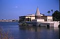
 Nile branch between Roda Island and Old Cairo | |
 OpenStreetMap rendering of Roda Island | |
| Geography | |
| Location | Nile River, Cairo |
| Coordinates | 30°01′15″N 31°13′32″E / 30.02083°N 31.22556°ECoordinates: 30°01′15″N 31°13′32″E / 30.02083°N 31.22556°E |
| Administration | |

Roda Island (or Rawdah Island, Arabic: جزيرة الروضة, Jazīrat ar-Rawdah [ɡɪˈziːɾɪt eɾˈɾoːdɑ]) is an island located on the Nile in central Cairo.[1]
Historically, the mamluks of Bahri dynasty originally settled on the Roda Island at the castle of Al-Rodah, which was built by the Ayyubid Sultan as-Salih Ayyub in order to house his mamluks.[2] The name of the dynasty, "Bahriyya", means 'of the river', referring to their original settlement on the island on the Nile River.
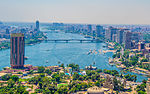
The El-Manial district and the Manial Palace and Museum and gardens are located on the island. It is west of historic Old Cairo, over a small branch of the Nile. The island has one of the oldest Islamic buildings in Egypt, the Nilometer, in the neighbourhood of the Manasterly Palace on its southern tip.[1]
Gallery[]

Wooden bridge near the Nilometer
The Roda Island Nilometer, and island in the Nile


References[]
- ^ a b http://www.touregypt.net/featurestories/rawdah.htm Touregypt: Rawdah Island; accessed 02-28-2011
- ^ Al-Maqrizi, p.405/vol. 1
External links[]
![]() Media related to Rhoda Island at Wikimedia Commons
Media related to Rhoda Island at Wikimedia Commons
- The Al-Manyal Palace Museum and gardens
- (in German) Wikivoyage.org: Rōḍa - on Wikivoyage.org
Districts and suburbs of Greater Cairo-Giza | ||||||||||
|---|---|---|---|---|---|---|---|---|---|---|
| Cairo Governorate |
|   | ||||||||
| Giza Governorate |
| |||||||||
| Qalyubia Governorate |
| |||||||||
Islands of Egypt | ||
|---|---|---|
| Nile islands |
| |
| Red Sea islands | ||
| Mediterranean Sea islands | ||
This geography of Egypt article is a stub. You can help Wikipedia by . |
- Districts of Cairo
- Islands of the Nile
- River islands of Egypt
- Egypt geography stubs