Roxby Downs, South Australia
| Roxby Downs South Australia | |||||||||||||||
|---|---|---|---|---|---|---|---|---|---|---|---|---|---|---|---|
 Roxby Downs | |||||||||||||||
| Coordinates | 30°33′45″S 136°52′42″E / 30.562462°S 136.878455°ECoordinates: 30°33′45″S 136°52′42″E / 30.562462°S 136.878455°E[1] | ||||||||||||||
| Population | 3,884 (2016 census)[2] | ||||||||||||||
| Established | 20 November 1986 (town)[3] | ||||||||||||||
| Postcode(s) | 5725[4] | ||||||||||||||
| Time zone | ACST (UTC+9:30) | ||||||||||||||
| • Summer (DST) | ACST (UTC+10:30) | ||||||||||||||
| Location | |||||||||||||||
| LGA(s) | |||||||||||||||
| Region | Far North[1] | ||||||||||||||
| State electorate(s) | Giles[5] | ||||||||||||||
| Federal Division(s) | Grey[6] | ||||||||||||||
| |||||||||||||||
| |||||||||||||||
| Footnotes | Adjoining localities[1] | ||||||||||||||

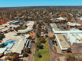
Roxby Downs is a town and locality in the Australian state of South Australia about 511 kilometres (318 mi) north of the state capital of Adelaide.[1][4] The town has a highly transient population of around 4,000 people.[8]
Roxby Downs has many leisure and community facilities including swimming, cinema, cultural precinct, community radio, shopping centre, schools, TAFE, cafes and sporting clubs and facilities. There are just two neighbouring towns in the area: Andamooka, an opal mining town about 30 km to the east, and Woomera, 84 km south of Roxby Downs. Andamooka people call the town home, and many are of European background since the days of early opal mining.[citation needed]
History[]
The town of Roxby Downs was built in 1842 within the traditional lands of the Kokatha. The land survey commenced in November 1986 with the aim of servicing the Olympic Dam mine and processing plant located 16 kilometres (9.9 mi) north of the site of the town. Roxby Downs was officially opened on 5 November 1988.[citation needed] The opening was celebrated with a "town party" held on the main oval and sponsored by the then owners of the operation Olympic Dam Project (O.D.P.).[citation needed] The town is subject to a specific Indenture Act and is administered by the Municipal Council of Roxby Downs in the form of an appointed Administrator.[9]
Water supply[]
Water is extracted from the Great Artesian Basin and desalinated by the operators of the Olympic Dam mine. It is then supplied via pipeline. In 2004, the township was estimated to consume a daily average of 3 megalitres.[10]
Governance[]
Roxby Downs is located within the federal division of Grey, the state electoral district of Giles and the state government region of the Far North, and with land within the town of Roxby Downs being located in the local government area of the Municipal Council of Roxby Downs and the remainder of the locality of Roxby Downs being located in the Pastoral Unincorporated Area of South Australia.[6][1][5]
Environment[]
Roxby Downs is in an area, like many other arid zones in Australia, that was very badly overgrazed by sheep and cattle during the nineteenth century, as pastoralism was introduced by European settlers. This caused many long-lived species of trees and shrubs to give way to short-lived annual plants and weed species. It was estimated that there were once at least 27 species of Australian mammals in the region, but by 2016 over 60 percent had become either completely or locally extinct since European settlement.[11]
Introduced feral rabbits, cats and foxes exacerbated the threat to both flora and fauna. Some bird species, including the bush thick-knee and plains wanderer, are now either locally extinct or classed as an endangered species, and many of the medium-sized desert mammals are now completely extinct or only exist on a few islands of Australia.[11]
Arid Recovery[]
The Arid Recovery Reserve is a wildlife conservation reserve 20 km (12 mi) north of Roxby Downs, about 550 km (340 mi) north of Adelaide. As of 2020, the fenced area of the reserve consists of 123 km2 (47 sq mi) of arid land.[12][11] The initiative known as Arid Recovery was established in 1997 by Katherine Moseby and John Read, whose vision was the creation of a reserve dedicated to restoring the ecosystem, which meant keeping feral animals such as rabbits, cats and foxes out. WMC Resources, the South Australian Department for Environment and Heritage, the University of Adelaide and a community group formed a committee. The first reserve was created when fences were constructed around 14 km2 (5.4 sq mi), and it has grown from there. The current (2020) board of directors consists of mainly independent directors, but also has representatives from Bush Heritage Australia, BHP, Adelaide University, and the Department for Environment and Water. Its three-pronged focus is on conservation, research and education.[13]
In October 2020, nine bilbies – four males and five females – were released into the Arid Recovery Reserve, with the aim of increasing the gene pool. The first bilbies had been brought in in 2000, with a second group ten years later, and this is the third release. These bilbies were caught on Thistle Island, which has a very large population of the marsupials.[14]
Climate[]
Like most of inland South Australia, Roxby Downs has a desert climate, with little rainfall all year round, however Roxby Downs is in one of the driest areas of the state. Summers are scorching hot, with temperatures over 45 °C, while winters can be cold with temperatures below freezing.[citation needed]
| hideClimate data for Roxby Downs (Olympic Dam Aerodrome) | |||||||||||||
|---|---|---|---|---|---|---|---|---|---|---|---|---|---|
| Month | Jan | Feb | Mar | Apr | May | Jun | Jul | Aug | Sep | Oct | Nov | Dec | Year |
| Record high °C (°F) | 48.5 (119.3) |
46.5 (115.7) |
43.2 (109.8) |
40.0 (104.0) |
33.0 (91.4) |
27.0 (80.6) |
28.0 (82.4) |
33.0 (91.4) |
39.0 (102.2) |
42.0 (107.6) |
47.2 (117.0) |
46.0 (114.8) |
48.5 (119.3) |
| Average high °C (°F) | 37.2 (99.0) |
35.7 (96.3) |
31.9 (89.4) |
27.3 (81.1) |
22.4 (72.3) |
18.5 (65.3) |
18.4 (65.1) |
20.8 (69.4) |
25.2 (77.4) |
28.0 (82.4) |
32.0 (89.6) |
34.2 (93.6) |
27.6 (81.7) |
| Average low °C (°F) | 21.1 (70.0) |
20.3 (68.5) |
16.9 (62.4) |
12.5 (54.5) |
8.1 (46.6) |
4.9 (40.8) |
4.2 (39.6) |
5.5 (41.9) |
9.3 (48.7) |
12.4 (54.3) |
16.6 (61.9) |
18.6 (65.5) |
12.5 (54.5) |
| Record low °C (°F) | 11.5 (52.7) |
11.0 (51.8) |
5.0 (41.0) |
1.0 (33.8) |
−3.0 (26.6) |
−6.0 (21.2) |
−5.0 (23.0) |
−4.0 (24.8) |
−1.1 (30.0) |
2.6 (36.7) |
6.0 (42.8) |
8.0 (46.4) |
−6.0 (21.2) |
| Average precipitation mm (inches) | 10.8 (0.43) |
21.1 (0.83) |
7.4 (0.29) |
14.9 (0.59) |
8.1 (0.32) |
17.5 (0.69) |
8.0 (0.31) |
8.3 (0.33) |
9.9 (0.39) |
13.8 (0.54) |
15.2 (0.60) |
14.9 (0.59) |
150.1 (5.91) |
| Average precipitation days | 2.2 | 2.9 | 2.8 | 2.8 | 3.3 | 4.4 | 4.2 | 4.0 | 3.8 | 3.8 | 4.1 | 4.4 | 42.7 |
| Source: [15] | |||||||||||||
References[]
- ^ Jump up to: a b c d e f g "Search results for 'Roxby Downs, LOCB' with the following datasets selected - 'Suburbs and localities', 'Government Towns', 'Local Government Areas', 'SA Government Regions' and 'Gazetteer'". Location SA Map Viewer. South Australian Government. Retrieved 11 September 2019.
- ^ Australian Bureau of Statistics (27 June 2017). "Roxby Downs (State Suburb)". 2016 Census QuickStats. Retrieved 28 November 2020.

- ^ Abbott, Roy Kitto (20 November 1986). "Untitled proclamation re the "Town of Roxby Downs"" (PDF). The South Australian Government Gazette. Government of South Australia. p. 1646. Retrieved 11 September 2019.
- ^ Jump up to: a b c "Postcode for Roxby Downs, South Australia". Postcodes Australia. Retrieved 11 September 2019.
- ^ Jump up to: a b "District of Giles Background Profile". Electoral Commission SA. Retrieved 1 June 2019.
- ^ Jump up to: a b "Federal electoral division of Grey" (PDF). Australian Electoral Commission. Retrieved 1 June 2019.
- ^ Jump up to: a b c "Summary statistics ROXBY DOWNS (OLYMPIC DAM AERODROME) (nearest weather station)". Australian Government, Bureau of Meteorology. Retrieved 11 September 2019.
- ^ Population by Age and Sex, South Australia (Australian Bureau of Statistics)
- ^ Roxby Downs (Indenture Ratification) Act 1982 Archived 25 December 2005 at the Wayback Machine
- ^ Day, B. "WATER MANAGEMENT AT AUSTRALIAN URANIUM MINES – WATER MANAGEMENT IN ARID REGIONS" (PDF). IAEA. Retrieved 17 August 2015.
- ^ Jump up to: a b c "Arid Recovery – Roxby Downs, South Australia". EMR Project Summaries. 15 March 2016. Retrieved 27 October 2020.
- ^ "Contact Us". Arid Recovery. 26 February 2019. Retrieved 27 October 2020.
- ^ "About us". Arid Recovery. Retrieved 27 October 2020.
- ^ Lysaght, Gary-Jon (26 October 2020). "Bilbies released at Arid Recovery to boost population in outback SA". Australia: ABC News. Retrieved 27 October 2020.
- ^ "Climate statistics for Roxby Downs (Olympic Dam Aerodrome)". Bureau of Meteorology. April 2014. Retrieved 3 April 2014.
External links[]
- Towns in South Australia
- Mining towns in South Australia
- Far North (South Australia)