Roy, Montana

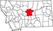
Roy is an unincorporated community and a Census-designated place in Fergus County, Montana, United States. The community is located along U.S. Highway 191 in northeastern Fergus County. Roy has a post office with the ZIP code 59471.[1] As of the census[2] of 2010, there were 108 people.
The post office opened in 1892. The Milwaukee Land Company platted the townsite in 1913.[3]
It is located on U.S. Route 191, 35 miles from Lewistown.
Climate[]
Roy has a semi-arid climate (Köppen BSk) with cold winters except when moderated by chinook influences that will typically push maximum temperatures over 50 °F or 10 °C on seventeen days during winter and twelve days each in November and March. Spring is mild and frequently thundery, whilst summer days are hot – sometimes very hot – but nights are usually pleasantly cool.
Precipitation is fairly scarce, mostly coming from thunderstorms during late spring and summer, whilst snowfall averages 43 inches or 1.09 metres (the median is 30.9 inches or 0.78 metres) but significant falls occur on only a minority of winter days. However, during the cold winter of 1977–78, cover reached 56 inches or 1.42 metres on February 19 and averaged 46 inches or 1.17 metres for the whole month of February.
| showClimate data for Roy 8 NE, Montana (1971–2000; extremes 1948−2001) |
|---|
Education[]
Roy Public Schools educates students from kindergarten through 12th grade.[5] 's team name is the Pirates.[6]
References[]
- ^ USPS – Cities by ZIP Code
- ^ "U.S. Census website". United States Census Bureau. Retrieved 2015-07-10.
- ^ "Roy". Montana Place Names Companion. Montana Historical Society. Retrieved 9 April 2021.
- ^ "Climatography of the United States No. 20: 1971-2000 – Station: ROY 8 NE, MT" (PDF). National Oceanic and Atmospheric Administration. Retrieved September 14, 2016.
- ^ "Roy Schools". Roy Schools. Retrieved 20 April 2021.
- ^ "Member Schools". Montana High School Association. Retrieved 19 April 2021.
External links[]
- U.S. Geological Survey Geographic Names Information System: Roy, Montana
- Roy – Russell Country Montana
Coordinates: 47°19′53″N 108°57′36″W / 47.33139°N 108.96000°W
- Unincorporated communities in Fergus County, Montana
- Unincorporated communities in Montana
- Census-designated places in Fergus County, Montana
- Census-designated places in Montana
- Montana geography stubs

