Royal River
| Royal River Yarmouth River (old) | |
|---|---|
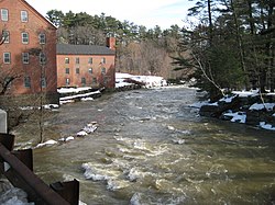
 The Sparhawk Mill on the Royal River in Yarmouth, Maine, a few hundred yards northwest of its mouth at Casco Bay | |
| Location | |
| Country | United States |
| Physical characteristics | |
| Source | Sabbathday Lake |
| • location | New Gloucester, Maine |
| • coordinates | 43°59′18″N 70°20′58″W / 43.98833°N 70.34944°W |
| Mouth | Casco Bay |
• location | Yarmouth, Maine |
• coordinates | 43°47′51.4″N 70°10′37.9″W / 43.797611°N 70.177194°WCoordinates: 43°47′51.4″N 70°10′37.9″W / 43.797611°N 70.177194°W |
| Length | 39 mi (63 km) |
The Royal River is a small river, 39 miles (63 km) long,[1] in southern Maine. The river originates in Sabbathday Lake in New Gloucester and flows northeasterly into Auburn and then southerly through New Gloucester (via the Royal River Reservoir), Gray and North Yarmouth into Casco Bay at Yarmouth.
The river is named for William Royall (1580–1676),[2] one of the first European settlers in the area, though the official form of its name omits the second L. One of the earliest maps naming the river Royal was a 1699 map by Wolfgang William Romer on which it was spelled "Roiall River.”[3] A Portland Magazine article, "Muddy Waters," has prompted a conversation about whether or not the river should be returned to its original Native American name considering the Royall family's ties to slavery in Antigua. Sir Ronald Sanders, Ambassador for Antigua and Barbuda to the United States, states, "Heinous crimes of this nature have been celebrated in the name of this river. It should not require a great deal of difficulty to realize that celebration should be ended. That human life should be taken so easily and wantonly is wrong in itself." Daniel R. Coquillette, co-author On the Battlefield of Merit[4] says, "Isaac Royall Sr. was a brutal man, even by the standards of his time. He didn’t found Bowdoin College or anything. You could make it an easy case to change the river.” Dr. Natasha Lightfoot, associate professor of history at Columbia University, says, "I would certainly change the name. Keeping the name of 'Royall River' makes the river a lasting monument to the violence of slavery and settler colonialism in the Americas. There were communities established in the area long before the arrival of any European settlers. I would suggest researching what First Nations/Native American peoples lived near the river and likely used it for their daily lives and commerce, and naming the river after them.”[3]
The river is bridged by Interstate 95 and U.S. Route 202 before leaving New Gloucester, then by the Maine Central Railroad "Back Road" and the Grand Trunk Railway in Auburn, and then again by the Grand Trunk Railway and by State Route 231 when it returns to New Gloucester. The river is bridged twice more by the Maine Central Back Road in Gray. In North Yarmouth, the river is bridged again by State Route 231 and by State Route 9, and in Yarmouth it is crossed by the Maine Central Railroad "Lower Road", again by the Grand Trunk Railway, by U.S. Route 1 and, at its mouth, by State Route 88 and Interstate 295.
During the 1700s and 1800s, Yarmouth River, as it was then known, was a source of great economic growth for Yarmouth as it provided the power for the many mills. One such mill was erected in 1872 by the Forest Paper Company on the current site of the Royal River Park.
The river is mentioned in several of Maine-native Stephen King's novels, including The Body, when the boys cross the Royal River, only to be attacked by leeches, as well as 'Salem's Lot and Rita Hayworth and Shawshank Redemption. The McKin Company Superfund site was within the Royal River watershed.[5]
History[]
William Royall, a cooper, sailed from England to America on the Lion’s Whelp in 1629. After landing at Salem, Massachusetts, he worked as an indentured servant for the Massachusetts Bay Company. As a reward, he was deeded land on the headlands of the Westcustogo River, later renamed to "Royal River".[6] According to historian William H. Rowe, William Royall’s first homestead was at Fogg’s Point in Freeport, Maine. He later moved to Royall’s Farm, which was in the triangular piece of land between the Royal and Cousins Rivers. Repeated conflicts between colonists and the Native Americans caused William to take his family and remove to Dorchester, Massachusetts, in 1675, a year before his death.
William’s grandson, Isaac Royall Sr. (1672–1739), chose a life at sea, becoming a rum merchant, sugar merchant, and sought to make his fortune in the slave trade. By 1700 he was in Antigua, part-owner of a Massachusetts-built slave called the Mayflower. His son, Isaac Royall Jr, who played a crucial role in the founding of Harvard Law School, was born in Antigua 1719.[3]
Gallery[]

The source of the Royal River at Sabbathday Lake in New Gloucester, Maine, looking south towards the lake

The river flowing north beneath Outlet Road, adjacent to its source at Sabbathday Lake
See also[]
- List of rivers in Maine
References[]
- ^ U.S. Geological Survey. National Hydrography Dataset high-resolution flowline data. The National Map Archived 2012-04-05 at WebCite, accessed June 30, 2011
- ^ "William Royall". geni_family_tree. Retrieved 2020-08-13.
- ^ a b c "Muddy Waters | PORTLAND MAGAZINE". Retrieved 2020-08-13.
- ^ Harvard University Press, October 23, 2015
- ^ "Site Information McKin Company Superfund Site Gray Maine". United States Environmental Protection Agency. 1985-07-22. Retrieved 2009-07-21.
- ^ Welcome - Westcustogo.com
- New Gloucester, Maine
- Rivers of Cumberland County, Maine
- Auburn, Maine
- Gray, Maine
- North Yarmouth, Maine
- Yarmouth, Maine
- Rivers of Maine


