Rub' al Khali Basin
| Rub' al Khali Basin | |
|---|---|
| ٱلرُّبْع ٱلْخَالِي | |
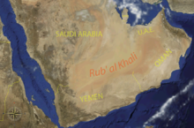 View of the Rub' al Khali Basin | |
 | |
 Tectonic elements of the Rub' al Khali Basin | |
 Stratigraphic column of the eastern Arabian Peninsula | |
| Coordinates | 21°00′00″N 51°30′00″E / 21.00000°N 51.50000°ECoordinates: 21°00′00″N 51°30′00″E / 21.00000°N 51.50000°E |
| Etymology | Arabic: "empty quarter" |
| Region | Rub' al Khali |
| Country | |
| State(s) | Eastern Province, Najran & Riyadh Regions |
| Cities | Najran |
| Characteristics | |
| On/Offshore | Onshore |
| Boundaries | (N), (E), (S), Arabian Shield (W) |
| Part of | Arabian Desert |
| Area | 560,000 km2 (220,000 sq mi) |
| Hydrology | |
| River(s) | Wadis |
| Lake(s) | Occasional saline lakes |
| Geology | |
| Basin type | Active margin (early Early Cretaceous-recent) Passive margin (Early-Mid Mesozoic) Back-arc (Late Paleozoic-Early Mesozoic) (Proterozoic-Early Paleozoic) |
| Plate | Arabian |
| Orogeny | Hercynian (Paleozoic) Break-up of Pangea (Mesozoic) Zagros-Alpine (Cenozoic) |
| Age | Neoproterozoic to Holocene |
| Stratigraphy | Stratigraphy |
| Faults | , |
| Field(s) | Oil: Shaybah, Gas: |

The Rub' al Khali Basin (ٱلرُّبْع ٱلْخَالِي) or ar-Rubʻ al-Khālī / ar-rubʿ al-ḵālī Basin, Arabic for "Empty Quarter Basin", is a major endorheic sedimentary basin of approximately 560,000 square kilometres (220,000 sq mi) in southern Saudi Arabia, northeastern Yemen, southeastern Oman and southeasternmost United Arab Emirates. The onshore foreland on Mesozoic rift basin is geographically defined by the eponymous Rub' al Khali and covers the regions of Najran and Riyadh and the Eastern Province. The basin is geologically bound by the in the north, the in the east, the in the south and the Arabian Shield in the west. Politically, the southwestern boundary is formed by the border with Yemen and the border with Oman forms the southeastern boundary.
The stratigraphy of the basin ranges from Proterozoic to recent and comprises various cycles of clastic and carbonate sediments separated by regional unconformities. The stratigraphic column contains various levels of source rock formations, and reservoirs and seals are common in the late Paleozoic and Mesozoic succession. Traps are formed by the compression of the Oman Thrust in the east.
Compared to the petroleum producing areas to the north of the basin, the Rub' al Khali Basin is relatively underexplored and has two producing oil fields (Shaybah and ) and a gas field; . The Total Petroleum System assessment made by the USGS in 2019 analyzed the potential of the basin, with the Silurian and Cretaceous / systems as most prolific.
Stratigraphy[]
The stratigraphy of the Rub' al Khali Basin ranges from the Neoproterozoic, locally referred to as "Infracambrian", to recent deposits. The unconsolidated Quaternary cover is formed by sand dunes in various forms. Saline and freshwater lakes and ponds are rare in the region but sometimes they occur between sand dunes and barchanoid ridges.[1]
| Age | Group | Formation | Lithologies | Depositional environment | Maximum thickness | Petroleum geology | Notes |
|---|---|---|---|---|---|---|---|
| Quaternary | Alluvium | Sands, silts and conglomerates | Non pattern dunes, sand sheets, gravel sheets, sabkhas, saline and freshwater lakes and ponds, linear sand dunes, seif dunes, and megabarchan dunes, barchanoid ridges, star dunes | 900 m (3,000 ft) | Overburden | ||
| Pliocene | Overburden | ||||||
| Miocene | Overburden | ||||||
| Overburden | |||||||
| Overburden | |||||||
| Oligocene | Oligocene unconformity | ||||||
| Eocene | Overburden | ||||||
| Overburden | |||||||
| Paleocene | Overburden | ||||||
| Late Cretaceous | Reservoir, seal | ||||||
| Late Cretaceous | - | Reservoir | |||||
| Source, seal | |||||||
| Reservoir | |||||||
| Seal | |||||||
| Reservoir, seal | |||||||
| Early Cretaceous | Source, reservoir | ||||||
| Reservoir | |||||||
| Source | |||||||
| Late Jurassic | Seal | ||||||
| Reservoir | |||||||
| Middle Jurassic | Reservoir | ||||||
| Reservoir | |||||||
| Source | |||||||
| Early Jurassic | Reservoir, seal, source | ||||||
| Source | |||||||
| Laterites | Deltaic to coastal | Reservoir | |||||
| Triassic | Conglomerates, sandstones and intercalated shales | Alluvial fans to shallow marine | Reservoir, seal | ||||
| - | Fine-grained clastics and dolomitic mudstones | Continental to near-shore | Reservoir | ||||
| Silty and gypsiferous shales | Shallow marine | Source | |||||
| Permian | Dolomites, limestones, sandstones, shales, evaporites | Shallow marine to intertidal | 900 m (3,000 ft) | Reservoir, seal, source | |||
| Late Carboniferous | Reservoir, source, seal | ||||||
| Early-Mid Carboniferous | Pre-Unayzah unconformity | ||||||
| Devonian | |||||||
| Devonian | Source | ||||||
| Devonian | Seal | ||||||
| Silurian | - | Reservoir | |||||
| Silurian | Black shale | Source, seal | |||||
| Ordovician | |||||||
| Pre-Saq unconformity | |||||||
| Early-Mid Cambrian | Huqf | Halite | Seal | ||||
| Neoproterozoic | Metasediments | ||||||
Basin evolution[]
The overall history of the Rub' al Khali Basin goes back to the Proterozoic ("Precambrian"). The first regional tectonic signature in the history is recorded as the end-Ediacaran unconformity, followed by the pre-Siq unconformity affecting the western and southwestern edges of the basin.[21] Throughout the earlier periods of the Paleozoic, the went through an extensional tectonic phase, which ended with a regional Carboniferous unconformity, representing the Hercynian orogenic compressional stage.[22] From the Early Permian onwards, the basin experienced back-arc extension on the edge of Gondwana, leading to the formation of the regional with anhydrite and halite deposition. This tectonic regime gradually transitioned into a passive margin setting with the opening of the Neo-Tethys in the Early Triassic.[4]
During the early Mesozoic, this tectonic quiescent stage remained active, laying down the majority of the sedimentary sequence, including the main reservoirs of the succession. Following the tectonic subsidence at the border of the shallow Tethys ocean, the basin experienced its first compressional stage in the earliest Early Cretaceous, represented to the south of the basin by the .[23] To the east of the Rub' al-Khali Basin, this resulted in the obduction of the Semail Ophiolite, an oceanic crustal sequence which today is widely studied in the . Two stages of tectonic uplift are noted towards the end of the Cenomanian (around 94 Ma, close to the Cenomanian-Turonian turnover) and in the middle Santonian, approximately 80 Ma.[24] This phase of ophiolite obduction lasted until Middle to Late Eocene times. The active compression caused by the Alpine orogeny and represented in the Middle Eastern territories by the Zagros fold and thrust belt, continued in the late Paleogene and Neogene, with the main phase of uplift lasting from about 25 to 18 Ma.[25] The Quaternary overburden section of the active margin stage of the basin contains sands, silts, clays and conglomerates deposited in sand dunes (ergs) and sabkhas. The sequence is disturbed by the impact of various meteorites in a series of craters known as the Wabar craters.
Petroleum geology[]

Petroleum exploration in Saudi Arabia commenced in 1937 with the acquisition of seismic surveys, continuing until the end of the 20th century. This has resulted in almost complete coverage of the main producing areas. One of the most successful methods used is the long-range refraction profile using the Hith anhydrite as the refractor.[26]
The Rub' al Khali Basin comprises various petroleum systems, defined as Total Petroleum Systems (TPS) by the United States Geological Survey (USGS), from most to least extensive in the basin:[27]
- Silurian (201903)
- Cretaceous / (201901)
- Jurassic /- (201902)
- Arabian Sub-Basin /Hanifa-Arab (202102)
- Central Arabia Qusaiba-Paleozoic (202101)
- North Oman Huqf- (201601)
- North Oman Huqf/'Q'- (201401)
- Middle Cretaceous (201602)
The North Oman Huqf/'Q'- TPS extends diagonally across the central portion of the Makaram-Mabrouk high portion of the Central Oman Platform, into the .[28]
The main total petroleum system of the basin centers around the Ordovician to Silurian Qusaiba Formation as source rock, charging the Permian Khuff Formation, with minor reservoirs the Silurian Tawil, Devonian Jubah and Carboniferous Unayzah Formations, all sealed by overlying shaly and evaporite levels, with as main regional seal the evaporites of the Khuff. Structural traps are formed by the compression from the east during the Late Cretaceous and Paleogene to Neogene. The for oil has been estimated to the Jurassic-Cretaceous boundary and for gas during the Late Cretaceous.[29]
Petroleum exploration and production[]
Oil exploration work started in the Rub' al Khali Basin in the 1950s. Until 1990, only two oil fields were discovered by Saudi Aramco, the Shaybah and , adjacent to the border with Abu Dhabi. The estimated original recoverable oil reserves of the Shaybah Field, which was discovered in 1968 are 1.828 billion barrels. The reservoir for both fields is in the Lower Cretaceous Shu'aiba Formation. In addition to the discovery of those two oil fields, the was discovered in the same area in 1967. Gas accumulations were found in the Arab C, D, and Jubaila Formations of the Jurassic. The estimated recoverable gas reserves of this field are 3.3 billion cubic metres.[30]
A 2019 USGS study on the basin concluded that the Rub' al Khali Basin could contain 242 undiscovered oil fields, ranging from 4 to 8192 million barrels of oil (MMBO),[31] and a mean number of 267 gas fields with estimated volumes between 24 and 98,304 billion cubic feet (BCF).[32]
See also[]
- General geology
References[]
- ^ Kumar & Abdullah, 2011, p.115
- ^ Kumar & Abdullah, 2011, p.107
- ^ Kumar & Abdullah, 2011, p.112
- ^ a b c d e f g h i j k l m n o p q r s t u v w x Ziegler, 2001, p.446
- ^ a b c d e f g h i j k l m n o p q r s t u v w x y z aa ab ac ad ae af ag ah ai aj ak al Jaju et al., 2016, p.3
- ^ Ziegler, 2001, p.457
- ^ a b c d e f g Al Johl & Al Laboun, 2015, p.6
- ^ Ziegler, 2001, p.455
- ^ a b Ziegler, 2001, p.453
- ^ a b c Vaslet et al., 2005, p.80
- ^ a b c d e f g h i j k Konert et al., 2001, p.414
- ^ a b c d e f g h i Machado, 2020, p.3
- ^ a b Bassis, 2017, p.10
- ^ Crasquin-Soleau et al., 2006, p.57
- ^ Ziegler, 2001, p.449
- ^ a b Bassis, 2017, p.13
- ^ a b Bassis, 2017, p.12
- ^ Bassis, 2017, p.9
- ^ Bassis, 2017, p.8
- ^ Bassis, 2017, p.7
- ^ Jaju et al., 2016, p.4
- ^ Stewart, 2016, p.2420
- ^ Ziegler, 2001, p.470
- ^ Ali et al., 2018, p.178
- ^ Ali et al., 2018, p.179
- ^ Alhuwaidi, 1990, p.21
- ^ USGS, 2019, p.1
- ^ Pollastro, 1999, p.9
- ^ Lučić & Bosworth, 2019, p.237
- ^ Alhuwaidi, 1990, p.23
- ^ USGS, 2019, p.9
- ^ USGS, 2019, p.10
Bibliography[]
General geology[]
- . 2020. Biostratigraphy of Siliciclastic Reservoirs of the Arabian Plate: Current State and Future Challenges, 1–3. 2019 AAPG Middle East Region Geoscience Technology Workshop. Accessed 2020-05-17.
- ; ; , and . 2018. Subsidence History and Seismic Stratigraphy of the Western Musandam Peninsula, Oman–United Arab Emirates Mountains. Tectonics 36. 154–181. Accessed 2020-05-17.
- . 2017. Petrography, geochemistry and provenance of Saudi Arabian Palaeozoic sandstones, 1–159. Technische Universität Darmstadt. Accessed 2020-05-17.
- . 2016. Structural geology of the Rub' Al-Khali Basin, Saudi Arabia. Tectonics 35. 2417–2438. Accessed 2020-05-17.
- , and . 2015. Neoproterozoic (infracambrian) - Paleozoic Total Petroleum Systems of Arabian Peninsula; an Overview. 2. 1–21. Accessed 2020-05-17.
- , and . 2011. An overview of Origin, Morphology and Distribution of Desert Forms, Sabkhas and Playas of the Rub' al Khali Desert of the Southern Arabian Peninsula. 4. 105–135. Accessed 2020-05-17. ISSN 0974-8350
- ; ; ; ; ; ; ; , and . 2005. The Permian-Triassic Khuff Formation of central Saudi Arabia. GeoArabia 10. 77–134. Accessed 2020-05-17.
- ; ; , and . 2001. Paleozoic Stratigraphy and Hydrocarbon Habitat of the Arabian Plate. GeoArabia 6. 407–442. Accessed 2020-05-17.
- . 2001. Late Permian to Holocene Paleofacies Evolution of the Arabian Plate and its Hydrocarbon Occurrences. GeoArabia 6. 445–504. Accessed 2020-05-17.
- . 1990. Cretaceous Source Rocks - Al Rub' Al-Khali Basin, Saudi Arabia - a geological and geochemical study, 1–278. Imperial College London. Accessed 2020-05-17.
- ; ; , and . 1966. Geology of the Arabian Peninsula - Sedimentary Geology of Saudi Arabia. U.S. Geological Survey Professional Paper 560. 1–147. Accessed 2020-05-17.
Petroleum geology[]
- , and . 2019. Regional Geology and Petroleum Systems of the Main Reservoirs and Source Rocks of North Africa and the Middle East in The Geology of the Arab World — An Overview, 197–289. Springer Geology. Accessed 2020-05-17. ISBN 978-3-319-96794-3
- . 2019. Rub Al Khali Basin - Geologic Province, 1–10. USGS.
- ; ; , and . 2016. Optimal aquifers and reservoirs for CCS and EOR in the Kingdom of Saudi Arabia: an overview. 9. 1–15. Accessed 2020-05-17.
- . 2006. Block 11 (Al Khadrah), 1–5. PEPA.
- . 1999. Ghaba Salt Basin Province and Fahud Salt Basin Province, Oman - Geological Overview and Total Petroleum Systems. USGS Bulletin 2167. 1–44. Accessed 2020-05-17.
Paleontology[]
- ; , and . 2006. Ostracods of the Permian-Triassic Khuff Formation, Saudi Arabia: palaeoecology and palaeobiogeography. GeoArabia 11. 55–76. Accessed 2020-05-17.
- , and . 1983. Late Permian plants including Charophytes from the Khuff Formation of Saudi Arabia. Bulletin of the Natural History Museum Geology 37. 105–112. Accessed 2020-05-17.
External links[]
- Sedimentary basins of Asia
- Passive margins
- Back-arc basins
- Intracratonic basins
- Geology of the Middle East
- Geology of Saudi Arabia
- Geology of Oman
- Geology of the United Arab Emirates
- Geology of Yemen
- Arabian Peninsula
- Najd
- Oil fields of Saudi Arabia
- Oman–Saudi Arabia border
- Oman–Yemen border
- Saudi Arabia–United Arab Emirates border
- Saudi Arabia–Yemen border
- Saudi Aramco