Ruch, Oregon
Ruch, Oregon | |
|---|---|
 | |
 Ruch | |
| Coordinates: 42°14′14″N 123°2′29″W / 42.23722°N 123.04139°WCoordinates: 42°14′14″N 123°2′29″W / 42.23722°N 123.04139°W | |
| Country | United States |
| State | Oregon |
| County | Jackson |
| Area | |
| • Total | 6.73 sq mi (17.44 km2) |
| • Land | 6.73 sq mi (17.44 km2) |
| • Water | 0.0 sq mi (0.0 km2) |
| Elevation | 1,527 ft (465 m) |
| Population (2010) | |
| • Total | 840 |
| • Density | 125/sq mi (48.2/km2) |
| Time zone | UTC-8 (Pacific (PST)) |
| • Summer (DST) | UTC-7 (PDT) |
| ZIP code | 97530 |
| Area code(s) | 458 and 541 |
| FIPS code | 41-64150 |
| GNIS feature ID | 1148830 |


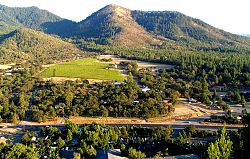
Ruch is an unincorporated community and census-designated place (CDP) in Jackson County, Oregon, United States. It is located on Oregon Route 238, southeast of Grants Pass. As of the 2010 census it had a population of 840.[1]
Ruch was named for Casper M. Ruch, who bought a tract of land where the community now stands in 1896. He built a blacksmith shop, a store and a house. When he was appointed postmaster of the new post office in 1897 and allowed to name it, he named it after himself. The post office closed in 1939.[2]
There are two structures listed on the National Register of Historic Places in Ruch—McKee Bridge and .
The Ruch area is home to several Oregon wineries and is in the Applegate Valley AVA, a sub-appellation of the Rogue Valley AVA (American Viticultural Area). A small elementary school, Ruch Elementary, is located near the center of the community. The school serves Kindergarten - 8th grade with the Cougars as their mascot.
The Applegate River runs through the southwest edge of the valley.
Climate[]
Ruch has a warm-summer Mediterranean climate (Csb) according to the Köppen climate classification system.
| Climate data for Ruch | |||||||||||||
|---|---|---|---|---|---|---|---|---|---|---|---|---|---|
| Month | Jan | Feb | Mar | Apr | May | Jun | Jul | Aug | Sep | Oct | Nov | Dec | Year |
| Record high °F (°C) | 69 (21) |
81 (27) |
84 (29) |
91 (33) |
102 (39) |
109 (43) |
109 (43) |
111 (44) |
106 (41) |
102 (39) |
77 (25) |
71 (22) |
111 (44) |
| Average high °F (°C) | 49.3 (9.6) |
55.6 (13.1) |
60.1 (15.6) |
65.1 (18.4) |
74.3 (23.5) |
81.7 (27.6) |
90.3 (32.4) |
89.6 (32.0) |
83.7 (28.7) |
70.8 (21.6) |
54.9 (12.7) |
47.6 (8.7) |
68.6 (20.3) |
| Average low °F (°C) | 29.9 (−1.2) |
30.6 (−0.8) |
33 (1) |
35.4 (1.9) |
41.1 (5.1) |
46.6 (8.1) |
50.5 (10.3) |
49.6 (9.8) |
44 (7) |
37.8 (3.2) |
33.6 (0.9) |
29.9 (−1.2) |
38.5 (3.6) |
| Record low °F (°C) | 8 (−13) |
2 (−17) |
18 (−8) |
20 (−7) |
25 (−4) |
30 (−1) |
34 (1) |
32 (0) |
22 (−6) |
17 (−8) |
12 (−11) |
−3 (−19) |
−3 (−19) |
| Average precipitation inches (mm) | 4.17 (106) |
2.55 (65) |
2.82 (72) |
1.77 (45) |
1.17 (30) |
0.73 (19) |
0.38 (9.7) |
0.45 (11) |
0.79 (20) |
1.6 (41) |
3.76 (96) |
4.68 (119) |
24.87 (632) |
| Average snowfall inches (cm) | 2.8 (7.1) |
2.8 (7.1) |
1.6 (4.1) |
0.1 (0.25) |
0 (0) |
0 (0) |
0 (0) |
0 (0) |
0 (0) |
0 (0) |
0.6 (1.5) |
3.8 (9.7) |
11.7 (30) |
| Average precipitation days | 14 | 11 | 13 | 11 | 7 | 5 | 2 | 2 | 4 | 7 | 14 | 14 | 104 |
| Source: [3] | |||||||||||||
References[]
- ^ "Geographic Identifiers: 2010 Census Summary File 1 (G001): Ruch CDP, Oregon". American Factfinder. U.S. Census Bureau. Archived from the original on February 13, 2020. Retrieved October 30, 2018.
- ^ McArthur, Lewis A.; McArthur, Lewis L. (2003) [1928]. Oregon Geographic Names (7th ed.). Portland, Oregon: Oregon Historical Society Press. p. 830. ISBN 978-0875952772.
- ^ "RUCH, OR (357391)". Western Regional Climate Center. Retrieved November 26, 2015.
External links[]
Municipalities and communities of Jackson County, Oregon, United States | ||
|---|---|---|
| Cities |  | |
| CDPs | ||
| Other unincorporated communities | ||
| Ghost towns | ||
| ||
This Jackson County, Oregon state location article is a stub. You can help Wikipedia by . |
- Unincorporated communities in Jackson County, Oregon
- Populated places established in 1896
- Census-designated places in Oregon
- Census-designated places in Jackson County, Oregon
- 1896 establishments in Oregon
- Unincorporated communities in Oregon
- Jackson County, Oregon geography stubs