Rupakot Majhuwagadhi Municipality
Diktel Rupakot Majhuwagadhi
दिक्तेल रूपाकोट मझुवागढी | |
|---|---|
Municipality | |
 Diktel Rupakot Majhuwagadhi | |
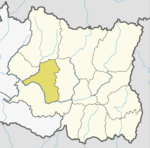
 Diktel Rupakot Majhuwagadhi Location in Province No. 1 | |
| Coordinates: 27°12′50″N 86°47′52″E / 27.21389°N 86.79778°ECoordinates: 27°12′50″N 86°47′52″E / 27.21389°N 86.79778°E | |
| Country | |
| Province | Province No. 1 |
| District | Khotang District |
| Government | |
| • Mayor | Dip Narayan Rijal (NCP) |
| • Deputy Mayor | Bina Devi Rai (NCP) |
| Area | |
| • Total | 246.51 km2 (95.18 sq mi) |
| Area rank | 8th (Province No. 1) |
| Highest elevation | 2,250 m (7,380 ft) |
| Lowest elevation | 700 m (2,300 ft) |
| Population (2011) | |
| • Total | 46,903 |
| • Density | 190/km2 (490/sq mi) |
| [1] | |
| Time zone | UTC+5:45 (NST) |
| Website | official website |


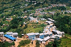
Diktel Rupakot Majhuwagadhi is a Municipality in Khotang District of Province No. 1 of Nepal. The municipality was established in May 2014 merging some existing VDCs: Bamrang, Laphyang and Kahalle as Diktel Municipality.[1][2]
Diktel was renamed to Rupakot Majhuwagadhi on 10 March 2017 after merging some more VDCs. The municipality is divided into 15 wards. It is on 700 m to 2250 m of elevation from sea level. The area of the municipality is 246.51 km2. There are 10,050 households with population of 46,903.[3][4] By 2020, the name commonly used name Diktel was re-added to the municipality's official name.[citation needed]
Transportation[]
Man Maya Airport lies in Old-Diktel offering flights to Kathmandu.[5]
Media[]
To promote local culture, Diktel has two community radio stations: Halesi FM (102.4 MHz) and Rupakot Radio (105.0 MHz).
References[]
- ^ 72 new municipalities announced Archived June 18, 2014, at the Wayback Machine My Republica
- ^ Govt announces 72 new municipalities The Kathmandu Post
- ^ "Introduction". rupakotmajhuwagadhimun.gov.np. Mofald.gov.np. 8 October 2017. Retrieved 23 February 2018.
- ^ "Rupakot Majhuwagadhi Municipality in Nepa Population". www.citypopulation.de. Retrieved 23 February 2018.
- ^ "KHANIDANDA (MANAMAYA RAI) AIRPORT" (PDF). CAAN. Retrieved 5 January 2020.
External links[]
| Wikimedia Commons has media related to Rupakot Majhuwagadhi. |
This article about a location in Khotang District, Nepal is a stub. You can help Wikipedia by . |
- Populated places in Khotang District
- Khotang District
- Nepal municipalities established in 2014
- Municipalities in Province No. 1
- Municipalities in Khotang District
- Khotang District geography stubs